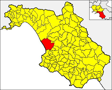
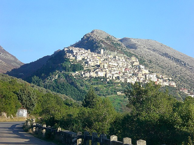
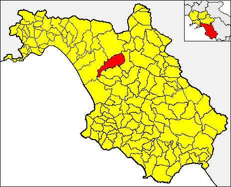
Albanella (Albanella)

- Italian comune
 Hiking in Albanella
Hiking in Albanella, a town located in the province of Salerno in the Campania region of Italy, offers a delightful mix of nature, history, and stunning landscapes. The area is characterized by its hilly terrain and proximity to the spectacular Cilento National Park, making it an excellent destination for hiking enthusiasts.
Hiking Trails:
-
Cilento National Park: Just a short drive from Albanella, this UNESCO World Heritage site has numerous trails that cater to varying skill levels. The park is known for its diverse flora and fauna, ancient ruins, and breathtaking views of the coastline.
-
Mount Stella: A popular hike for more experienced trekkers, it provides panoramic views of the surrounding area, including the Mediterranean Sea. Be sure to check local trail conditions, as some can be challenging.
-
Local Nature Walks: Albanella offers several lesser-known paths that meander through olive groves, vineyards, and scenic countryside, allowing hikers to experience local culture and the serene beauty of rural Italy.
Tips for Hiking in Albanella:
-
Weather: The best times for hiking in the region are usually spring and early fall when the temperatures are moderate. Summer can be quite hot, so plan your hikes for early mornings or late afternoons.
-
Safety: Always ensure you have sufficient water, wear appropriate gear, and consider informing someone about your hiking plans, especially if you’re venturing onto less populated trails.
-
Local Guides: If you're new to the area or unsure about the trails, consider joining a guided hike. Local guides can provide valuable insights and enhance your hiking experience.
-
Preserving Nature: As always, remember to follow Leave No Trace principles to preserve the natural beauty of the area.
Nearby Attractions:
After a day of hiking, you might want to explore the historical sites in Albanella, such as the 11th-century church, or enjoy local cuisine at one of the local trattorias to refuel after an adventurous day.
Overall, hiking in Albanella offers a wonderful opportunity to connect with nature while experiencing the rich culture of southern Italy.
- Country:

- Postal Code: 84044
- Local Dialing Code: 0828
- Licence Plate Code: SA
- Coordinates: 40° 29' 0" N, 15° 7' 0" E


- GPS tracks (wikiloc): [Link]
- AboveSeaLevel: 205 м m
- Area: 40.23 sq km
- Population: 6394
- Web site: http://www.comune.albanella.sa.it
- Wikipedia en: wiki(en)
- Wikipedia: wiki(it)
- Wikidata storage: Wikidata: Q80547
- Wikipedia Commons Category: [Link]
- Freebase ID: [/m/0frdyn]
- GeoNames ID: Alt: [6542064]
- VIAF ID: Alt: [245415940]
- OSM relation ID: [40554]
- Digital Atlas of the Roman Empire ID: [36735]
- ISTAT ID: 065003
- Italian cadastre code: A128
Shares border with regions:


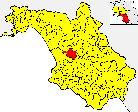
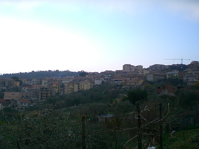
Altavilla Silentina
- Italian comune
Hiking in Altavilla Silentina
Altavilla Silentina, situated in the Campania region of southern Italy, offers a variety of hiking opportunities set against a backdrop of stunning natural beauty. The area features rolling hills, picturesque landscapes, and a rich cultural heritage that enhances the hiking experience. Here are some details about hiking in and around Altavilla Silentina:...
- Country:
- Postal Code: 84045
- Local Dialing Code: 0828
- Licence Plate Code: SA
- Coordinates: 40° 32' 0" N, 15° 8' 0" E
- GPS tracks (wikiloc): [Link]
- AboveSeaLevel: 275 м m
- Area: 52.48 sq km
- Population: 7083
- Web site: [Link]

Capaccio
- Italian comune
Hiking in Capaccio
Capaccio Paestum, located in the Campania region of Italy, is an excellent destination for hiking, offering a rich combination of historical sites, natural beauty, and diverse landscapes. Here are some highlights and tips for hiking in this area:...
- Country:
- Postal Code: 84047
- Local Dialing Code: 0828
- Licence Plate Code: SA
- Coordinates: 40° 25' 0" N, 15° 5' 0" E
- GPS tracks (wikiloc): [Link]
- AboveSeaLevel: 0 м m
- Area: 113 sq km
- Population: 22802
- Web site: [Link]

Castelcivita
- Italian comune
Hiking in Castelcivita
Hiking in Castelcivita, located in the Campania region of Italy, offers a unique blend of stunning landscapes, historical sites, and natural beauty. The area is known for its rugged terrain and the nearby Castelcivita Caves, which are a fascinating attraction for both hikers and nature enthusiasts....
- Country:
- Postal Code: 84020
- Local Dialing Code: 0828
- Licence Plate Code: SA
- Coordinates: 40° 30' 0" N, 15° 14' 0" E
- GPS tracks (wikiloc): [Link]
- AboveSeaLevel: 487 м m
- Area: 57.64 sq km
- Population: 1653
- Web site: [Link]


Eboli
- Italian comune
Hiking in Eboli
Eboli is a town located in the Campania region of Italy, specifically in the province of Salerno. It's situated near the scenic areas of the Cilento National Park, which offers a range of opportunities for hiking enthusiasts. Here are some highlights and tips for hiking in and around Eboli:...
- Country:
- Postal Code: 84020; 84025
- Local Dialing Code: 0828
- Licence Plate Code: SA
- Coordinates: 40° 37' 1" N, 15° 3' 23" E
- GPS tracks (wikiloc): [Link]
- AboveSeaLevel: 145 м m
- Area: 137.58 sq km
- Population: 40058
- Web site: [Link]

Roccadaspide
- Italian comune
Hiking in Roccadaspide
Roccadaspide, located in the province of Salerno in the Campania region of Italy, offers a rich hiking experience with its picturesque landscapes, rolling hills, and diverse flora and fauna. Here are some key aspects to consider when planning a hiking trip in Roccadaspide:...
- Country:
- Postal Code: 84069
- Local Dialing Code: 0828
- Licence Plate Code: SA
- Coordinates: 40° 26' 0" N, 15° 12' 0" E
- GPS tracks (wikiloc): [Link]
- AboveSeaLevel: 340 м m
- Area: 64.16 sq km
- Population: 7116
- Web site: [Link]
Serre, Campania
- Italian comune
Hiking in Serre, Campania
Hiking in Serre, Campania, offers a unique opportunity to explore the natural beauty of the region, characterized by its diverse landscapes, rugged terrain, and rich biodiversity. The Serre, part of the broader Apennine mountain range, is known for its spectacular views, lush forests, and charming villages....
- Country:
- Postal Code: 84028
- Local Dialing Code: 0828
- Licence Plate Code: SA
- Coordinates: 40° 35' 0" N, 15° 11' 0" E
- GPS tracks (wikiloc): [Link]
- AboveSeaLevel: 200 м m
- Area: 67.03 sq km
- Population: 3932
- Web site: [Link]