Allauch (Allauch)

- commune in Bouches-du-Rhône, France
- Country:

- Postal Code: 13190
- Coordinates: 43° 20' 10" N, 5° 28' 56" E


- GPS tracks (wikiloc): [Link]
- Area: 50.3 sq km
- Population: 21332
- Web site: http://www.allauch.com
- Wikipedia en: wiki(en)
- Wikipedia: wiki(fr)
- Wikidata storage: Wikidata: Q269862
- Wikipedia Commons Category: [Link]
- Freebase ID: [/m/028173z]
- GeoNames ID: Alt: [3038159]
- SIREN number: [211300025]
- BnF ID: [152472844]
- VIAF ID: Alt: [149041310]
- GND ID: Alt: [4196640-5]
- Library of Congress authority ID: Alt: [n88644970]
- Quora topic ID: [Allauch]
- Twitter username: Alt: [allauch]
- INSEE municipality code: 13002
Shares border with regions:

Aubagne
- commune in Bouches-du-Rhône, France
- Country:
- Postal Code: 13400
- Coordinates: 43° 17' 27" N, 5° 34' 15" E
- GPS tracks (wikiloc): [Link]
- Area: 54.9 sq km
- Population: 45410
- Web site: [Link]

Marseille
- commune in Bouches-du-Rhône, the second largest city of France
 Hiking in Marseille
Hiking in Marseille offers a wonderful blend of stunning coastal views, dramatic landscapes, and rich natural biodiversity. The Calanques National Park, located just south of the city, is a highlight for hikers. Here are some key aspects to consider when hiking in Marseille:...
- Country:
- Postal Code: 13016; 13015; 13014; 13013; 13012; 13011; 13010; 13009; 13008; 13007; 13006; 13005; 13003; 13004; 13002; 13001; 13000
- Local Dialing Code: 496; 491
- Coordinates: 43° 17' 48" N, 5° 22' 35" E
- GPS tracks (wikiloc): [Link]
- AboveSeaLevel: 12 м m
- Area: 240.62 sq km
- Population: 855393
- Web site: [Link]


Cadolive
- commune in Bouches-du-Rhône, France
Hiking in Cadolive
Cadolive, located in the Provence-Alpes-Côte d'Azur region of France, offers a beautiful setting for hiking enthusiasts. Here are some key points to consider when hiking in Cadolive:...
- Country:
- Postal Code: 13950
- Coordinates: 43° 23' 43" N, 5° 32' 54" E
- GPS tracks (wikiloc): [Link]
- Area: 4.18 sq km
- Population: 2158
- Web site: [Link]


Plan-de-Cuques
- commune in Bouches-du-Rhône, France
Hiking in Plan-de-Cuques
Plan-de-Cuques is a charming commune located in the Bouches-du-Rhône department in the Provence-Alpes-Côte d'Azur region of southern France. Nestled in the foothills of the Calanques, it offers a variety of hiking opportunities, combining beautiful landscapes, diverse flora and fauna, and cultural heritage....
- Country:
- Postal Code: 13380
- Coordinates: 43° 20' 49" N, 5° 27' 47" E
- GPS tracks (wikiloc): [Link]
- Area: 8.52 sq km
- Population: 10464
- Web site: [Link]

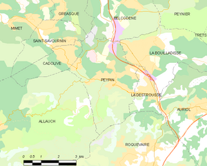
Peypin
- commune in Bouches-du-Rhône, France
Hiking in Peypin
Peypin is a charming commune located in the Bouches-du-Rhône department in the Provence-Alpes-Côte d'Azur region of France. It offers beautiful landscapes and a variety of hiking opportunities, making it a great destination for outdoor enthusiasts....
- Country:
- Postal Code: 13124
- Coordinates: 43° 23' 9" N, 5° 34' 42" E
- GPS tracks (wikiloc): [Link]
- Area: 13.35 sq km
- Population: 5454
- Web site: [Link]


Mimet
- commune in Bouches-du-Rhône, France
Hiking in Mimet
Mimet, a picturesque village located in the Provence-Alpes-Côte d'Azur region of France, is known for its stunning landscapes and diverse hiking opportunities. Nestled at the foot of the Sainte-Baume mountain range, Mimet offers a variety of trails suitable for different skill levels, making it an excellent destination for hikers....
- Country:
- Postal Code: 13105
- Coordinates: 43° 24' 49" N, 5° 30' 20" E
- GPS tracks (wikiloc): [Link]
- Area: 18.7 sq km
- Population: 4607

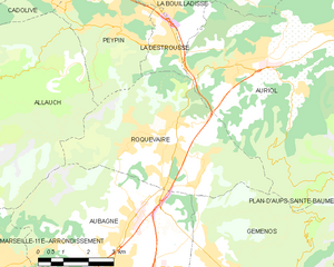
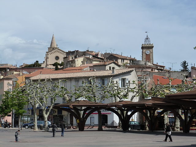
Roquevaire
- commune in Bouches-du-Rhône, France
Hiking in Roquevaire
Roquevaire is a charming commune located in the Provence-Alpes-Côte d'Azur region of France, known for its beautiful landscapes and rich natural environment. Here are some highlights and tips for hiking in Roquevaire:...
- Country:
- Postal Code: 13360
- Coordinates: 43° 20' 58" N, 5° 36' 17" E
- GPS tracks (wikiloc): [Link]
- AboveSeaLevel: 160 м m
- Area: 23.83 sq km
- Population: 8939
- Web site: [Link]