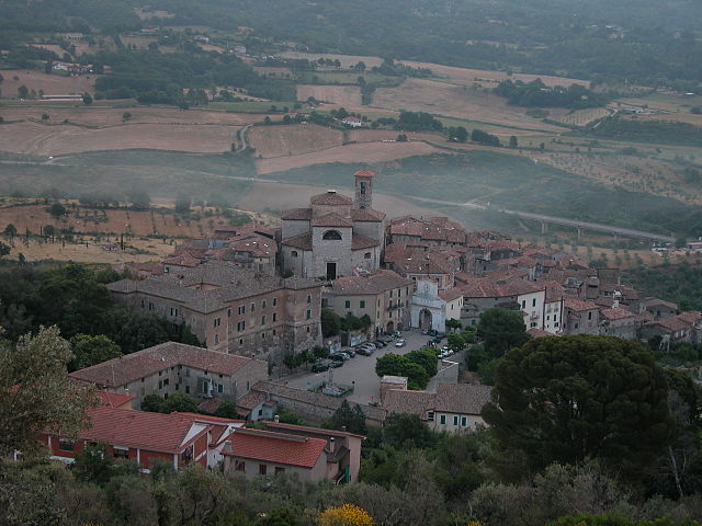
Amaseno (Amaseno)
.svg)
- Italian comune
 Hiking in Amaseno
Amaseno, located in the province of Frosinone in Italy, is a charming area known for its beautiful landscapes, lush greenery, and historical sites. Hiking in Amaseno offers a variety of scenic trails that cater to different skill levels, from easy walks to more challenging hikes.
Key Points for Hiking in Amaseno:
-
Scenic Trails: The region features picturesque paths that wind through forests, hills, and vineyards. The trails often provide stunning views of the surrounding countryside and the Lepini Mountains.
-
Natural Diversity: Amaseno is home to diverse flora and fauna. Hikers might encounter a variety of wildlife and enjoy the rich biodiversity of the area.
-
Cultural Sites: Many trails lead to historical and cultural landmarks, such as ancient churches and ruins. This can add an enriching aspect to your hike, combining nature with history.
-
Weather Conditions: The best time to hike in Amaseno is during the spring and autumn months, when temperatures are mild and the scenery is particularly vibrant. Always check the weather forecast before heading out.
-
Preparation: As with any hiking adventure, it’s essential to wear appropriate footwear, carry enough water, and pack snacks. Consider having a map or GPS device, as some trails may not be clearly marked.
-
Local Guides: If you are unfamiliar with the area, hiring a local guide can enhance your experience. They can offer insight into the local ecology and history.
-
Safety Precautions: Always inform someone about your hiking plans, and consider hiking with a companion, especially on more remote trails. Familiarize yourself with local wildlife and adhere to guidelines for respecting the environment.
Overall, hiking in Amaseno is a rewarding experience that allows you to appreciate the natural beauty of Italy while enjoying physical activity and exploring the rich cultural heritage of the region.
- Country:

- Postal Code: 03021
- Local Dialing Code: 0775
- Licence Plate Code: FR
- Coordinates: 41° 28' 0" N, 13° 20' 0" E


- GPS tracks (wikiloc): [Link]
- AboveSeaLevel: 112 м m
- Area: 77.73 sq km
- Population: 4313
- Web site: http://www.comune.amaseno.net/
- Wikipedia en: wiki(en)
- Wikipedia: wiki(it)
- Wikidata storage: Wikidata: Q116399
- Wikipedia Commons Category: [Link]
- Freebase ID: [/m/0gm913]
- GeoNames ID: Alt: [6538700]
- VIAF ID: Alt: [234328676]
- OSM relation ID: [41281]
- WOEID: [710105]
- ISTAT ID: 060005
- Italian cadastre code: A256
Shares border with regions:
Castro dei Volsci
- Italian comune
Hiking in Castro dei Volsci
Castro dei Volsci is a charming village located in the province of Frosinone, in the Lazio region of Italy. Surrounded by the scenic landscapes of the Aurunci mountains, this area offers a range of hiking opportunities for both beginners and experienced hikers....
- Country:
- Postal Code: 03020
- Local Dialing Code: 0775
- Licence Plate Code: FR
- Coordinates: 41° 31' 0" N, 13° 24' 0" E
- GPS tracks (wikiloc): [Link]
- AboveSeaLevel: 385 м m
- Area: 58.45 sq km
- Population: 4740
- Web site: [Link]


Vallecorsa
- Italian comune
Hiking in Vallecorsa
Vallecorsa is a charming town located in the Lazio region of Italy, surrounded by the scenic landscapes of the Apennine mountains. The area is ideal for hiking enthusiasts looking to explore picturesque trails and enjoy the natural beauty of the Italian countryside....
- Country:
- Postal Code: 03020
- Local Dialing Code: 0775
- Licence Plate Code: FR
- Coordinates: 41° 27' 0" N, 13° 24' 0" E
- GPS tracks (wikiloc): [Link]
- AboveSeaLevel: 350 м m
- Area: 39.28 sq km
- Population: 2574
- Web site: [Link]
Villa Santo Stefano
- Italian comune
Hiking in Villa Santo Stefano
Villa Santo Stefano is a charming town located in the province of Frosinone, Italy, and offers a variety of hiking opportunities for nature enthusiasts and outdoor adventurers. Nestled in the scenic Monti Ernici mountain range, the area is characterized by its beautiful landscapes, lush forests, and rich biodiversity....
- Country:
- Postal Code: 03020
- Local Dialing Code: 0775
- Licence Plate Code: FR
- Coordinates: 41° 31' 0" N, 13° 19' 0" E
- GPS tracks (wikiloc): [Link]
- AboveSeaLevel: 205 м m
- Area: 20.1 sq km
- Population: 1703
- Web site: [Link]


Monte San Biagio
- Italian comune
Hiking in Monte San Biagio
Monte San Biagio, located in the Lazio region of Italy, offers some beautiful hiking opportunities with stunning views and a rich natural environment. Here are a few key points about hiking in the area:...
- Country:
- Postal Code: 04020
- Local Dialing Code: 0771
- Licence Plate Code: LT
- Coordinates: 41° 21' 0" N, 13° 21' 0" E
- GPS tracks (wikiloc): [Link]
- AboveSeaLevel: 133 м m
- Area: 65.1 sq km
- Population: 6308
- Web site: [Link]

Prossedi
- Italian comune
Hiking in Prossedi
Prossedi, a charming village located in the province of Latina in the Lazio region of Italy, offers a variety of hiking opportunities that allow you to explore its beautiful landscapes, rich history, and local culture. Here are some highlights of hiking in Prossedi:...
- Country:
- Postal Code: 04010
- Local Dialing Code: 0773
- Licence Plate Code: LT
- Coordinates: 41° 31' 0" N, 13° 16' 0" E
- GPS tracks (wikiloc): [Link]
- AboveSeaLevel: 206 м m
- Area: 35.37 sq km
- Population: 1203
- Web site: [Link]
Roccasecca dei Volsci
- Italian comune
Hiking in Roccasecca dei Volsci
Roccasecca dei Volsci, a charming town in the province of Frosinone in Italy, offers a variety of hiking opportunities that showcase its beautiful landscapes, historical sites, and natural beauty. Here are some details to consider if you're planning to hike in the area:...
- Country:
- Postal Code: 04010
- Local Dialing Code: 0773
- Licence Plate Code: LT
- Coordinates: 41° 29' 0" N, 13° 13' 0" E
- GPS tracks (wikiloc): [Link]
- AboveSeaLevel: 376 м m
- Area: 23.5 sq km
- Population: 1150
- Web site: [Link]
Sonnino
- Italian comune
Hiking in Sonnino
Sonnino, located in the province of Latina in the Lazio region of Italy, offers a unique hiking experience with its rich history, natural beauty, and panoramic views of the surrounding landscape. Here are some key points about hiking in and around Sonnino:...
- Country:
- Postal Code: 04010
- Local Dialing Code: 0773
- Licence Plate Code: LT
- Coordinates: 41° 25' 0" N, 13° 14' 0" E
- GPS tracks (wikiloc): [Link]
- AboveSeaLevel: 430 м m
- Area: 63.82 sq km
- Population: 7560
- Web site: [Link]