Ambenay (Ambenay)

- commune in Eure, France
- Country:

- Postal Code: 27250
- Coordinates: 48° 50' 10" N, 0° 43' 45" E


- GPS tracks (wikiloc): [Link]
- Area: 16.8 sq km
- Population: 577
- Web site: http://www.ambenay27.fr/
- Wikipedia en: wiki(en)
- Wikipedia: wiki(fr)
- Wikidata storage: Wikidata: Q1009602
- Wikipedia Commons Category: [Link]
- Freebase ID: [/m/02x6cfb]
- Freebase ID: [/m/02x6cfb]
- GeoNames ID: Alt: [6614058]
- GeoNames ID: Alt: [6614058]
- SIREN number: [212700090]
- SIREN number: [212700090]
- BnF ID: [15253251d]
- BnF ID: [15253251d]
- PACTOLS thesaurus ID: [pcrtXh4oYZSgDY]
- PACTOLS thesaurus ID: [pcrtXh4oYZSgDY]
- INSEE municipality code: 27009
- INSEE municipality code: 27009
Shares border with regions:


Rugles
- commune in Eure, France
- Country:
- Postal Code: 27250
- Coordinates: 48° 49' 20" N, 0° 42' 36" E
- GPS tracks (wikiloc): [Link]
- Area: 14.1 sq km
- Population: 2313
- Web site: [Link]
Saint-Antonin-de-Sommaire
- commune in Eure, France
- Country:
- Postal Code: 27250
- Coordinates: 48° 49' 55" N, 0° 40' 5" E
- GPS tracks (wikiloc): [Link]
- Area: 7.16 sq km
- Population: 186
Les Baux-de-Breteuil
- commune in Eure, France
- Country:
- Postal Code: 27160
- Coordinates: 48° 52' 47" N, 0° 48' 43" E
- GPS tracks (wikiloc): [Link]
- Area: 34.22 sq km
- Population: 662

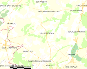
Les Bottereaux
- commune in Eure, France
- Country:
- Postal Code: 27250
- Coordinates: 48° 52' 21" N, 0° 40' 5" E
- GPS tracks (wikiloc): [Link]
- Area: 22.13 sq km
- Population: 358


Neaufles-Auvergny
- commune in Eure, France
- Country:
- Postal Code: 27250
- Coordinates: 48° 51' 55" N, 0° 44' 5" E
- GPS tracks (wikiloc): [Link]
- AboveSeaLevel: 187 м m
- Area: 17.35 sq km
- Population: 424

Bois-Arnault
- commune in Eure, France
- Country:
- Postal Code: 27250
- Coordinates: 48° 48' 44" N, 0° 44' 14" E
- GPS tracks (wikiloc): [Link]
- Area: 12.9 sq km
- Population: 722