Ambierle (Ambierle)

- commune in Loire, France
- Country:

- Postal Code: 42820
- Coordinates: 46° 6' 16" N, 3° 53' 44" E


- GPS tracks (wikiloc): [Link]
- Area: 30.76 sq km
- Population: 1896
- Web site: http://www.ambierle.fr
- Wikipedia en: wiki(en)
- Wikipedia: wiki(fr)
- Wikidata storage: Wikidata: Q1021127
- Wikipedia Commons Category: [Link]
- Freebase ID: [/m/03nw39k]
- Freebase ID: [/m/03nw39k]
- GeoNames ID: Alt: [6452313]
- GeoNames ID: Alt: [6452313]
- SIREN number: [214200032]
- SIREN number: [214200032]
- BnF ID: [15259574b]
- BnF ID: [15259574b]
- VIAF ID: Alt: [136666657]
- VIAF ID: Alt: [136666657]
- GND ID: Alt: [4333741-7]
- GND ID: Alt: [4333741-7]
- PACTOLS thesaurus ID: [pcrtsXzeJoETRW]
- PACTOLS thesaurus ID: [pcrtsXzeJoETRW]
- WOEID: [575897]
- WOEID: [575897]
- INSEE municipality code: 42003
- INSEE municipality code: 42003
Shares border with regions:

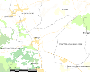
Changy
- commune in Loire, France
- Country:
- Postal Code: 42310
- Coordinates: 46° 8' 31" N, 3° 53' 28" E
- GPS tracks (wikiloc): [Link]
- Area: 13.67 sq km
- Population: 624
- Web site: [Link]


Saint-Haon-le-Vieux
- commune in Loire, France
- Country:
- Postal Code: 42370
- Coordinates: 46° 4' 28" N, 3° 54' 29" E
- GPS tracks (wikiloc): [Link]
- Area: 16.34 sq km
- Population: 964
- Web site: [Link]


Saint-Germain-Lespinasse
- commune in Loire, France
- Country:
- Postal Code: 42640
- Coordinates: 46° 6' 11" N, 3° 57' 45" E
- GPS tracks (wikiloc): [Link]
- AboveSeaLevel: 335 м m
- Area: 15 sq km
- Population: 1223
- Web site: [Link]


Saint-Bonnet-des-Quarts
- commune in Loire, France
- Country:
- Postal Code: 42310
- Coordinates: 46° 7' 54" N, 3° 50' 35" E
- GPS tracks (wikiloc): [Link]
- Area: 32.45 sq km
- Population: 340
Saint-Rirand
- commune in Loire, France
- Country:
- Postal Code: 42370
- Coordinates: 46° 4' 34" N, 3° 50' 55" E
- GPS tracks (wikiloc): [Link]
- Area: 16.43 sq km
- Population: 145

Saint-Forgeux-Lespinasse
- commune in Loire, France
- Country:
- Postal Code: 42640
- Coordinates: 46° 7' 24" N, 3° 55' 52" E
- GPS tracks (wikiloc): [Link]
- Area: 16.19 sq km
- Population: 632