Amigny (Amigny)

- commune in Manche, France
- Country:

- Postal Code: 50620
- Coordinates: 49° 9' 20" N, 1° 10' 46" E


- GPS tracks (wikiloc): [Link]
- Area: 3.69 sq km
- Population: 144
- Wikipedia en: wiki(en)
- Wikipedia: wiki(fr)
- Wikidata storage: Wikidata: Q1077926
- Wikipedia Commons Category: [Link]
- Freebase ID: [/m/04f2r7]
- Freebase ID: [/m/04f2r7]
- GeoNames ID: Alt: [6452366]
- GeoNames ID: Alt: [6452366]
- SIREN number: [215000068]
- SIREN number: [215000068]
- BnF ID: [15261985c]
- BnF ID: [15261985c]
- INSEE municipality code: 50006
- INSEE municipality code: 50006
Shares border with regions:

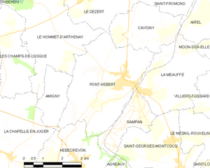
Pont-Hébert
- former commune in Manche, France
- Country:
- Postal Code: 50880
- Coordinates: 49° 10' 1" N, 1° 8' 0" E
- GPS tracks (wikiloc): [Link]
- Area: 14.99 sq km
- Population: 1722


Le Hommet-d'Arthenay
- former commune in Manche, France
- Country:
- Postal Code: 50620
- Coordinates: 49° 11' 24" N, 1° 11' 16" E
- GPS tracks (wikiloc): [Link]
- Area: 14.85 sq km
- Population: 395
- Web site: [Link]

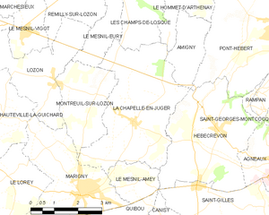
La Chapelle-en-Juger
- former commune in Manche, France
- Country:
- Postal Code: 50570
- Coordinates: 49° 7' 40" N, 1° 12' 53" E
- GPS tracks (wikiloc): [Link]
- Area: 15 sq km
- Population: 656