Andilly (Andilly)

- commune in Haute-Savoie, France
 Hiking in Andilly
Andilly, located in the Haute-Savoie region of southeastern France, is surrounded by stunning landscapes and offers various hiking opportunities that cater to different skill levels and preferences. The region is part of the French Alps, known for its breathtaking mountain scenery, lakes, and charming alpine villages.
Hiking Trails in Andilly
-
Local Trails:
- Andilly itself has a network of smaller hiking trails that allow for scenic walks through the countryside, offering tranquil views and an opportunity to explore local flora and fauna. These paths can provide a gentle introduction to hiking for beginners.
-
Nearby Monts de Genève:
- Just a short journey from Andilly, the Monts de Genève offers more extensive hiking options, including well-marked trails that lead to panoramic viewpoints. The hikes here can vary from easy walking trails to more challenging treks.
-
Lac de Vallon:
- A popular destination for hikers, this lake provides beautiful and serene landscapes. The trails around the lake are generally moderate and suitable for families.
Tips for Hiking in Andilly
-
Best Time to Go: The best time for hiking in the Haute-Savoie region is during late spring (May to June) and early autumn (September to October) when the weather is mild, and the scenery is particularly beautiful.
-
Gear: Ensure you wear proper hiking shoes for better grip and support. Depending on the season, layers of clothing might be needed, as mountain weather can change rapidly.
-
Navigation: While many trails are well-marked, it's advisable to carry a map or use a hiking app for navigation purposes. Downloading offline maps can be beneficial, especially in remote areas.
-
Local Guidance: If you're unfamiliar with the area, consider joining a local hiking group or hiring a guide. They can provide insights into the region's ecology and history.
Environmental Awareness
Hiking in natural areas requires a commitment to sustainability. Follow the Leave No Trace principles by staying on trails, taking your trash with you, and being respectful of wildlife and plants.
Overall, hiking in Andilly and the surrounding Haute-Savoie region is a fantastic way to enjoy the natural beauty of the French Alps while engaging in physical activity. Whether you're looking for a leisurely stroll or an adventurous trek, there's something for everyone!
- Country:

- Postal Code: 74350
- Coordinates: 46° 3' 22" N, 6° 3' 50" E


- GPS tracks (wikiloc): [Link]
- Area: 6.07 sq km
- Population: 855
- Web site: http://www.andilly74.fr
- Wikipedia en: wiki(en)
- Wikipedia: wiki(fr)
- Wikidata storage: Wikidata: Q492064
- Wikipedia Commons Category: [Link]
- Freebase ID: [/m/03qcrng]
- GeoNames ID: Alt: [6613383]
- SIREN number: [217400092]
- BnF ID: [152742694]
- INSEE municipality code: 74009
Shares border with regions:


Cernex
- commune in Haute-Savoie, France
Hiking in Cernex
Cernex is a picturesque village located in the Haute-Savoie region of France, close to the French Alps. While it may not be as widely recognized as some famous hiking destinations, it offers access to stunning natural landscapes and outdoor activities. Here are some insights into hiking in and around Cernex:...
- Country:
- Postal Code: 74350
- Coordinates: 46° 3' 51" N, 6° 3' 3" E
- GPS tracks (wikiloc): [Link]
- Area: 12.66 sq km
- Population: 974
- Web site: [Link]

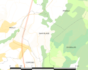
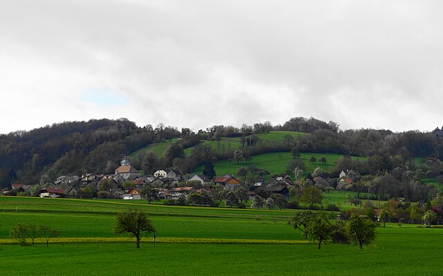
Saint-Blaise, Haute-Savoie
- commune in Haute-Savoie, France
Hiking in Saint-Blaise, Haute-Savoie
Saint-Blaise, located in the Haute-Savoie region of the French Alps, is a beautiful destination for hiking enthusiasts. The area is characterized by stunning alpine scenery, picturesque landscapes, and a variety of trails suited for different skill levels. Here are some highlights about hiking in this region:...
- Country:
- Postal Code: 74350
- Coordinates: 46° 3' 55" N, 6° 5' 19" E
- GPS tracks (wikiloc): [Link]
- Area: 2.55 sq km
- Population: 351
- Web site: [Link]


Copponex
- commune in Haute-Savoie, France
Hiking in Copponex
Copponex is a small village located in the Haute-Savoie region of France, near the border with Switzerland. The surrounding area offers beautiful landscapes, lush greenery, and an array of hiking opportunities, making it a great destination for outdoor enthusiasts....
- Country:
- Postal Code: 74350
- Coordinates: 46° 3' 2" N, 6° 4' 25" E
- GPS tracks (wikiloc): [Link]
- Area: 9.21 sq km
- Population: 1071
- Web site: [Link]


Vers, Haute-Savoie
- commune in Haute-Savoie, France
Hiking in Vers, Haute-Savoie
Hiking in Vers, located in the Haute-Savoie region of France, offers a unique experience characterized by stunning alpine scenery, diverse trails, and rich natural beauty. The region is part of the French Alps, making it an excellent destination for both beginners and experienced hikers....
- Country:
- Postal Code: 74160
- Coordinates: 46° 5' 30" N, 6° 1' 18" E
- GPS tracks (wikiloc): [Link]
- Area: 5.91 sq km
- Population: 812

Présilly
- commune in Haute-Savoie, France
Hiking in Présilly
Présilly, located in the Haute-Savoie region of France, offers a variety of hiking opportunities amidst stunning Alpine scenery. This picturesque village is well-positioned near the French-Swiss border, providing access to beautiful trails and natural landscapes....
- Country:
- Postal Code: 74160
- Coordinates: 46° 5' 35" N, 6° 4' 40" E
- GPS tracks (wikiloc): [Link]
- Area: 8.66 sq km
- Population: 774