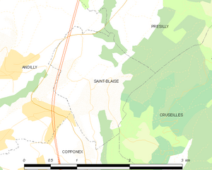
Copponex (Copponex)

- commune in Haute-Savoie, France
 Hiking in Copponex
Copponex is a small village located in the Haute-Savoie region of France, near the border with Switzerland. The surrounding area offers beautiful landscapes, lush greenery, and an array of hiking opportunities, making it a great destination for outdoor enthusiasts.
Hiking Trails in and Around Copponex
-
Local Nature Trails: There are various nature trails that wind through the woodlands and meadows around Copponex. These trails often feature picturesque views of the surrounding mountains and valleys, perfect for casual walks and family hikes.
-
La Vuarmare: A popular hike that starts in Copponex, leading up to La Vuarmare. This trail provides expansive views of the surrounding Alps and is mainly suited for moderate hikers. Be prepared for some elevation gain.
-
Mont Salève: Just a short drive from Copponex, Mont Salève offers a range of hiking trails suited for different skill levels. The views from the summit can be breathtaking, offering panoramas of Geneva and Mont Blanc on clear days.
-
The Plateau des Glieres: Although a bit farther away, this area is well worth the trip. The trails here are marked and accessible and lead through historical sites related to World War II. It’s great for both history buffs and hikers.
Best Time to Hike
The best time to hike in and around Copponex is during the spring (April to June) and the fall (September to October) when the weather is mild, and the landscapes are vibrant. Summer months can be quite warm, while winter might see snow cover in higher elevations.
Tips for Hiking in Copponex
- Gear: Ensure you wear appropriate footwear and carry essentials, such as water, snacks, a first-aid kit, and a map or GPS device.
- Weather Check: The weather in the Alps can be unpredictable, so always check the forecast before heading out.
- Wildlife Awareness: Be mindful of wildlife and follow local guidelines regarding interactions.
- Stay on Marked Paths: To preserve the natural landscape and ensure your safety, stick to marked trails.
Conclusion
Hiking in Copponex provides a beautiful way to connect with nature while enjoying the stunning scenery of the French Alps. Whether you’re a seasoned hiker or a beginner, there are options available for everyone to enjoy the great outdoors!
- Country:

- Postal Code: 74350
- Coordinates: 46° 3' 2" N, 6° 4' 25" E


- GPS tracks (wikiloc): [Link]
- Area: 9.21 sq km
- Population: 1071
- Web site: http://www.copponex.fr
- Wikipedia en: wiki(en)
- Wikipedia: wiki(fr)
- Wikidata storage: Wikidata: Q735184
- Wikipedia Commons Category: [Link]
- Freebase ID: [/m/03ntyp8]
- GeoNames ID: Alt: [3023791]
- SIREN number: [217400886]
- BnF ID: [152743473]
- VIAF ID: Alt: [242304355]
- GND ID: Alt: [4694363-8]
- WOEID: [12659825]
- INSEE municipality code: 74088
Shares border with regions:


Cernex
- commune in Haute-Savoie, France
Hiking in Cernex
Cernex is a picturesque village located in the Haute-Savoie region of France, close to the French Alps. While it may not be as widely recognized as some famous hiking destinations, it offers access to stunning natural landscapes and outdoor activities. Here are some insights into hiking in and around Cernex:...
- Country:
- Postal Code: 74350
- Coordinates: 46° 3' 51" N, 6° 3' 3" E
- GPS tracks (wikiloc): [Link]
- Area: 12.66 sq km
- Population: 974
- Web site: [Link]

Saint-Blaise, Haute-Savoie
- commune in Haute-Savoie, France
Hiking in Saint-Blaise, Haute-Savoie
Saint-Blaise, located in the Haute-Savoie region of the French Alps, is a beautiful destination for hiking enthusiasts. The area is characterized by stunning alpine scenery, picturesque landscapes, and a variety of trails suited for different skill levels. Here are some highlights about hiking in this region:...
- Country:
- Postal Code: 74350
- Coordinates: 46° 3' 55" N, 6° 5' 19" E
- GPS tracks (wikiloc): [Link]
- Area: 2.55 sq km
- Population: 351
- Web site: [Link]


Andilly
- commune in Haute-Savoie, France
Hiking in Andilly
Andilly, located in the Haute-Savoie region of southeastern France, is surrounded by stunning landscapes and offers various hiking opportunities that cater to different skill levels and preferences. The region is part of the French Alps, known for its breathtaking mountain scenery, lakes, and charming alpine villages....
- Country:
- Postal Code: 74350
- Coordinates: 46° 3' 22" N, 6° 3' 50" E
- GPS tracks (wikiloc): [Link]
- Area: 6.07 sq km
- Population: 855
- Web site: [Link]

Cercier
- commune in Haute-Savoie, France
Hiking in Cercier
Cercier, located in the scenic region of France, offers a variety of hiking opportunities that cater to different skill levels and preferences. The area is known for its beautiful landscapes, which include rolling hills, lush forests, and picturesque valleys. Here are some key points to consider when hiking in Cercier:...
- Country:
- Postal Code: 74350
- Coordinates: 46° 1' 31" N, 6° 2' 54" E
- GPS tracks (wikiloc): [Link]
- Area: 11.46 sq km
- Population: 655
- Web site: [Link]


Cruseilles
- commune in Haute-Savoie, France
Hiking in Cruseilles
Cruseilles, located in the Auvergne-Rhône-Alpes region of France, offers scenic hiking opportunities with stunning views of the surrounding countryside and the nearby mountains, including the Saleve and the Bornes mountains. Here are some key points about hiking in Cruseilles:...
- Country:
- Postal Code: 74350
- Coordinates: 46° 2' 3" N, 6° 6' 27" E
- GPS tracks (wikiloc): [Link]
- Area: 25.41 sq km
- Population: 4326
- Web site: [Link]