Apchon (Apchon)

- commune in Cantal, France
- Country:

- Postal Code: 15400
- Coordinates: 45° 14' 57" N, 2° 41' 38" E


- GPS tracks (wikiloc): [Link]
- Area: 12.43 sq km
- Population: 188
- Web site: http://www.apchon.fr
- Wikipedia en: wiki(en)
- Wikipedia: wiki(fr)
- Wikidata storage: Wikidata: Q763120
- Wikipedia Commons Category: [Link]
- Freebase ID: [/m/03mb6lw]
- GeoNames ID: Alt: [6614055]
- SIREN number: [211500095]
- BnF ID: [15248180q]
- VIAF ID: Alt: [238162338]
- GND ID: Alt: [7844703-3]
- INSEE municipality code: 15009
Shares border with regions:


Riom-ès-Montagnes
- commune in Cantal, France
- Country:
- Postal Code: 15400
- Coordinates: 45° 16' 55" N, 2° 39' 35" E
- GPS tracks (wikiloc): [Link]
- Area: 46.48 sq km
- Population: 2591
- Web site: [Link]


Cheylade
- commune in Cantal, France
- Country:
- Postal Code: 15400
- Coordinates: 45° 12' 34" N, 2° 42' 57" E
- GPS tracks (wikiloc): [Link]
- Area: 32.81 sq km
- Population: 229


Collandres
- commune in Cantal, France
- Country:
- Postal Code: 15400
- Coordinates: 45° 14' 10" N, 2° 39' 27" E
- GPS tracks (wikiloc): [Link]
- Area: 43.32 sq km
- Population: 147


Marchastel
- commune in Cantal, France
- Country:
- Postal Code: 15400
- Coordinates: 45° 16' 59" N, 2° 43' 30" E
- GPS tracks (wikiloc): [Link]
- Area: 22.92 sq km
- Population: 151

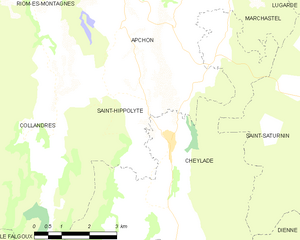
Saint-Hippolyte
- commune in Cantal, France
- Country:
- Postal Code: 15400
- Coordinates: 45° 13' 27" N, 2° 42' 16" E
- GPS tracks (wikiloc): [Link]
- AboveSeaLevel: 1000 м m
- Area: 13.92 sq km
- Population: 116