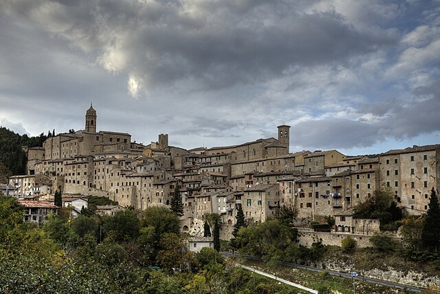
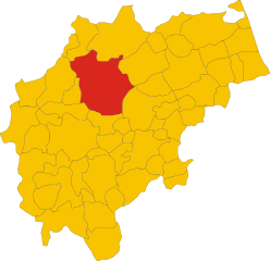
Apiro (Apiro)
.svg)
- Italian comune
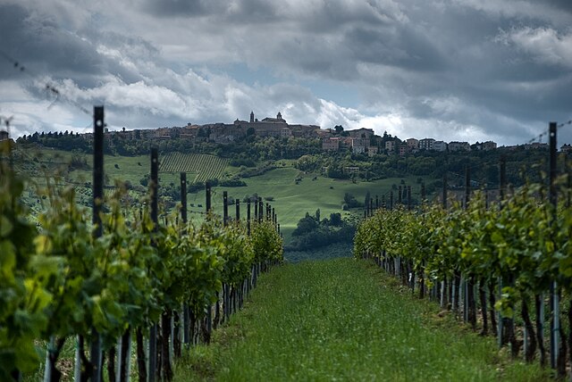
 Hiking in Apiro
Apiro, located in the Marche region of Italy, offers stunning hiking opportunities amidst a picturesque landscape characterized by rolling hills, expansive views, and charming rural settings. Here are some key details about hiking in Apiro:
Scenic Routes
- Natural Parks: The nearby Monte San Vicino and Monte Canfaito Regional Park offers a variety of trails that showcase the rich biodiversity and natural beauty of the area.
- Cultural Trails: Many paths connect to historical sites, such as ancient churches and the remnants of medieval settlements, adding a cultural dimension to your hike.
Trail Difficulty
- Variety of Trails: Trails range from easy walkable paths suitable for families to more challenging hikes for experienced trekkers. Always check trail markers and difficulty levels before embarking.
Flora and Fauna
- Biodiversity: The region is home to various plant and animal species, making it a great spot for nature enthusiasts and photographers.
- Seasonal Changes: Spring wildflowers and autumn foliage can add a stunning backdrop, so consider the seasonal beauty when planning your hike.
Practical Tips
- Preparation: Ensure you wear appropriate footwear, carry enough water, and have snacks. A map or GPS device can be helpful, as some trails may not be well-marked.
- Weather Conditions: Check weather forecasts before your hike, as conditions can change rapidly in the hills.
Local Recommendations
- Local Guides: Consider hiring a local guide for a more enriching experience, especially if you want insights into the natural and cultural history of the region.
- Stay Hydrated: Always bring enough water, especially on warmer days.
Overall, hiking in Apiro provides a wonderful blend of natural beauty, cultural significance, and outdoor adventure. Whether you're looking for a leisurely stroll or a more strenuous hike, you'll find trails that suit your interests. Happy hiking!
- Country:

- Postal Code: 62021
- Local Dialing Code: 0733
- Licence Plate Code: MC
- Coordinates: 43° 23' 35" N, 13° 7' 49" E


- GPS tracks (wikiloc): [Link]
- AboveSeaLevel: 516 м m
- Area: 53.78 sq km
- Population: 2234
- Web site: http://www.apiro.sinp.net/
- Wikipedia en: wiki(en)
- Wikipedia: wiki(it)
- Wikidata storage: Wikidata: Q73249
- Wikipedia Commons Category: [Link]
- Freebase ID: [/m/0gl66f]
- GeoNames ID: Alt: [6536784]
- VIAF ID: Alt: [154240155]
- OSM relation ID: [42415]
- WOEID: [710208]
- UN/LOCODE: [ITAPX]
- ISTAT ID: 043002
- Italian cadastre code: A329
Shares border with regions:

Cupramontana
- Italian comune
Hiking in Cupramontana
Cupramontana is a charming town located in the Marche region of Italy, nestled among rolling hills and vineyards, making it a delightful destination for hiking enthusiasts. Here are some highlights about hiking in and around Cupramontana:...
- Country:
- Postal Code: 60034
- Local Dialing Code: 0731
- Licence Plate Code: AN
- Coordinates: 43° 26' 46" N, 13° 7' 3" E
- GPS tracks (wikiloc): [Link]
- AboveSeaLevel: 505 м m
- Area: 27.4 sq km
- Population: 4616
- Web site: [Link]

Serra San Quirico
- Italian comune
Hiking in Serra San Quirico
Serra San Quirico is a charming village located in the Marche region of Italy, surrounded by beautiful landscapes and offers numerous opportunities for hiking enthusiasts. Here are some key points to consider when hiking in this area:...
- Country:
- Postal Code: 60048
- Local Dialing Code: 0731
- Licence Plate Code: AN
- Coordinates: 43° 26' 52" N, 13° 0' 55" E
- GPS tracks (wikiloc): [Link]
- AboveSeaLevel: 300 м m
- Area: 49.33 sq km
- Population: 2744
- Web site: [Link]


Staffolo
- Italian comune
Hiking in Staffolo
Staffolo is a charming town located in the Marche region of Italy, surrounded by beautiful rolling hills and vineyards, making it a delightful destination for hiking enthusiasts. Here are some highlights and recommendations for hiking in and around Staffolo:...
- Country:
- Postal Code: 60039
- Local Dialing Code: 0731
- Licence Plate Code: AN
- Coordinates: 43° 26' 0" N, 13° 11' 6" E
- GPS tracks (wikiloc): [Link]
- AboveSeaLevel: 442 м m
- Area: 27.5 sq km
- Population: 2247
- Web site: [Link]


Cingoli
- Italian comune
Hiking in Cingoli
Cingoli, often referred to as the "Balcony of the Marche," is located in the Marche region of Italy. The area is known for its breathtaking landscapes, rolling hills, and expansive views of the surrounding countryside, making it a great destination for hiking enthusiasts....
- Country:
- Postal Code: 62011
- Local Dialing Code: 0733
- Licence Plate Code: MC
- Coordinates: 43° 22' 27" N, 13° 12' 59" E
- GPS tracks (wikiloc): [Link]
- AboveSeaLevel: 631 м m
- Area: 148.2 sq km
- Population: 10119
- Web site: [Link]

Matelica
- Italian comune
Hiking in Matelica
Matelica, located in the Marche region of Italy, offers several beautiful hiking opportunities. Nestled in a picturesque valley surrounded by the Apennine Mountains, Matelica provides a stunning backdrop for nature lovers and outdoor enthusiasts....
- Country:
- Postal Code: 62024
- Local Dialing Code: 0737
- Licence Plate Code: MC
- Coordinates: 43° 15' 24" N, 13° 0' 35" E
- GPS tracks (wikiloc): [Link]
- AboveSeaLevel: 354 м m
- Area: 81.1 sq km
- Population: 9665
- Web site: [Link]
Poggio San Vicino
- Italian comune
Hiking in Poggio San Vicino
Poggio San Vicino is a beautiful destination for hiking enthusiasts, located in the Marche region of Italy. It is part of the broader Monte San Vicino e Monte Canfaito Regional Park, which offers stunning landscapes, diverse flora and fauna, and a variety of trails suitable for all experience levels....
- Country:
- Postal Code: 62020
- Local Dialing Code: 0733
- Licence Plate Code: MC
- Coordinates: 43° 22' 29" N, 13° 4' 45" E
- GPS tracks (wikiloc): [Link]
- AboveSeaLevel: 509 м m
- Area: 13.03 sq km
- Population: 244
- Web site: [Link]

San Severino Marche
- Italian comune
Hiking in San Severino Marche
San Severino Marche, located in the Marche region of Italy, offers a beautiful and diverse landscape that's perfect for hiking enthusiasts. The area is characterized by rolling hills, ancient forests, and scenic views, making it an ideal destination for both casual walkers and serious trekkers....
- Country:
- Postal Code: 62027
- Local Dialing Code: 0733
- Licence Plate Code: MC
- Coordinates: 43° 13' 44" N, 13° 10' 38" E
- GPS tracks (wikiloc): [Link]
- AboveSeaLevel: 236 м m
- Area: 194.26 sq km
- Population: 12456
- Web site: [Link]