Arbon District (Bezirk Arbon)

- district of the canton of Thurgau, Switzerland
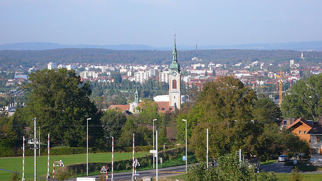
 Hiking in Arbon District
Hiking in the Arbon District, located in the Thurgau Canton of Switzerland, offers a variety of scenic trails that showcase the beautiful landscapes of the region. Here are some key aspects to consider if you're planning to hike in this area:
Scenic Views
Arbon is situated near Lake Constance, providing breathtaking views of the water and the surrounding hills. You can enjoy serene landscapes and beautiful sunsets over the lake, making for a memorable hiking experience.
Trail Options
The district offers various trails suitable for different skill levels, from easy walks along the lakeshore to more challenging hikes in the surrounding hills and woodlands. Popular routes may include:
- Lakeshore Trails: Enjoy leisurely walks along the shoreline of Lake Constance, with the possibility of stopping at quaint villages, parks, and beaches.
- Hilly Terrain: Explore trails that wind through the local hills, where you can experience a bit more elevation and diverse ecosystems.
- Nature Reserves: Some routes may take you through local nature reserves, where you can observe local wildlife and flora.
Accessibility
Hiking trails around Arbon are generally well-marked and accessible. Public transportation options, such as trains and buses, make it easy to reach trailheads or return after your hike.
Seasonal Considerations
- Spring and Summer: Ideal for hiking, with warm weather and blooming flora. Be prepared for potential rain showers.
- Autumn: The changing leaves offer stunning colors, and cooler temperatures make for comfortable hiking.
- Winter: Depending on the snowfall, some trails may be suitable for winter hiking or snowshoeing.
Local Amenities
Arbon has a range of amenities, including cafes, restaurants, and shops, where you can refuel after your hike. Consider packing a picnic to enjoy along the way, especially along the lakeshore.
Preparation Tips
- Gear Up: Wear comfortable hiking boots and carry a water bottle, snacks, a map, or a GPS device.
- Check Weather: Weather can change quickly, so check the forecast before you head out.
- Respect Nature: Stick to marked trails and be mindful of wildlife.
Overall, the Arbon District offers a pleasant hiking experience with a mix of lakeside tranquility and charming landscapes. Enjoy your hiking adventure!
- Country:

- Capital: Arbon
- Licence Plate Code: TG
- Coordinates: 47° 31' 0" N, 9° 26' 0" E


- GPS tracks (wikiloc): [Link]
- AboveSeaLevel: 416 м m
- Area: 88.8 sq km
- Wikipedia en: wiki(en)
- Wikipedia: wiki(de)
- Wikidata storage: Wikidata: Q546803
- Wikipedia Commons Category: [Link]
- Freebase ID: [/m/0g3tlk]
- GeoNames ID: Alt: [8260144]
- VIAF ID: Alt: [243208968]
- archINFORM location ID: [42275]
- HDS ID: [1852]
Includes regions:

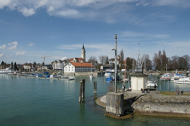
Arbon
- municipality in Switzerland
Hiking in Arbon
Arbon, a picturesque town situated on the shores of Lake Constance in Switzerland, offers a variety of hiking opportunities in its surrounding areas. The region features a mix of beautiful landscapes, including lakes, forests, vineyards, and rolling hills. Here are some highlights for hiking around Arbon:...
- Country:
- Postal Code: 9320
- Local Dialing Code: 071
- Licence Plate Code: TG
- Coordinates: 47° 30' 55" N, 9° 25' 9" E
- GPS tracks (wikiloc): [Link]
- AboveSeaLevel: 402 м m
- Area: 5.9 sq km
- Population: 14537
- Web site: [Link]

Egnach
- municipality in Switzerland
Hiking in Egnach
Egnach is a charming village located in the canton of Thurgau, Switzerland, situated near the shores of Lake Constance. The area is known for its stunning natural beauty and offers various hiking opportunities that cater to all levels of hikers....
- Country:
- Postal Code: 9322
- Local Dialing Code: 071
- Licence Plate Code: TG
- Coordinates: 47° 31' 44" N, 9° 21' 55" E
- GPS tracks (wikiloc): [Link]
- AboveSeaLevel: 442 м m
- Area: 18.5 sq km
- Population: 4708
- Web site: [Link]
Romanshorn
- town and municipality in Thurgau, Switzerland
Hiking in Romanshorn
Romanshorn is a charming town located on the shores of Lake Constance in Switzerland, known for its picturesque landscapes and outdoor activities, including hiking. Here are some highlights and tips for hiking in and around Romanshorn:...
- Country:
- Postal Code: 8590
- Local Dialing Code: 071
- Licence Plate Code: TG
- Coordinates: 47° 34' 0" N, 9° 23' 0" E
- GPS tracks (wikiloc): [Link]
- AboveSeaLevel: 406 м m
- Area: 8.7 sq km
- Population: 10969
- Web site: [Link]
Dozwil
- municipality in Switzerland
Hiking in Dozwil
Dozwil is a picturesque municipality located in the canton of Thurgau, Switzerland. It offers beautiful countryside views and charming landscapes, making it a great destination for hikers. The region is known for its rolling hills, scenic trails, and proximity to Lake Constance, which enhances the natural beauty of the area....
- Country:
- Postal Code: 8582
- Local Dialing Code: 071
- Licence Plate Code: TG
- Coordinates: 47° 34' 0" N, 9° 18' 59" E
- GPS tracks (wikiloc): [Link]
- AboveSeaLevel: 465 м m
- Area: 1.3 sq km
- Population: 706
- Web site: [Link]
Roggwil
- municipality of Switzerland
Hiking in Roggwil
Roggwil, located in the Thurgau region of Switzerland, offers a variety of hiking opportunities that cater to different skill levels and preferences. Here are some highlights and tips for hiking in this picturesque area:...
- Country:
- Postal Code: 9325
- Local Dialing Code: 071
- Licence Plate Code: TG
- Coordinates: 47° 29' 58" N, 9° 23' 42" E
- GPS tracks (wikiloc): [Link]
- AboveSeaLevel: 440 м m
- Area: 11.9 sq km
- Population: 3066
- Web site: [Link]
Uttwil
- municipality in Switzerland
Hiking in Uttwil
Uttwil is a charming village located in the canton of Thurgau in Switzerland, near the shores of Lake Constance (Bodensee). While it may not be as popular as some other hiking destinations in Switzerland, it offers scenic trails and picturesque landscapes suitable for hiking enthusiasts. Here are a few highlights about hiking in and around Uttwil:...
- Country:
- Postal Code: 8592
- Local Dialing Code: 071
- Licence Plate Code: TG
- Coordinates: 47° 34' 37" N, 9° 20' 17" E
- GPS tracks (wikiloc): [Link]
- AboveSeaLevel: 442 м m
- Area: 4.3 sq km
- Population: 1857
- Web site: [Link]
Horn
- municipality in Switzerland
Hiking in Horn
Hiking in Horn, Switzerland, offers a scenic and picturesque experience, especially due to its location along Lake Constance (Bodensee) in the Canton of Thurgau. The area is characterized by beautiful landscapes, rolling hills, vineyards, and stunning views of the lake and the distant Alps....
- Country:
- Postal Code: 9326
- Local Dialing Code: 071
- Licence Plate Code: TG
- Coordinates: 47° 30' 39" N, 9° 27' 43" E
- GPS tracks (wikiloc): [Link]
- AboveSeaLevel: 402 м m
- Area: 1.71 sq km
- Population: 2739
- Web site: [Link]
Hefenhofen
- municipality in Switzerland
Hiking in Hefenhofen
Hefenhofen is a small village in the province of Thurgau, Switzerland, situated near the shores of Lake Constance. Hiking in this area offers a mix of scenic landscapes, lush greenery, and picturesque views of the lake and surrounding hills....
- Country:
- Postal Code: 8580
- Local Dialing Code: 071
- Licence Plate Code: TG
- Coordinates: 47° 32' 59" N, 9° 18' 0" E
- GPS tracks (wikiloc): [Link]
- AboveSeaLevel: 451 м m
- Area: 6.1 sq km
- Population: 1194
- Web site: [Link]

Sommeri
- municipality in Switzerland
Hiking in Sommeri
Sommeri is a picturesque area located in the canton of Thurgau in Switzerland, known for its beautiful landscapes, rolling hills, and serene lakeside views, particularly along Lake Constance. Hiking in Sommeri offers a variety of trails suitable for different skill levels, making it an excellent destination for both beginners and experienced hikers....
- Country:
- Postal Code: 8580
- Local Dialing Code: 071
- Licence Plate Code: TG
- Coordinates: 47° 33' 59" N, 9° 17' 0" E
- GPS tracks (wikiloc): [Link]
- AboveSeaLevel: 465 м m
- Area: 4.2 sq km
- Population: 565
- Web site: [Link]
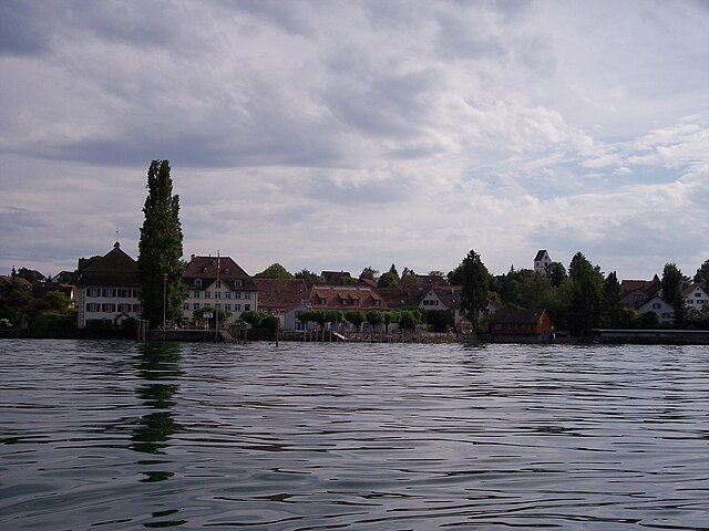
Salmsach
- municipality in Switzerland
Hiking in Salmsach
Salmsach is a beautiful village located on the shores of Lake Constance in Switzerland, offering a tranquil setting for outdoor enthusiasts and hikers alike. The region is characterized by its picturesque landscapes, charming vineyards, and proximity to the lake, making it an ideal spot for hiking....
- Country:
- Postal Code: 8599
- Local Dialing Code: 071
- Licence Plate Code: TG
- Coordinates: 47° 32' 59" N, 9° 21' 16" E
- GPS tracks (wikiloc): [Link]
- AboveSeaLevel: 415 м m
- Area: 2.6 sq km
- Population: 1425
- Web site: [Link]

Kesswil
- municipality in Switzerland
Hiking in Kesswil
Kesswil, located on the shores of Lake Constance (Bodensee) in Switzerland, is an excellent starting point for various hiking adventures. The region offers a mix of scenic lakeside paths, gentle hills, and more challenging trails that lead into the nearby hilly terrain of the Appenzell region and the Swiss Alps. Here are some highlights for hiking in and around Kesswil:...
- Country:
- Postal Code: 8593
- Local Dialing Code: 071
- Licence Plate Code: TG
- Coordinates: 47° 35' 15" N, 9° 18' 46" E
- GPS tracks (wikiloc): [Link]
- AboveSeaLevel: 448 м m
- Area: 4.4 sq km
- Population: 1001
- Web site: [Link]

Amriswil
- municipality in Switzerland
Hiking in Amriswil
Amriswil, located in the canton of Thurgau in Switzerland, offers beautiful landscapes and a variety of hiking opportunities. The region is characterized by rolling hills, picturesque countryside, and proximity to Lake Constance, making it an excellent destination for outdoor enthusiasts. Here are some highlights for hiking in and around Amriswil:...
- Country:
- Postal Code: 8580
- Local Dialing Code: 071
- Licence Plate Code: TG
- Coordinates: 47° 32' 59" N, 9° 18' 0" E
- GPS tracks (wikiloc): [Link]
- AboveSeaLevel: 437 м m
- Area: 19.1 sq km
- Population: 13462
- Web site: [Link]
Shares border with regions:


Weinfelden District
- district of the canton of Thurgau, Switzerland
Hiking in Weinfelden District
Weinfelden District, located in the canton of Thurgau in Switzerland, offers a variety of hiking opportunities that showcase the natural beauty of the region. Here are some highlights for hiking enthusiasts:...
- Country:
- Capital: Weinfelden
- Licence Plate Code: TG
- Coordinates: 47° 34' 0" N, 9° 6' 0" E
- GPS tracks (wikiloc): [Link]
- AboveSeaLevel: 447 м m
- Area: 227.2 sq km

Kreuzlingen District
- district of the canton of Thurgau, Switzerland
Hiking in Kreuzlingen District
Kreuzlingen District, located in the canton of Thurgau in Switzerland, offers a variety of scenic hiking opportunities, especially due to its proximity to the beautiful Lake Constance (Bodensee) and the surrounding natural landscapes. Here are some highlights of hiking in the area:...
- Country:
- Capital: Kreuzlingen
- Licence Plate Code: TG
- Coordinates: 47° 38' 0" N, 9° 10' 0" E
- GPS tracks (wikiloc): [Link]
- AboveSeaLevel: 511 м m
- Area: 129 sq km