Argentré (Argentré)

- commune in Mayenne, France
- Country:

- Postal Code: 53210
- Coordinates: 48° 5' 3" N, 0° 38' 29" E


- GPS tracks (wikiloc): [Link]
- Area: 36.77 sq km
- Population: 2766
- Web site: http://argentre.fr
- Wikipedia en: wiki(en)
- Wikipedia: wiki(fr)
- Wikidata storage: Wikidata: Q646648
- Wikipedia Commons Category: [Link]
- Freebase ID: [/m/03np_g5]
- GeoNames ID: Alt: [6452388]
- SIREN number: [215300070]
- BnF ID: [15263801q]
- Twitter username: Alt: [argentre]
- INSEE municipality code: 53007
Shares border with regions:


Louvigné
- commune in Mayenne, France
- Country:
- Postal Code: 53210
- Coordinates: 48° 3' 25" N, 0° 37' 49" E
- GPS tracks (wikiloc): [Link]
- Area: 12.56 sq km
- Population: 1108

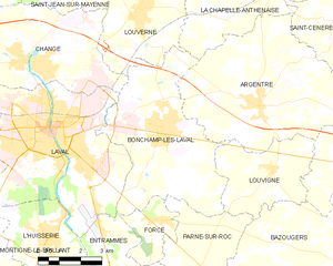
Bonchamp-lès-Laval
- commune in Mayenne, France
- Country:
- Postal Code: 53960
- Coordinates: 48° 4' 27" N, 0° 42' 5" E
- GPS tracks (wikiloc): [Link]
- Area: 27.51 sq km
- Population: 5900
- Web site: [Link]


La Chapelle-Rainsouin
- commune in Mayenne, France
- Country:
- Postal Code: 53150
- Coordinates: 48° 5' 55" N, 0° 31' 12" E
- GPS tracks (wikiloc): [Link]
- Area: 18.05 sq km
- Population: 417


Soulgé-sur-Ouette
- commune in Mayenne, France
- Country:
- Postal Code: 53210
- Coordinates: 48° 3' 37" N, 0° 34' 12" E
- GPS tracks (wikiloc): [Link]
- AboveSeaLevel: 100 м m
- Area: 22.94 sq km
- Population: 1093

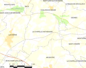
La Chapelle-Anthenaise
- commune in Mayenne, France
- Country:
- Postal Code: 53950
- Coordinates: 48° 7' 21" N, 0° 40' 38" E
- GPS tracks (wikiloc): [Link]
- Area: 19.89 sq km
- Population: 975
- Web site: [Link]


Saint-Céneré
- former commune in Mayenne, France
- Country:
- Postal Code: 53150
- Coordinates: 48° 7' 18" N, 0° 35' 41" E
- GPS tracks (wikiloc): [Link]
- Area: 18.89 sq km
- Population: 526