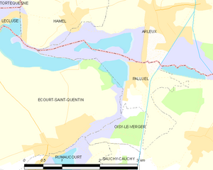
Arleux (Arleux)
- commune in Nord, France
- Country:

- Postal Code: 59151
- Coordinates: 50° 16' 49" N, 3° 6' 23" E


- GPS tracks (wikiloc): [Link]
- Area: 11.1 sq km
- Population: 3031
- Web site: http://www.arleux.fr/
- Wikipedia en: wiki(en)
- Wikipedia: wiki(fr)
- Wikidata storage: Wikidata: Q61573
- Wikipedia Commons Category: [Link]
- Freebase ID: [/m/03h3q1v]
- Freebase ID: [/m/03h3q1v]
- GeoNames ID: Alt: [3036932]
- GeoNames ID: Alt: [3036932]
- SIREN number: [215900150]
- SIREN number: [215900150]
- BnF ID: [152665933]
- BnF ID: [152665933]
- VIAF ID: Alt: [144462937]
- VIAF ID: Alt: [144462937]
- Library of Congress authority ID: Alt: [n2006026045]
- Library of Congress authority ID: Alt: [n2006026045]
- INSEE municipality code: 59015
- INSEE municipality code: 59015
Shares border with regions:


Palluel
- commune in Pas-de-Calais, France
- Country:

- Postal Code: 62860
- Coordinates: 50° 16' 2" N, 3° 5' 55" E


- GPS tracks (wikiloc): [Link]
- Area: 2.77 sq km
- Population: 553


Brunémont
- commune in Nord, France
- Country:

- Postal Code: 59151
- Coordinates: 50° 16' 23" N, 3° 8' 21" E


- GPS tracks (wikiloc): [Link]
- Area: 1.95 sq km
- Population: 707


Oisy-le-Verger
- commune in Pas-de-Calais, France
- Country:

- Postal Code: 62860
- Coordinates: 50° 15' 1" N, 3° 7' 26" E


- GPS tracks (wikiloc): [Link]
- Area: 11.36 sq km
- Population: 1246


Bugnicourt
- commune in Nord, France
- Country:

- Postal Code: 59151
- Coordinates: 50° 17' 27" N, 3° 9' 21" E


- GPS tracks (wikiloc): [Link]
- Area: 6.28 sq km
- Population: 956


Estrées
- commune in Nord, France
- Country:

- Postal Code: 59151
- Coordinates: 50° 18' 1" N, 3° 4' 11" E


- GPS tracks (wikiloc): [Link]
- Area: 5.82 sq km
- Population: 1111


Cantin
- commune in Nord, France
- Country:

- Postal Code: 59169
- Coordinates: 50° 18' 33" N, 3° 7' 33" E


- GPS tracks (wikiloc): [Link]
- Area: 9.32 sq km
- Population: 1521
- Web site: [Link]


Écourt-Saint-Quentin
- commune in Pas-de-Calais, France
- Country:

- Postal Code: 62860
- Coordinates: 50° 15' 2" N, 3° 4' 16" E


- GPS tracks (wikiloc): [Link]
- Area: 9.49 sq km
- Population: 1678
- Web site: [Link]


Hamel
- commune in Nord, France
- Country:

- Postal Code: 59151
- Coordinates: 50° 16' 48" N, 3° 4' 26" E


- GPS tracks (wikiloc): [Link]
- Area: 3.59 sq km
- Population: 771
