arrondissement of Digne-les-Bains (arrondissement de Digne-les-Bains)

- arrondissement of France
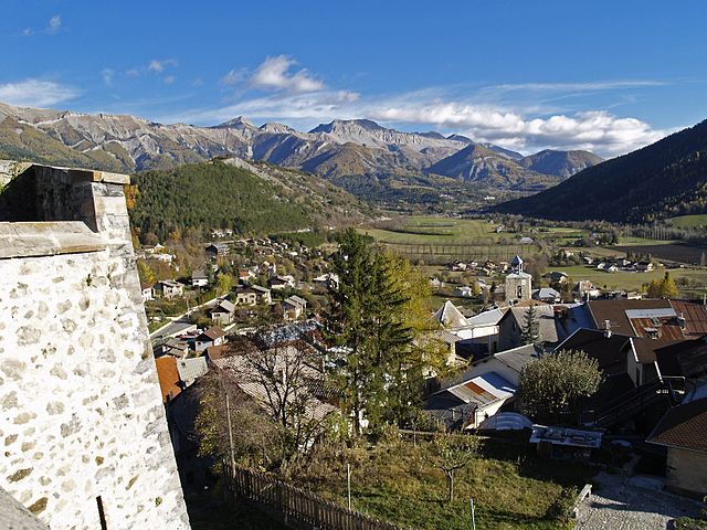
 Hiking in arrondissement of Digne-les-Bains
The Arrondissement of Digne-les-Bains, located in the Alpes-de-Haute-Provence department in southeastern France, offers a diverse range of hiking opportunities. This region is known for its stunning natural landscapes, including mountains, valleys, and stunning geological formations. Here are some highlights and tips for hiking in the area:
1.
- The region features a mix of terrain, from gentle rolling hills to more rugged mountain trails. Hikers can choose routes that match their skill level, whether they are beginners or experienced trekkers.
2.
- The Blaye Mountain Range: Offers several trails with breathtaking views of the Durance Valley. Look for trails that take you through diverse ecosystems, including forests and rocky outcrops.
- The Verdon Gorge: While just outside the immediate area, it’s a significant attraction for hiking enthusiasts. Known for its stunning turquoise river and dramatic cliffs, there are numerous trails ranging from easy walks to more challenging routes.
- Lavande Fields: In summer, hiking among the lavender fields can be an aromatic and beautiful experience, particularly around Valensole Plateau.
3.
- The Digne-les-Bains area is close to several protected natural areas, including the Mercantour National Park, which preserves diverse flora and fauna and offers extensive hiking trails with varying difficulty levels.
4.
- The region is known for its unique geological formations, including fossils and ancient marine sediment, making some hikes not only a physical challenge but also an educational experience.
5.
- Before heading out, it is essential to check the weather and trail conditions. It's advisable to carry plenty of water, snacks, and a map or GPS device. Trails are well marked, but local maps can provide additional information about points of interest and varying trail difficulties.
- Local tourism offices can provide up-to-date information on trails, guided tours, and any regulations or safety advice.
6.
- Many trails are accessible from nearby towns and villages, making it convenient to find a starting point. Digne-les-Bains itself has amenities such as food and lodging for those who wish to explore multiple days.
Conclusion
Hiking in the Arrondissement of Digne-les-Bains is an enriching experience filled with natural beauty and diverse landscapes. Whether you seek challenging hikes or leisurely strolls through picturesque countryside, the region provides numerous options to explore and enjoy the great outdoors. Always remember to respect the environment, stay on marked trails, and enjoy the adventure!
- Country:

- Capital: Digne-les-Bains
- Coordinates: 44° 6' 0" N, 6° 14' 0" E


- GPS tracks (wikiloc): [Link]
- Population: 47302
- Wikipedia en: wiki(en)
- Wikipedia: wiki(fr)
- Wikidata storage: Wikidata: Q701110
- Freebase ID: [/m/095kfn]
- INSEE arrondissement code: [043]
Includes regions:

canton of Seyne
- canton of France
Hiking in canton of Seyne
The Canton of Seyne, located in the French Alps in the Hautes-Alpes department, offers stunning landscapes and a variety of hiking opportunities that cater to different skill levels. Here are some key points about hiking in this beautiful region:...
- Country:
- Capital: Seyne
- Coordinates: 44° 21' 5" N, 6° 21' 25" E
- GPS tracks (wikiloc): [Link]
- Population: 8304

canton of Barrême
- canton of France
Hiking in canton of Barrême
The Canton of Barrême, located in the Alpes-de-Haute-Provence region of southeastern France, offers beautiful landscapes and diverse hiking opportunities. Here are some highlights and tips for hiking in the area:...

canton of Digne-les-Bains-Est
- canton of France
Hiking in canton of Digne-les-Bains-Est
The Canton of Digne-les-Bains-Est, located in the Alpes-de-Haute-Provence region of southeastern France, offers a variety of hiking opportunities that showcase stunning landscapes, diverse ecosystems, and rich cultural heritage. Here are some highlights and tips for hiking in this area:...
- Country:
- Capital: Digne-les-Bains
- Coordinates: 44° 5' 36" N, 6° 14' 11" E
- GPS tracks (wikiloc): [Link]
canton of Digne-les-Bains-Ouest
- canton of France
Hiking in canton of Digne-les-Bains-Ouest
The Canton of Digne-les-Bains-Ouest, located in the Alpes-de-Haute-Provence department of the Provence-Alpes-Côte d'Azur region in southeastern France, offers a variety of hiking opportunities for outdoor enthusiasts. The area is known for its stunning landscapes, diverse geological formations, and rich biodiversity. Here are some highlights for hikers in this region:...
- Country:
- Capital: Digne-les-Bains
- Coordinates: 44° 5' 36" N, 6° 14' 11" E
- GPS tracks (wikiloc): [Link]

canton of La Javie
- canton of France
Hiking in canton of La Javie
The Canton of La Javie, located in the Alpes-de-Haute-Provence region of France, offers a scenic and varied environment for hiking enthusiasts. This area is characterized by its stunning landscapes, including rugged mountains, lush valleys, and river gorges, allowing for a range of hiking experiences suitable for different skill levels....
- Country:
- Capital: La Javie
- Coordinates: 44° 10' 31" N, 6° 21' 7" E
- GPS tracks (wikiloc): [Link]
- Area: 306.87 sq km
- Population: 1780

canton of Moustiers-Sainte-Marie
- canton of France
Hiking in canton of Moustiers-Sainte-Marie
Hiking in the Canton of Moustiers-Sainte-Marie, located in the Alpes-de-Haute-Provence region of France, offers an array of stunning landscapes and diverse trails suitable for various skill levels. The area is renowned for its beautiful natural environment, characterized by dramatic cliffs, crystal-clear lakes, and the picturesque Verdon Gorge, one of the deepest gorges in Europe....
- Country:
- Capital: Moustiers-Sainte-Marie
- Coordinates: 43° 50' 54" N, 6° 13' 19" E
- GPS tracks (wikiloc): [Link]

canton of Mézel
- canton of France
Hiking in canton of Mézel
The Canton of Mézel, located in the Alpes-de-Haute-Provence department in southeastern France, offers a stunning backdrop for hiking enthusiasts. The region is characterized by its beautiful landscapes, including rolling hills, varied terrain, and picturesque villages. Here are some highlights for hiking in this area:...


canton of Riez
- canton of France
Hiking in canton of Riez
The Canton of Riez, located in the Provence-Alpes-Côte d'Azur region of France, offers a diverse range of hiking opportunities, characterized by its stunning landscapes, historical sites, and varied terrain. Here are some highlights:...
- Country:
- Capital: Riez
- Coordinates: 43° 49' 8" N, 6° 5' 37" E
- GPS tracks (wikiloc): [Link]
- Population: 9344


canton of Valensole
- canton of France
Hiking in canton of Valensole
The Canton of Valensole is located in the Alpes-de-Haute-Provence region of France, known for its stunning landscapes, lavender fields, and charming villages. While it may not be a major hiking destination compared to other regions, there are still some beautiful trails to explore. Here are some key points about hiking in this area:...
- Country:
- Capital: Valensole
- Coordinates: 43° 50' 20" N, 5° 59' 4" E
- GPS tracks (wikiloc): [Link]
- Population: 8643

canton of Mées
- canton of France (until March 2015)
Hiking in canton of Mées
The Canton of Les Mées, located in the Alpes-de-Haute-Provence department in southeastern France, offers a stunning setting for hiking enthusiasts. This area is known for its diverse landscapes, including rolling hills, rocky outcrops, and beautiful valleys, making it an ideal destination for outdoor activities....