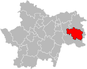
arrondissement of Louhans (arrondissement de Louhans)

- arrondissement of France
 Hiking in arrondissement of Louhans
The Arrondissement of Louhans, nestled in the Saône-et-Loire department of the Bourgogne-Franche-Comté region in France, offers a charming backdrop for hiking enthusiasts. Known for its picturesque landscapes, rich history, and cultural heritage, the area features a variety of trails that can cater to different skill levels.
Key Highlights for Hiking in Louhans:
-
Scenic Landscapes: The region showcases a mix of rolling hills, lush forests, and serene rivers. The agricultural landscapes provide a beautiful setting, especially in spring and summer when the fields are in bloom.
-
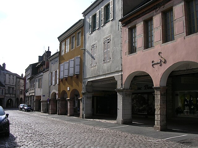
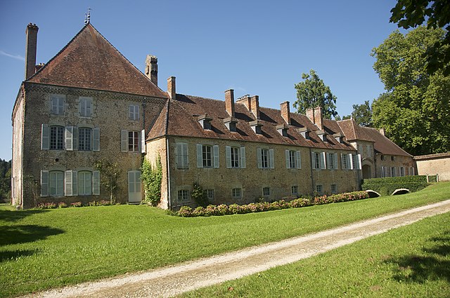
Historical Sites: While hiking, you may come across historical landmarks, such as old churches, châteaux, and traditional Burgundian farms. The town of Louhans itself is famous for its medieval architecture and the characteristic wooden arcades that line the main street.
-
Local Nature Reserves: There are nature reserves nearby, such as the Val de Saône, which offers opportunities for birdwatching and observing local wildlife while you hike.
-
Network of Trails: Various marked trails are available, ranging from easy walks suitable for families to more challenging hikes for experienced trekkers. The trails often provide information about the local flora and fauna, enhancing your outdoor experience.
-
Monuments and Cultural Sites: Along the trails, hikers can explore sites such as the Louhans Market, celebrated for its traditional local products, and the ancient village of Branges.
-
Accessibility: The area is relatively easy to access, with nearby towns serving as good starting points for hikes and providing necessary amenities.
Tips for Hiking in Louhans:
-
Seasonal Considerations: Spring and autumn are ideal for hiking, with mild temperatures and vibrant scenery. Summer can be quite warm, while winter hiking may require additional preparation due to potential cold and snow.
-
Stay Hydrated and Prepared: Bring plenty of water, snacks, appropriate clothing, and sturdy footwear, especially if venturing on longer trails.
-
Local Guidance: If you’re unfamiliar with the area, consider hiring a local guide or joining organized hiking groups to enhance your experience and ensure safety.
-
Respect Nature: As with any hiking area, remember to follow Leave No Trace principles to preserve the natural beauty and integrity of the environment.
Whether you’re looking for a relaxing day out or an adventurous hike, the Arrondissement of Louhans has something to offer for everyone. Enjoy your hiking adventures in this beautiful region!
- Country:

- Capital: Louhans
- Coordinates: 46° 40' 0" N, 5° 10' 0" E


- GPS tracks (wikiloc): [Link]
- Population: 55571
- Wikipedia en: wiki(en)
- Wikipedia: wiki(fr)
- Wikidata storage: Wikidata: Q701568
- Wikipedia Commons Category: [Link]
- Freebase ID: [/m/0955xp]
- GeoNames ID: Alt: [2997438]
- GND ID: Alt: [4776107-6]
- INSEE arrondissement code: [714]
- GNS Unique Feature ID: -1447972
Includes regions:

canton of Montpont-en-Bresse
- canton of France (until March 2015)
- Country:
- Capital: Montpont-en-Bresse
- Coordinates: 46° 34' 32" N, 5° 9' 0" E
- GPS tracks (wikiloc): [Link]


canton of Cuiseaux
- canton of France
Hiking in canton of Cuiseaux
Cuiseaux is a charming locality in the Jura department of the Bourgogne-Franche-Comté region in France. While it may not be as widely recognized as some other hiking destinations, it offers beautiful landscapes and a variety of trails suitable for hiking enthusiasts....
- Country:
- Capital: Cuiseaux
- Coordinates: 46° 30' 31" N, 5° 19' 49" E
- GPS tracks (wikiloc): [Link]
- Population: 20096
canton of Louhans
- canton of France
- Country:
- Capital: Louhans
- Coordinates: 46° 38' 28" N, 5° 13' 48" E
- GPS tracks (wikiloc): [Link]
- Population: 21139

canton of Saint-Germain-du-Bois
- canton of France (until March 2015)
- Country:
- Capital: Saint-Germain-du-Bois
- Coordinates: 46° 46' 3" N, 5° 14' 32" E
- GPS tracks (wikiloc): [Link]

canton of Beaurepaire-en-Bresse
- canton of France (until March 2015)
- Country:
- Capital: Beaurepaire-en-Bresse
- Coordinates: 46° 39' 13" N, 5° 20' 38" E
- GPS tracks (wikiloc): [Link]


canton of Pierre-de-Bresse
- canton of France
- Country:
- Capital: Pierre-de-Bresse
- Coordinates: 46° 52' 8" N, 5° 16' 17" E
- GPS tracks (wikiloc): [Link]
- Population: 16397