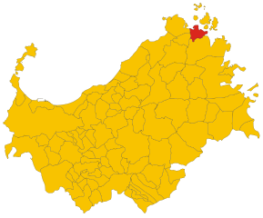
Arzachena (Arzachena)
%20-%202016.svg)
- Italian comune
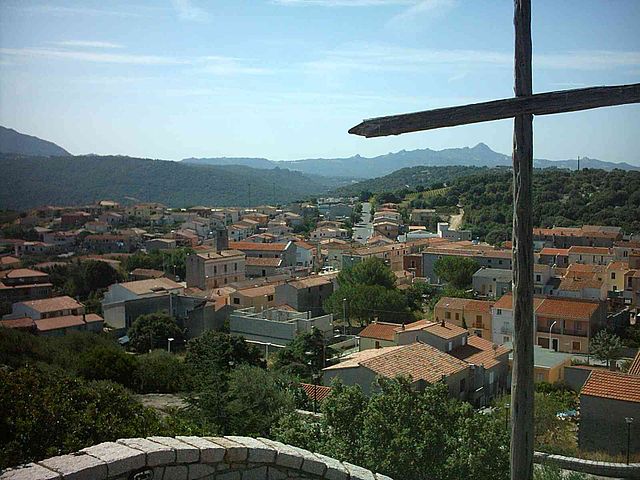
 Hiking in Arzachena
Hiking in Arzachena, a charming town located in the Gallura region of northern Sardinia, Italy, offers a unique experience filled with stunning landscapes, rich history, and diverse flora and fauna. Here are some key aspects to consider:
Trails and Routes:
- Capichera Nature Reserve: This area features various trails that take you through Mediterranean scrubland, hills, and rocky outcrops, providing chances for birdwatching and exploring local flora.
- Hiking to La Maddalena Archipelago: While Arzachena itself is inland, it serves as a great starting point for excursions to the nearby La Maddalena Archipelago, where hiking trails can be found on the main island and the surrounding small islands.
- Tiscali: This hike leads to the ancient Nuragic settlement of Tiscali, located in a scenic limestone cave. The trail is somewhat challenging but offers breathtaking views and a glimpse into Sardinia’s prehistory.
- Mount Pulchiana: For those seeking panoramic views, the trail up Mount Pulchiana is recommended, providing stunning vistas of the surrounding area, including the Costa Smeralda.
Preparing for Your Hike:
- Weather: The best time for hiking in Arzachena is during the spring (April to June) and fall (September to October) when temperatures are milder and conditions are more favorable.
- Hiking Gear: Good hiking boots, a backpack, water, snacks, and sunscreens are essential. A map or GPS device will also help you navigate the trails.
- Wildlife Watching: Keep an eye out for local wildlife, including various bird species and the unique plants of the Mediterranean ecosystem.
Safety Tips:
- Always inform someone about your hiking plans.
- Stay on marked trails to protect the environment.
- Be aware of your physical limits and choose trails that match your skill level.
Cultural Experience:
Hiking in Arzachena can also be combined with cultural experiences. After a hike, you can explore the town’s archaeological sites, such as the Nuraghe La Prisgiona and tombs of Giants. Additionally, indulge in local cuisine at nearby restaurants to enrich your experience.
Overall, hiking in Arzachena offers a blend of adventure, breathtaking scenery, and cultural exploration, making it an excellent choice for outdoor enthusiasts.
- Country:

- Postal Code: 07021; 07020
- Local Dialing Code: 0789
- Licence Plate Code: SS
- Coordinates: 41° 4' 49" N, 9° 23' 17" E


- GPS tracks (wikiloc): [Link]
- AboveSeaLevel: 85 м m
- Area: 230.85 sq km
- Population: 13756
- Web site: http://www.comunearzachena.it/
- Wikipedia en: wiki(en)
- Wikipedia: wiki(it)
- Wikidata storage: Wikidata: Q186538
- Wikipedia Commons Gallery: [Link]
- Wikipedia Commons Category: [Link]
- Freebase ID: [/m/0cxlhf]
- GeoNames ID: Alt: [6539219]
- VIAF ID: Alt: [135570583]
- OSM relation ID: [41025]
- GND ID: Alt: [4781095-6]
- MusicBrainz area ID: [23c3b9f2-3e44-48e3-90a9-610859033c25]
- Quora topic ID: [Arzachena]
- UN/LOCODE: [ITAZC]
- Digital Atlas of the Roman Empire ID: [36279]
- ISTAT ID: 090006
- Italian cadastre code: A453
Shares border with regions:


Olbia
- Italian comune
Hiking in Olbia
Olbia, located in the beautiful region of Sardinia, Italy, is well-known for its stunning landscapes, beautiful coastline, and rich cultural history, making it a great destination for hiking enthusiasts. Here are some highlights for hiking in and around Olbia:...
- Country:
- Postal Code: 07026
- Local Dialing Code: 0789
- Licence Plate Code: SS
- Coordinates: 40° 55' 0" N, 9° 30' 0" E
- GPS tracks (wikiloc): [Link]
- AboveSeaLevel: 10 м m
- Area: 383.64 sq km
- Population: 48200
- Web site: [Link]


Tempio Pausania
- Italian comune
Hiking in Tempio Pausania
Tempio Pausania, located in the northern part of Sardinia, Italy, is surrounded by picturesque landscapes, making it an excellent destination for hiking enthusiasts. The area is characterized by its unique granite formations, lush forests, and a variety of trails suitable for different hiking levels....
- Country:
- Postal Code: 07029
- Local Dialing Code: 079
- Licence Plate Code: SS
- Coordinates: 40° 54' 5" N, 9° 6' 16" E
- GPS tracks (wikiloc): [Link]
- AboveSeaLevel: 566 м m
- Area: 210.82 sq km
- Population: 13973
- Web site: [Link]

Palau
- Italian comune
Hiking in Palau
Hiking in Palau, Sardinia, offers a unique blend of breathtaking landscapes, stunning coastal views, and diverse trails that cater to various skill levels. Situated in the northeast of Sardinia, Palau serves as a gateway to the beautiful Maddalena Archipelago and features some remarkable natural scenery....
- Country:
- Postal Code: 07020
- Local Dialing Code: 0789
- Licence Plate Code: SS
- Coordinates: 41° 11' 0" N, 9° 23' 0" E
- GPS tracks (wikiloc): [Link]
- AboveSeaLevel: 5 м m
- Area: 44.44 sq km
- Population: 4224
- Web site: [Link]


Luogosanto
- Italian comune
Hiking in Luogosanto
Luogosanto is a beautiful town located in the Gallura region of Sardinia, Italy. It is known for its stunning natural landscapes, ancient history, and a variety of hiking opportunities that cater to all levels of experience. Here are some key points about hiking in the Luogosanto area:...
- Country:
- Postal Code: 07020
- Local Dialing Code: 079
- Licence Plate Code: SS
- Coordinates: 41° 3' 1" N, 9° 12' 22" E
- GPS tracks (wikiloc): [Link]
- AboveSeaLevel: 321 м m
- Area: 135.07 sq km
- Population: 1864
- Web site: [Link]


Luras
- Italian comune
Hiking in Luras
Luras, located in the beautiful region of Sardinia, Italy, is an excellent destination for hiking enthusiasts. The area is characterized by stunning landscapes, rich culture, and a variety of trails suitable for different skill levels....
- Country:
- Postal Code: 07025
- Local Dialing Code: 079
- Licence Plate Code: SS
- Coordinates: 40° 56' 9" N, 9° 10' 29" E
- GPS tracks (wikiloc): [Link]
- AboveSeaLevel: 500 м m
- Area: 87.59 sq km
- Population: 2528
- Web site: [Link]

Sant'Antonio di Gallura
- Italian comune
Hiking in Sant'Antonio di Gallura
Sant'Antonio di Gallura, located in the northern part of Sardinia, Italy, is a beautiful destination for hiking enthusiasts. The region is characterized by its stunning landscapes, rich flora and fauna, and a rugged coastline. Here are some highlights and tips for hiking in this area:...
- Country:
- Postal Code: 07030
- Local Dialing Code: 079
- Licence Plate Code: SS
- Coordinates: 40° 59' 31" N, 9° 18' 6" E
- GPS tracks (wikiloc): [Link]
- AboveSeaLevel: 354 м m
- Area: 81.69 sq km
- Population: 1502
- Web site: [Link]