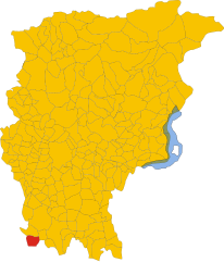
Arzago d'Adda (Arzago d'Adda)
- Italian comune
Arzago d'Adda is a small town in the Lombardy region of Italy, located along the Adda River. While it may not be one of the most widely recognized hiking destinations, it can offer some lovely outdoor experiences, especially for those looking to explore the scenic countryside and the riverbanks.
Hiking Opportunities:
-
Adda River Path: The area around the Adda River features several walking trails that follow the river's course. This makes for picturesque views and opportunities for birdwatching and enjoying local flora.
-
Countryside Trails: The surrounding countryside boasts various paths that pass through fields, woodlands, and small villages. These trails can provide a more serene hiking experience, allowing you to immerse yourself in nature.
-
Nearby Natural Reserves: Consider exploring adjacent natural reserves, like the "Parco Adda Nord," which offers extensive hiking paths and allows for observation of the diverse ecosystems along the river.
-
Cultural and Historical Hiking: While hiking, you may encounter historical landmarks, including old churches and mills along the river, which can enrich your hiking experience with a cultural touch.
Tips for Hiking in Arzago d'Adda:
- Weather Check: Always check the weather forecast before heading out, as conditions can change rapidly.
- Hydration and Snacks: Carry enough water and snacks, especially if you plan to hike longer trails.
- Proper Footwear: Wear sturdy hiking shoes suitable for varying terrain.
- Trail Maps: Download maps or use local guides, as not all trails may be well-marked. Local tourism offices can provide useful information on trails and conditions.
Local Considerations:
- Respect Nature: Follow Leave No Trace principles to ensure the preservation of the natural environment.
- Local Regulations: Be aware of any specific regulations or trail guidelines in the area you plan to hike.
While Arzago d'Adda may not be a primary hiking destination, its proximity to the Adda River and beautiful landscapes makes it a charming place for outdoor activities. Enjoy your hike!
- Country:

- Postal Code: 24040
- Local Dialing Code: 0363
- Licence Plate Code: BG
- Coordinates: 45° 28' 55" N, 9° 33' 48" E


- GPS tracks (wikiloc): [Link]
- AboveSeaLevel: 106 м m
- Area: 9.31 sq km
- Population: 2715
- Web site: http://www.comune.arzago.bg.it/
- Wikipedia en: wiki(en)
- Wikipedia: wiki(it)
- Wikidata storage: Wikidata: Q95075
- Wikipedia Commons Gallery: [Link]
- Wikipedia Commons Category: [Link]
- Freebase ID: [/m/0gj8l1]
- GeoNames ID: Alt: [6543141]
- OSM relation ID: [45068]
- UN/LOCODE: [ITAZ8]
- ISTAT ID: 016013
- Italian cadastre code: A440
Shares border with regions:


Calvenzano
- Italian comune
Calvenzano, located in the province of Bergamo in northern Italy, is a charming area that offers beautiful landscapes and several hiking opportunities. While it's not as well-known as some of the larger national parks in Italy, it does provide a peaceful escape into nature and a chance to explore the surrounding countryside....
- Country:

- Postal Code: 24040
- Local Dialing Code: 0363
- Licence Plate Code: BG
- Coordinates: 45° 29' 42" N, 9° 35' 58" E


- GPS tracks (wikiloc): [Link]
- AboveSeaLevel: 114 м m
- Area: 6.72 sq km
- Population: 4240
- Web site: [Link]


Casirate d'Adda
- Italian comune
Casirate d'Adda is a charming town located in the province of Bergamo in Lombardy, Italy. While it may not be as famous for hiking as some of the larger national parks or mountainous regions in the area, there are still opportunities for outdoor activities and enjoying nature in and around the town....
- Country:

- Postal Code: 24040
- Local Dialing Code: 0363
- Licence Plate Code: BG
- Coordinates: 45° 30' 0" N, 9° 34' 0" E


- GPS tracks (wikiloc): [Link]
- AboveSeaLevel: 114 м m
- Area: 10.17 sq km
- Population: 4120
- Web site: [Link]


Rivolta d'Adda
- Italian comune
Rivolta d'Adda is a charming town located in the Lombardy region of Italy, near the Adda River. While it may not be as well-known for hiking as some other destinations in Italy, it offers a variety of outdoor activities and scenic trails that are ideal for those looking to enjoy nature....
- Country:

- Postal Code: 26027
- Local Dialing Code: 0363
- Licence Plate Code: CR
- Coordinates: 45° 28' 0" N, 9° 31' 0" E


- GPS tracks (wikiloc): [Link]
- AboveSeaLevel: 101 м m
- Area: 30.4 sq km
- Population: 8133
- Web site: [Link]


Vailate
- Italian comune
Vailate, a charming village located in the Lombardy region of Italy, offers unique hiking opportunities that take advantage of its beautiful natural surroundings. While the village itself may not boast extensive hiking trails, it is situated near various natural attractions and paths in the wider area of the province of Cremona and beyond....
- Country:

- Postal Code: 26019
- Local Dialing Code: 0363
- Licence Plate Code: CR
- Coordinates: 45° 28' 0" N, 9° 36' 0" E


- GPS tracks (wikiloc): [Link]
- AboveSeaLevel: 105 м m
- Area: 9.69 sq km
- Population: 4574
- Web site: [Link]
Agnadello
- Italian comune
Agnadello, a small town in the Lombardy region of northern Italy, is not traditionally known as a hiking destination. However, that doesn't mean you can't enjoy nature and some outdoor activities in and around the area. Here are a few things to consider when hiking near Agnadello:...
- Country:

- Postal Code: 26020
- Local Dialing Code: 0373
- Licence Plate Code: CR
- Coordinates: 45° 27' 0" N, 9° 34' 0" E


- GPS tracks (wikiloc): [Link]
- AboveSeaLevel: 94 м m
- Area: 12.08 sq km
- Population: 3872
- Web site: [Link]

