Asnières-lès-Dijon (Asnières-lès-Dijon)

- commune in Côte-d'Or, France
- Country:

- Postal Code: 21380
- Coordinates: 47° 23' 6" N, 5° 2' 41" E


- GPS tracks (wikiloc): [Link]
- AboveSeaLevel: 330 м m
- Area: 4.55 sq km
- Population: 1165
- Web site: http://www.val-de-norge.fr/asnieres-les-dijon
- Wikipedia en: wiki(en)
- Wikipedia: wiki(fr)
- Wikidata storage: Wikidata: Q46390
- Wikipedia Commons Category: [Link]
- Freebase ID: [/m/03ckqsb]
- GeoNames ID: Alt: [3036566]
- SIREN number: [212100275]
- MusicBrainz area ID: [b312abaf-6d02-49ad-9828-7b53ede1cc23]
- INSEE municipality code: 21027
Shares border with regions:


Ahuy
- commune in Côte-d'Or, France
- Country:
- Postal Code: 21121
- Coordinates: 47° 22' 8" N, 5° 1' 20" E
- GPS tracks (wikiloc): [Link]
- Area: 6.4 sq km
- Population: 1184


Bellefond
- commune in Côte-d'Or, France
- Country:
- Postal Code: 21490
- Coordinates: 47° 22' 47" N, 5° 4' 11" E
- GPS tracks (wikiloc): [Link]
- Area: 2.47 sq km
- Population: 847

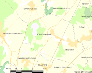
Norges-la-Ville
- commune in Côte-d'Or, France
- Country:
- Postal Code: 21490
- Coordinates: 47° 24' 28" N, 5° 4' 37" E
- GPS tracks (wikiloc): [Link]
- Area: 11 sq km
- Population: 940


Messigny-et-Vantoux
- commune in Côte-d'Or, France
- Country:
- Postal Code: 21380
- Coordinates: 47° 24' 21" N, 5° 1' 3" E
- GPS tracks (wikiloc): [Link]
- AboveSeaLevel: 310 м m
- Area: 33.92 sq km
- Population: 1628
- Web site: [Link]
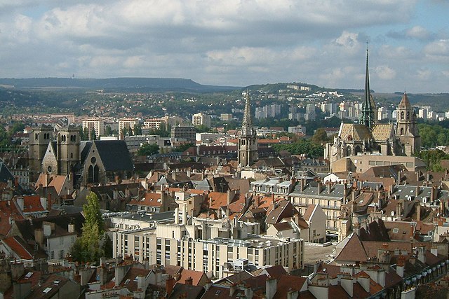

Dijon
- commune in Côte-d'Or, France
- Country:
- Postal Code: 21100; 21000
- Coordinates: 47° 19' 23" N, 5° 2' 31" E
- GPS tracks (wikiloc): [Link]
- AboveSeaLevel: 410 м m
- Area: 40.41 sq km
- Population: 155114
- Web site: [Link]