Augerville-la-Rivière (Augerville-la-Rivière)

- commune in Loiret, France
- Country:

- Postal Code: 45330
- Coordinates: 48° 15' 7" N, 2° 26' 11" E


- GPS tracks (wikiloc): [Link]
- Area: 4.03 sq km
- Population: 234
- Wikipedia en: wiki(en)
- Wikipedia: wiki(fr)
- Wikidata storage: Wikidata: Q760413
- Wikipedia Commons Category: [Link]
- Freebase ID: [/m/03nwfhd]
- GeoNames ID: Alt: [3036196]
- SIREN number: [214500134]
- BnF ID: [15260406m]
- PACTOLS thesaurus ID: [pcrtXcpN7NI2lS]
- WOEID: [577197]
- INSEE municipality code: 45013
Shares border with regions:
Labrosse
- former commune in Loiret, France
- Country:
- Postal Code: 45330
- Coordinates: 48° 14' 39" N, 2° 23' 32" E
- GPS tracks (wikiloc): [Link]
- Area: 4.09 sq km
- Population: 93


Boulancourt
- commune in Seine-et-Marne, France
- Country:
- Postal Code: 77760
- Coordinates: 48° 15' 31" N, 2° 26' 15" E
- GPS tracks (wikiloc): [Link]
- Area: 6.44 sq km
- Population: 366

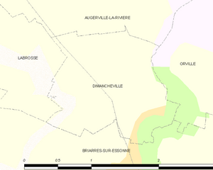
Dimancheville
- commune in Loiret, France
- Country:
- Postal Code: 45390
- Coordinates: 48° 14' 7" N, 2° 25' 50" E
- GPS tracks (wikiloc): [Link]
- Area: 2.35 sq km
- Population: 120
Orville
- commune in Loiret, France
- Country:
- Postal Code: 45390
- Coordinates: 48° 14' 32" N, 2° 26' 18" E
- GPS tracks (wikiloc): [Link]
- Area: 7.19 sq km
- Population: 117