Orville (Orville)

- commune in Loiret, France
- Country:

- Postal Code: 45390
- Coordinates: 48° 14' 32" N, 2° 26' 18" E


- GPS tracks (wikiloc): [Link]
- Area: 7.19 sq km
- Population: 117
- Wikipedia en: wiki(en)
- Wikipedia: wiki(fr)
- Wikidata storage: Wikidata: Q686426
- Wikipedia Commons Category: [Link]
- Freebase ID: [/m/03nwjwn]
- GeoNames ID: Alt: [6613563]
- SIREN number: [214502379]
- BnF ID: [15260629t]
- PACTOLS thesaurus ID: [pcrt6GNZNfuVnH]
- INSEE municipality code: 45237
Shares border with regions:


Desmonts
- commune in Loiret, France
- Country:
- Postal Code: 45390
- Coordinates: 48° 13' 35" N, 2° 29' 49" E
- GPS tracks (wikiloc): [Link]
- Area: 4.76 sq km
- Population: 168


Briarres-sur-Essonne
- commune in Loiret, France
- Country:
- Postal Code: 45390
- Coordinates: 48° 13' 42" N, 2° 25' 39" E
- GPS tracks (wikiloc): [Link]
- Area: 8.23 sq km
- Population: 531


Boulancourt
- commune in Seine-et-Marne, France
- Country:
- Postal Code: 77760
- Coordinates: 48° 15' 31" N, 2° 26' 15" E
- GPS tracks (wikiloc): [Link]
- Area: 6.44 sq km
- Population: 366

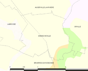
Dimancheville
- commune in Loiret, France
- Country:
- Postal Code: 45390
- Coordinates: 48° 14' 7" N, 2° 25' 50" E
- GPS tracks (wikiloc): [Link]
- Area: 2.35 sq km
- Population: 120
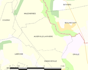
Augerville-la-Rivière
- commune in Loiret, France
- Country:
- Postal Code: 45330
- Coordinates: 48° 15' 7" N, 2° 26' 11" E
- GPS tracks (wikiloc): [Link]
- Area: 4.03 sq km
- Population: 234


Puiseaux
- commune in Loiret, France
- Country:
- Postal Code: 45390
- Coordinates: 48° 12' 19" N, 2° 28' 16" E
- GPS tracks (wikiloc): [Link]
- Area: 20.32 sq km
- Population: 3385
- Web site: [Link]

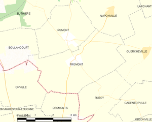
Fromont
- commune in Seine-et-Marne, France
- Country:
- Postal Code: 77760
- Coordinates: 48° 15' 20" N, 2° 30' 14" E
- GPS tracks (wikiloc): [Link]
- Area: 10.72 sq km
- Population: 226