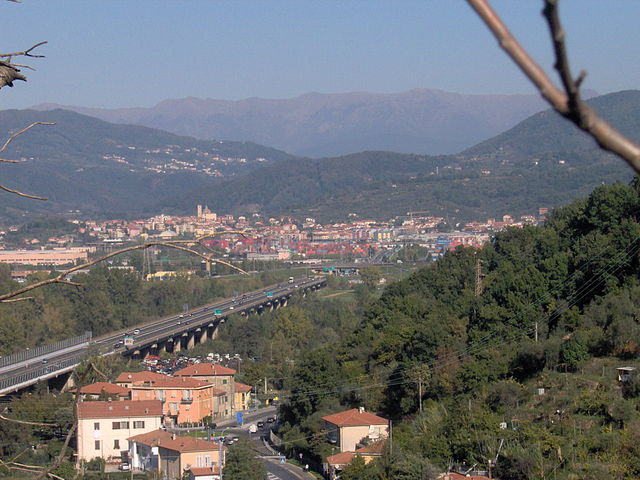
Aulla (Aulla)
.svg)
- Italian comune
 Hiking in Aulla
Aulla is a charming town located in the Lunigiana region of Tuscany, Italy. Surrounded by lush hills and situated near the Magra River, Aulla serves as an excellent base for various hiking adventures in the area. Here are some highlights and tips for hiking in and around Aulla:
Hiking Trails
-
Paths Along the Magra River: Many trails stretch along the Magra River, offering scenic views of the riverbanks and surrounding hills. These paths are generally accessible to hikers of all skill levels.
-
Via Francigena: This historic pilgrim route runs through the region, and sections of it can be walked from Aulla. It provides a blend of cultural heritage and beautiful landscapes.
-
Montalto: The route to Montalto offers a more challenging hike. The trail takes you to the summit of this mountain, rewarding hikers with panoramic views of the surrounding area, including the Apuan Alps and the Apennines.
-
Castles and Villages: Consider combining hikes with visits to historical sites. There are trails that connect Aulla to nearby medieval villages and castles, making it possible to enjoy both nature and culture.
Tips for Hiking in Aulla
- Best Time to Hike: Spring (April to June) and autumn (September to October) are ideal for hiking, as the weather is mild and pleasant.
- Safety and Preparation: Always carry enough water, snacks, and a basic first-aid kit. Check the weather forecast before embarking on a hike.
- Footwear: Wear sturdy hiking boots with good grip, as trails can vary in difficulty and terrain.
- Navigation: Familiarize yourself with the trails or take a map/app with you. Local tourist information centers can provide useful guidance and trail maps.
- Local Knowledge: Engage with local hiking groups or guides for insider knowledge on the best routes and hidden gems in the area.
Additional Attractions
While hiking, don’t miss the opportunity to explore Aulla itself. The town features interesting historical architecture, including the Castle of Aulla and several churches. After a day of hiking, you can enjoy local cuisine at one of the town’s restaurants, sampling the flavors of Tuscany.
Whether you're an experienced hiker or a casual walker, Aulla offers a great mix of natural beauty and historical exploration. Enjoy your hiking adventures!
- Country:

- Postal Code: 54011
- Local Dialing Code: 0187
- Licence Plate Code: MS
- Coordinates: 44° 13' 0" N, 9° 58' 0" E


- GPS tracks (wikiloc): [Link]
- AboveSeaLevel: 64 м m
- Area: 59.99 sq km
- Population: 11092
- Web site: http://www.comuni-italiani.it/045/001/
- Wikipedia en: wiki(en)
- Wikipedia: wiki(it)
- Wikidata storage: Wikidata: Q52227
- Wikipedia Commons Gallery: [Link]
- Wikipedia Commons Category: [Link]
- Freebase ID: [/m/0fytj5]
- GeoNames ID: Alt: [6541878]
- VIAF ID: Alt: [160360470]
- OSM relation ID: [42922]
- GND ID: Alt: [4406044-0]
- MusicBrainz area ID: [6c29ac90-f834-46ad-9154-7a80a784bec7]
- TGN ID: [7006245]
- UN/LOCODE: [ITAUA]
- Gran Enciclopèdia Catalana ID: [0263772]
- ISTAT ID: 045001
- Italian cadastre code: A496
Shares border with regions:


Sarzana
- Italian comune
Hiking in Sarzana
Hiking in Sarzana, located in the picturesque region of Liguria in Italy, offers a unique blend of coastal and mountainous landscapes. This charming town is situated near the Apuan Alps and the stunning coastline of the Italian Riviera, making it an excellent base for various outdoor activities, including hiking....
- Country:
- Postal Code: 19038
- Local Dialing Code: 0187
- Licence Plate Code: SP
- Coordinates: 44° 6' 49" N, 9° 57' 36" E
- GPS tracks (wikiloc): [Link]
- AboveSeaLevel: 21 м m
- Area: 34.52 sq km
- Population: 22133
- Web site: [Link]


Bolano
- Italian comune
Hiking in Bolano
Bolano, a charming town in the Liguria region of Italy, is surrounded by beautiful landscapes that make it an excellent destination for hiking enthusiasts. The area boasts a variety of trails that cater to different skill levels, from leisurely walks to challenging hikes, offering stunning views of the surrounding hills, vineyards, and the nearby Cinque Terre National Park....
- Country:
- Postal Code: 19020
- Local Dialing Code: 0187
- Licence Plate Code: SP
- Coordinates: 44° 11' 21" N, 9° 53' 43" E
- GPS tracks (wikiloc): [Link]
- AboveSeaLevel: 317 м m
- Area: 14.57 sq km
- Population: 7836
- Web site: [Link]

Santo Stefano di Magra
- Italian comune
Hiking in Santo Stefano di Magra
Santo Stefano di Magra is a charming town located in the Liguria region of Italy, nestled near the foothills of the Apuan Alps and the beautiful Cinque Terre National Park. Its strategic position makes it a great starting point for various hiking trails that offer stunning views of the surrounding landscapes....
- Country:
- Postal Code: 19037
- Local Dialing Code: 0187
- Licence Plate Code: SP
- Coordinates: 44° 9' 45" N, 9° 54' 54" E
- GPS tracks (wikiloc): [Link]
- AboveSeaLevel: 54 м m
- Area: 13.85 sq km
- Population: 9613
- Web site: [Link]


Fivizzano
- Italian comune
Hiking in Fivizzano
Fivizzano, located in the Lunigiana region of Tuscany, Italy, is a fantastic destination for hiking enthusiasts. The area is characterized by its stunning natural landscapes, rich history, and charming medieval towns....
- Country:
- Postal Code: 54013
- Local Dialing Code: 0585
- Licence Plate Code: MS
- Coordinates: 44° 14' 0" N, 10° 7' 0" E
- GPS tracks (wikiloc): [Link]
- AboveSeaLevel: 332 м m
- Area: 180.57 sq km
- Population: 7838
- Web site: [Link]


Fosdinovo
- Italian comune
Hiking in Fosdinovo
Fosdinovo, located in the province of Massa-Carrara in Tuscany, Italy, is a charming village rich in history and surrounded by stunning natural scenery, making it an excellent destination for hiking enthusiasts. Here are some highlights and important information for hiking in Fosdinovo:...
- Country:
- Postal Code: 54030; 54035
- Local Dialing Code: 0187
- Licence Plate Code: MS
- Coordinates: 44° 8' 0" N, 10° 1' 0" E
- GPS tracks (wikiloc): [Link]
- AboveSeaLevel: 550 м m
- Area: 48.71 sq km
- Population: 4792
- Web site: [Link]


Licciana Nardi
- Italian comune
Hiking in Licciana Nardi
Licciana Nardi is a charming village located in the Toscana region of Italy, nestled in the Apuan Alps. This area is known for its stunning natural scenery, rich history, and various hiking opportunities that cater to all skill levels....
- Country:
- Postal Code: 54016
- Local Dialing Code: 0187
- Licence Plate Code: MS
- Coordinates: 44° 16' 0" N, 10° 2' 0" E
- GPS tracks (wikiloc): [Link]
- AboveSeaLevel: 210 м m
- Area: 55.68 sq km
- Population: 4918
- Web site: [Link]


Podenzana
- Italian comune
Hiking in Podenzana
Podenzana is a charming village located in the province of Massa-Carrara in Tuscany, Italy. Surrounded by the beautiful Apuan Alps and nestled in the Apennine Mountains, it offers a variety of hiking opportunities with stunning views and picturesque landscapes....
- Country:
- Postal Code: 54010
- Local Dialing Code: 0187
- Licence Plate Code: MS
- Coordinates: 44° 12' 0" N, 9° 57' 0" E
- GPS tracks (wikiloc): [Link]
- AboveSeaLevel: 312 м m
- Area: 17.1 sq km
- Population: 2175
- Web site: [Link]