Ausson (Ausson)

- commune in Haute-Garonne, France
- Country:

- Postal Code: 31210
- Coordinates: 43° 4' 54" N, 0° 35' 45" E


- GPS tracks (wikiloc): [Link]
- Area: 4.39 sq km
- Population: 575
- Wikipedia en: wiki(en)
- Wikipedia: wiki(fr)
- Wikidata storage: Wikidata: Q1148546
- Wikipedia Commons Category: [Link]
- Freebase ID: [/m/03nsy1f]
- Freebase ID: [/m/03nsy1f]
- GeoNames ID: Alt: [6448256]
- GeoNames ID: Alt: [6448256]
- SIREN number: [213100316]
- SIREN number: [213100316]
- BnF ID: [15255027g]
- BnF ID: [15255027g]
- INSEE municipality code: 31031
- INSEE municipality code: 31031
Shares border with regions:

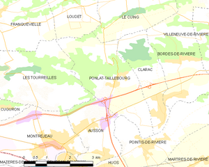
Ponlat-Taillebourg
- commune in Haute-Garonne, France
- Country:
- Postal Code: 31210
- Coordinates: 43° 6' 41" N, 0° 35' 59" E
- GPS tracks (wikiloc): [Link]
- Area: 8.6 sq km
- Population: 630

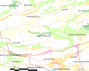
Les Tourreilles
- commune in Haute-Garonne, France
- Country:
- Postal Code: 31210
- Coordinates: 43° 6' 46" N, 0° 33' 7" E
- GPS tracks (wikiloc): [Link]
- AboveSeaLevel: 547 м m
- Area: 12.33 sq km
- Population: 385

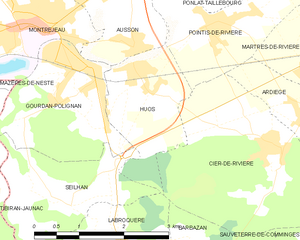
Huos
- commune in Haute-Garonne, France
- Country:
- Postal Code: 31210
- Coordinates: 43° 4' 42" N, 0° 35' 46" E
- GPS tracks (wikiloc): [Link]
- Area: 4.09 sq km
- Population: 489


Montréjeau
- commune in Haute-Garonne, France
- Country:
- Postal Code: 31210
- Coordinates: 43° 5' 5" N, 0° 34' 8" E
- GPS tracks (wikiloc): [Link]
- Area: 8.21 sq km
- Population: 2863
- Web site: [Link]


Gourdan-Polignan
- commune in Haute-Garonne, France
- Country:
- Postal Code: 31210
- Coordinates: 43° 4' 40" N, 0° 34' 38" E
- GPS tracks (wikiloc): [Link]
- AboveSeaLevel: 523 м m
- Area: 5.26 sq km
- Population: 1215
- Web site: [Link]

Pointis-de-Rivière
- commune in Haute-Garonne, France
- Country:
- Postal Code: 31210
- Coordinates: 43° 5' 13" N, 0° 37' 3" E
- GPS tracks (wikiloc): [Link]
- Area: 6.58 sq km
- Population: 849