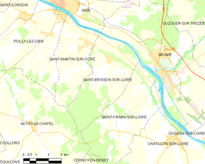
Autry-le-Châtel (Autry-le-Châtel)

- commune in Loiret, France
- Country:

- Postal Code: 45500
- Coordinates: 47° 35' 51" N, 2° 36' 8" E


- GPS tracks (wikiloc): [Link]
- AboveSeaLevel: 185 м m
- Area: 50.56 sq km
- Population: 973
- Wikipedia en: wiki(en)
- Wikipedia: wiki(fr)
- Wikidata storage: Wikidata: Q1167882
- Wikipedia Commons Category: [Link]
- Freebase ID: [/m/03nwfjs]
- GeoNames ID: Alt: [6449129]
- SIREN number: [214500167]
- BnF ID: [15260409n]
- PACTOLS thesaurus ID: [pcrt5gAEA0QS5f]
- INSEE municipality code: 45016
Shares border with regions:
Cernoy-en-Berry
- commune in Loiret, France
- Country:
- Postal Code: 45360
- Coordinates: 47° 32' 24" N, 2° 39' 40" E
- GPS tracks (wikiloc): [Link]
- Area: 28.23 sq km
- Population: 459

Saint-Brisson-sur-Loire
- commune in Loiret, France
- Country:
- Postal Code: 45500
- Coordinates: 47° 38' 52" N, 2° 40' 59" E
- GPS tracks (wikiloc): [Link]
- Area: 21.86 sq km
- Population: 996

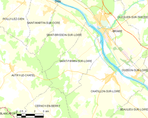
Saint-Firmin-sur-Loire
- commune in Loiret, France
- Country:
- Postal Code: 45360
- Coordinates: 47° 37' 33" N, 2° 43' 56" E
- GPS tracks (wikiloc): [Link]
- Area: 24.76 sq km
- Population: 547

Coullons
- commune in Loiret, France
- Country:
- Postal Code: 45720
- Coordinates: 47° 37' 14" N, 2° 29' 33" E
- GPS tracks (wikiloc): [Link]
- Area: 78.97 sq km
- Population: 2489
- Web site: [Link]


Saint-Martin-sur-Ocre
- commune in Loiret, France
- Country:
- Postal Code: 45500
- Coordinates: 47° 39' 33" N, 2° 39' 30" E
- GPS tracks (wikiloc): [Link]
- Area: 15.79 sq km
- Population: 1231

Blancafort
- commune in Cher, France
- Country:
- Postal Code: 18410
- Coordinates: 47° 31' 57" N, 2° 31' 50" E
- GPS tracks (wikiloc): [Link]
- Area: 64.35 sq km
- Population: 1064


Poilly-lez-Gien
- commune in Loiret, France
- Country:
- Postal Code: 45500
- Coordinates: 47° 40' 40" N, 2° 35' 56" E
- GPS tracks (wikiloc): [Link]
- Area: 33.29 sq km
- Population: 2403