Avesnes-en-Saosnois (Avesnes-en-Saosnois)

- commune in Sarthe, France
- Country:

- Postal Code: 72260
- Coordinates: 48° 15' 48" N, 0° 22' 16" E


- GPS tracks (wikiloc): [Link]
- Area: 5.68 sq km
- Population: 89
- Wikipedia en: wiki(en)
- Wikipedia: wiki(fr)
- Wikidata storage: Wikidata: Q1223917
- Wikipedia Commons Category: [Link]
- Freebase ID: [/m/03qj0kf]
- GeoNames ID: Alt: [6617551]
- SIREN number: [217200187]
- BnF ID: [15273577b]
- INSEE municipality code: 72018
Shares border with regions:

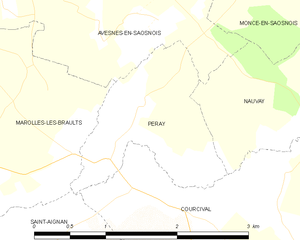
Peray
- commune in Sarthe, France
- Country:
- Postal Code: 72260
- Coordinates: 48° 14' 54" N, 0° 21' 51" E
- GPS tracks (wikiloc): [Link]
- Area: 2.45 sq km
- Population: 65


Moncé-en-Saosnois
- commune in Sarthe, France
- Country:
- Postal Code: 72260
- Coordinates: 48° 16' 29" N, 0° 23' 20" E
- GPS tracks (wikiloc): [Link]
- Area: 8.81 sq km
- Population: 257


Nauvay
- commune in Sarthe, France
- Country:
- Postal Code: 72260
- Coordinates: 48° 15' 7" N, 0° 23' 39" E
- GPS tracks (wikiloc): [Link]
- Area: 2.71 sq km
- Population: 11


Marolles-les-Braults
- commune in Sarthe, France
- Country:
- Postal Code: 72260
- Coordinates: 48° 15' 8" N, 0° 18' 51" E
- GPS tracks (wikiloc): [Link]
- Area: 20.64 sq km
- Population: 2067
- Web site: [Link]


Monhoudou
- commune in Sarthe, France
- Country:
- Postal Code: 72260
- Coordinates: 48° 17' 12" N, 0° 19' 31" E
- GPS tracks (wikiloc): [Link]
- Area: 7.52 sq km
- Population: 218