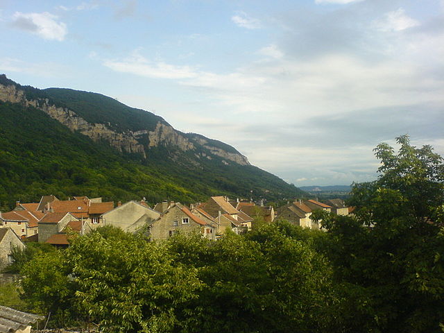
Bénonces (Bénonces)
- commune in Ain, France
 Hiking in Bénonces
Bénonces, a lesser-known area for hiking, is blessed with natural beauty and a variety of trails that cater to different skill levels. While specific details about Bénonces might not be widely documented, you can generally expect the following when hiking in similar regions:
-
Scenic Trails: Look for trails that offer stunning views of local landscapes, whether it's mountains, forests, or rivers. These can give you a rewarding experience, especially if you’re a fan of photography or birdwatching.
-
Trail Variety: Many regions have a mix of easy, moderate, and challenging trails. Be sure to assess your fitness level and choose hikes that are suitable for you. Family-friendly paths often exist alongside more rugged options.
-
Wildlife: Hiking in Bénonces could offer opportunities to spot local wildlife. Bring binoculars if you're keen on observing animals in their natural habitat.
-
Best Seasons: The best time to hike will often depend on the climate. Generally, spring and fall offer mild weather and beautiful foliage, while summer can be warm and winter could offer unique snowy landscapes for those who enjoy winter hiking.
-
Local Regulations: Always check if there are any specific regulations for the area, such as trail closures, parking fees, or necessary permits.
-
Preparation: Bring appropriate gear, including sturdy shoes, enough water, and snacks. Some trails may also require trekking poles, especially if they are steep or rocky.
-
Safety: Always inform someone of your hiking plans, carry a map or GPS device, and know your limits. It’s also wise to familiarize yourself with the local flora and fauna, particularly any plants or animals that could be harmful.
If you're planning a hiking trip to Bénonces, I recommend doing further research on local hiking guides or websites for detailed trail information, topographic maps, and the best routes for your experience level!
- Country:

- Postal Code: 01470
- Coordinates: 45° 49' 40" N, 5° 28' 31" E


- GPS tracks (wikiloc): [Link]
- Area: 15.33 sq km
- Population: 288
- Web site: http://www.benonces.com
- Wikipedia en: wiki(en)
- Wikipedia: wiki(fr)
- Wikidata storage: Wikidata: Q210920
- Wikipedia Commons Category: [Link]
- Wikipedia Commons Maps Category: [Link]
- Freebase ID: [/m/07tp9b]
- Freebase ID: [/m/07tp9b]
- GeoNames ID: Alt: [6446383]
- GeoNames ID: Alt: [6446383]
- SIREN number: [210100376]
- SIREN number: [210100376]
- VIAF ID: Alt: [141009550]
- VIAF ID: Alt: [141009550]
- Library of Congress authority ID: Alt: [no2001046622]
- Library of Congress authority ID: Alt: [no2001046622]
- INSEE municipality code: 01037
- INSEE municipality code: 01037
Shares border with regions:

Conand
- commune in Ain, France
Hiking in Conand
Conand, located in the Ain department in the Auvergne-Rhône-Alpes region of France, offers a picturesque setting for hiking enthusiasts. While Conand itself is a small commune, it is surrounded by beautiful landscapes, including rolling hills, forests, and nearby mountains....
- Country:
- Postal Code: 01230
- Coordinates: 45° 53' 33" N, 5° 28' 16" E
- GPS tracks (wikiloc): [Link]
- Area: 15.28 sq km
- Population: 118

Lompnas
- commune in Ain, France
Hiking in Lompnas
Lompnas is not a well-known hiking destination, so it's possible you might be referring to a specific trail or area that goes by a different name, or it may be a less documented location. If you meant a different region or if there's a specific trail you have in mind, feel free to provide more details!...
- Country:
- Postal Code: 01680
- Coordinates: 45° 48' 11" N, 5° 31' 13" E
- GPS tracks (wikiloc): [Link]
- Area: 12.69 sq km
- Population: 167
- Web site: [Link]

Souclin
- commune in Ain, France
Hiking in Souclin
Souclin is a picturesque commune located in the Jura department of eastern France. While it may not be widely known as a hiking destination, the surrounding Jura Mountains offer a variety of trails that cater to different skill levels. Here's what you can expect when hiking in and around Souclin:...
- Country:
- Postal Code: 01150
- Coordinates: 45° 52' 34" N, 5° 25' 6" E
- GPS tracks (wikiloc): [Link]
- Area: 13.19 sq km
- Population: 267

Seillonnaz
- commune in Ain, France
Hiking in Seillonnaz
Seillonnaz is a small commune located in the Auvergne-Rhône-Alpes region of France, surrounded by lovely natural landscapes that make it a great destination for hiking enthusiasts. Here are some highlights and tips for hiking in the area:...
- Country:
- Postal Code: 01470
- Coordinates: 45° 48' 24" N, 5° 29' 25" E
- GPS tracks (wikiloc): [Link]
- Area: 9.59 sq km
- Population: 138
Villebois
- commune in Ain, France
Hiking in Villebois
Villebois is a charming commune located in the Drome region of southeastern France. It's known for its picturesque landscapes, rolling hills, and historical sites, making it an inviting destination for hikers....
- Country:
- Postal Code: 01150
- Coordinates: 45° 50' 52" N, 5° 26' 6" E
- GPS tracks (wikiloc): [Link]
- Area: 14.46 sq km
- Population: 1167
- Web site: [Link]

Montagnieu
- commune in Ain, France
Hiking in Montagnieu
Montagnieu, located in the Ain department of the Auvergne-Rhône-Alpes region in France, is a delightful destination for hiking enthusiasts. The area is characterized by its scenic landscapes, rolling hills, forested areas, and impressive views of the surrounding mountains....
- Country:
- Postal Code: 01470
- Coordinates: 45° 47' 38" N, 5° 28' 3" E
- GPS tracks (wikiloc): [Link]
- Area: 6.22 sq km
- Population: 598

Ordonnaz
- commune in Ain, France
Hiking in Ordonnaz
Ordonnaz is a small commune located in the Auvergne-Rhône-Alpes region of southeastern France, nestled at the foot of the Alps. This area offers picturesque landscapes, making it a delightful destination for hiking enthusiasts....
- Country:
- Postal Code: 01510
- Coordinates: 45° 50' 14" N, 5° 32' 18" E
- GPS tracks (wikiloc): [Link]
- Area: 14.88 sq km
- Population: 152

Serrières-de-Briord
- commune in Ain, France
Hiking in Serrières-de-Briord
Serrières-de-Briord is a charming commune located in the Ain department of the Auvergne-Rhône-Alpes region in France. This area features beautiful landscapes that are perfect for hiking enthusiasts. Here are some key points to consider when planning a hiking trip in Serrières-de-Briord:...
- Country:
- Postal Code: 01470
- Coordinates: 45° 48' 29" N, 5° 27' 16" E
- GPS tracks (wikiloc): [Link]
- Area: 8.03 sq km
- Population: 1278
- Web site: [Link]