Serrières-de-Briord (Serrières-de-Briord)
- commune in Ain, France
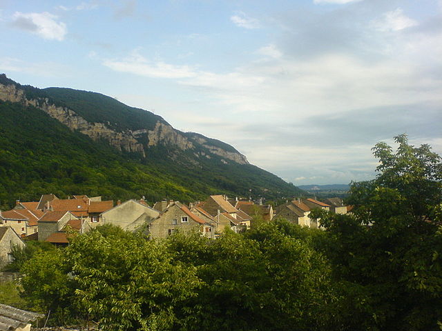
 Hiking in Serrières-de-Briord
Serrières-de-Briord is a charming commune located in the Ain department of the Auvergne-Rhône-Alpes region in France. This area features beautiful landscapes that are perfect for hiking enthusiasts. Here are some key points to consider when planning a hiking trip in Serrières-de-Briord:
Scenic Trails
- Variety of Trails: The region offers a mix of easy to moderate hiking trails suitable for different skill levels. You can find trails that take you through forests, along rivers, and up to viewpoints offering panoramic scenery.
- Natural Beauty: While hiking, you'll encounter diverse flora and fauna. The surrounding countryside provides a scenic backdrop of hills, farmland, and woodlands.
Suggested Routes
- Local Routes: Look for well-marked trail routes that can often be found in hiking guides or local maps. These might include circular paths that offer convenient hiking loops.
- Nearby Areas: If you're willing to venture a bit further, nearby natural parks and conservation areas can provide extended hiking opportunities with various ecosystems to explore.
Hiking Season
- Best Time to Hike: Spring and early autumn are ideal for hiking in Serrières-de-Briord, with mild temperatures and vibrant natural colors. Summer can be hot, so plan hikes for early or late in the day to avoid high temperatures.
- Weather Considerations: Always check the weather ahead of your hike, as conditions can change rapidly in the mountains.
Preparation Tips
- Gear: Ensure you have appropriate hiking footwear and clothing suited for the terrain and weather. Bring necessary supplies like water, snacks, a first aid kit, and a map or GPS device.
- Local Guidance: Consider connecting with local hiking clubs or guides for insights into the best trails and hidden gems in the area.
Safety
- Stay on Marked Trails: Ensure to stick to marked paths to preserve the natural environment and for your own safety.
- Inform Someone: Always let someone know your hiking plans, especially if you plan on going off the beaten path.
Serrières-de-Briord can offer a delightful retreat for hikers looking to explore the tranquility and beauty of nature in this lesser-known part of France. Happy hiking!
- Country:

- Postal Code: 01470
- Coordinates: 45° 48' 29" N, 5° 27' 16" E


- GPS tracks (wikiloc): [Link]
- Area: 8.03 sq km
- Population: 1278
- Web site: http://www.serrieresdebriord.com/
- Wikipedia en: wiki(en)
- Wikipedia: wiki(fr)
- Wikidata storage: Wikidata: Q993739
- Wikipedia Commons Category: [Link]
- Wikipedia Commons Maps Category: [Link]
- Freebase ID: [/m/081rqv]
- Freebase ID: [/m/081rqv]
- Freebase ID: [/m/081rqv]
- GeoNames ID: Alt: [6615635]
- GeoNames ID: Alt: [6615635]
- GeoNames ID: Alt: [6615635]
- SIREN number: [210104030]
- SIREN number: [210104030]
- SIREN number: [210104030]
- PACTOLS thesaurus ID: [pcrtYSS1YysN7A]
- PACTOLS thesaurus ID: [pcrtYSS1YysN7A]
- PACTOLS thesaurus ID: [pcrtYSS1YysN7A]
- INSEE municipality code: 01403
- INSEE municipality code: 01403
- INSEE municipality code: 01403
Shares border with regions:


Montalieu-Vercieu
- commune in Isère, France
Hiking in Montalieu-Vercieu
Montalieu-Vercieu is a charming commune located in the Ain department of the Auvergne-Rhône-Alpes region in southeastern France. The surrounding area offers various hiking opportunities, making it an attractive destination for outdoor enthusiasts....
- Country:
- Postal Code: 38390
- Coordinates: 45° 48' 51" N, 5° 24' 13" E
- GPS tracks (wikiloc): [Link]
- Area: 8.66 sq km
- Population: 3387
- Web site: [Link]

Bénonces
- commune in Ain, France
Hiking in Bénonces
Bénonces, a lesser-known area for hiking, is blessed with natural beauty and a variety of trails that cater to different skill levels. While specific details about Bénonces might not be widely documented, you can generally expect the following when hiking in similar regions:...
- Country:
- Postal Code: 01470
- Coordinates: 45° 49' 40" N, 5° 28' 31" E
- GPS tracks (wikiloc): [Link]
- Area: 15.33 sq km
- Population: 288
- Web site: [Link]
Villebois
- commune in Ain, France
Hiking in Villebois
Villebois is a charming commune located in the Drome region of southeastern France. It's known for its picturesque landscapes, rolling hills, and historical sites, making it an inviting destination for hikers....
- Country:
- Postal Code: 01150
- Coordinates: 45° 50' 52" N, 5° 26' 6" E
- GPS tracks (wikiloc): [Link]
- Area: 14.46 sq km
- Population: 1167
- Web site: [Link]

Montagnieu
- commune in Ain, France
Hiking in Montagnieu
Montagnieu, located in the Ain department of the Auvergne-Rhône-Alpes region in France, is a delightful destination for hiking enthusiasts. The area is characterized by its scenic landscapes, rolling hills, forested areas, and impressive views of the surrounding mountains....
- Country:
- Postal Code: 01470
- Coordinates: 45° 47' 38" N, 5° 28' 3" E
- GPS tracks (wikiloc): [Link]
- Area: 6.22 sq km
- Population: 598


Bouvesse-Quirieu
- commune in Isère, France
Hiking in Bouvesse-Quirieu
Bouvesse-Quirieu is a small commune located in the Auvergne-Rhône-Alpes region of France, which offers a scenic backdrop for hiking enthusiasts. The area is characterized by its lush greenery, rolling hills, and diverse landscapes....
- Country:
- Postal Code: 38390
- Coordinates: 45° 47' 43" N, 5° 24' 53" E
- GPS tracks (wikiloc): [Link]
- Area: 17.51 sq km
- Population: 1504
- Web site: [Link]