Bétête (Bétête)

- commune in Creuse, France
- Country:

- Postal Code: 23270
- Coordinates: 46° 21' 34" N, 2° 4' 40" E


- GPS tracks (wikiloc): [Link]
- Area: 28.24 sq km
- Population: 362
- Wikipedia en: wiki(en)
- Wikipedia: wiki(fr)
- Wikidata storage: Wikidata: Q861669
- Wikipedia Commons Category: [Link]
- Freebase ID: [/m/03mfhmq]
- Freebase ID: [/m/03mfhmq]
- GeoNames ID: Alt: [6447693]
- GeoNames ID: Alt: [6447693]
- SIREN number: [212302202]
- SIREN number: [212302202]
- INSEE municipality code: 23022
- INSEE municipality code: 23022
Shares border with regions:

La Cellette
- commune in Creuse, France
- Country:
- Postal Code: 23350
- Coordinates: 46° 24' 14" N, 2° 0' 51" E
- GPS tracks (wikiloc): [Link]
- Area: 21.48 sq km
- Population: 270

Tercillat
- commune in Creuse, France
- Country:
- Postal Code: 23350
- Coordinates: 46° 24' 29" N, 2° 3' 15" E
- GPS tracks (wikiloc): [Link]
- Area: 13.64 sq km
- Population: 159
Malleret-Boussac
- commune in Creuse, France
- Country:
- Postal Code: 23600
- Coordinates: 46° 20' 34" N, 2° 8' 35" E
- GPS tracks (wikiloc): [Link]
- Area: 25.43 sq km
- Population: 203


Genouillac
- commune in Creuse, France
- Country:
- Postal Code: 23350
- Coordinates: 46° 21' 9" N, 1° 59' 32" E
- GPS tracks (wikiloc): [Link]
- Area: 35.76 sq km
- Population: 752

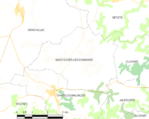
Saint-Dizier-les-Domaines
- commune in Creuse, France
- Country:
- Postal Code: 23270
- Coordinates: 46° 19' 8" N, 2° 2' 4" E
- GPS tracks (wikiloc): [Link]
- Area: 15.89 sq km
- Population: 185


Clugnat
- commune in Creuse, France
- Country:
- Postal Code: 23270
- Coordinates: 46° 18' 31" N, 2° 7' 5" E
- GPS tracks (wikiloc): [Link]
- Area: 42.42 sq km
- Population: 645


Nouzerines
- commune in Creuse, France
- Country:
- Postal Code: 23600
- Coordinates: 46° 23' 18" N, 2° 6' 31" E
- GPS tracks (wikiloc): [Link]
- Area: 19.09 sq km
- Population: 250