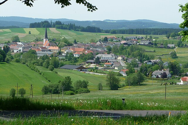
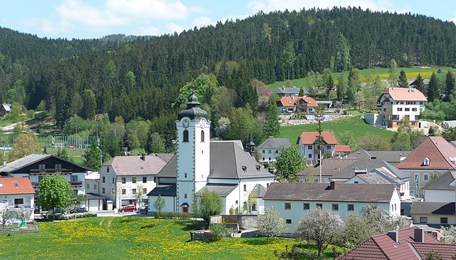
Bad Leonfelden (Bad Leonfelden)
- municipality in Austria
Bad Leonfelden, located in the Mühlviertel region of Austria, is surrounded by picturesque landscapes that make it a great destination for hiking enthusiasts. The area is known for its rolling hills, lush forests, and scenic viewpoints. Here are some aspects to consider for hiking in Bad Leonfelden:
Trails and Pathways
- Diverse Network of Trails: Bad Leonfelden offers a variety of trails suitable for different skill levels, from easy strolls to more challenging hikes.
- Panoramic Views: Many hikes offer beautiful views of the surrounding countryside and the Czech border, with opportunities to see local wildlife and flora.
- Signposted Routes: Most trails are well-marked, making it easier for hikers to navigate the area. Local hiking maps can provide essential information about distances and difficulty levels.
Popular Hiking Routes
- Kübelstein: A popular hiking destination near Bad Leonfelden that rewards hikers with spectacular views from the summit.
- Schwarze Berge: Offering a variety of trails through dense forests and scenic landscapes, it’s a great option for a day hike.
- Forest and Water Trails: Explore areas around the local rivers, enhancing the experience with water features and tranquility.
Best Time to Hike
- Seasonal Considerations: Spring and early fall often provide the best hiking conditions, with milder weather and beautiful natural scenery.
- Winter Hiking: Some trails may be accessible in winter for snowshoeing or winter hiking.
Tips for Hiking in Bad Leonfelden
- Preparation: Always check the weather conditions before heading out, as they can change rapidly in the mountains.
- Gear Up: Wear appropriate hiking footwear and bring along essentials like water, snacks, a first-aid kit, and navigation tools.
- Respect Nature: Follow Leave No Trace principles to preserve the natural beauty of the area.
Local Amenities
- Accommodations: Bad Leonfelden offers various accommodation options, including hotels and guesthouses, catering to outdoor enthusiasts.
- Local Culture: Take the opportunity to enjoy local cuisine and hospitality after a day of adventure, with numerous restaurants and cafes in the area.
Conclusion
Whether you're a beginner or an experienced hiker, Bad Leonfelden offers a rich hiking experience with its stunning natural beauty and varied trails. Always prioritize safety and respect for nature during your hikes to fully enjoy this charming region of Austria.
- Country:

- Postal Code: 4190
- Local Dialing Code: 07213
- Licence Plate Code: UU
- Coordinates: 48° 31' 31" N, 14° 17' 36" E


- GPS tracks (wikiloc): [Link]
- AboveSeaLevel: 750 м m
- Area: 40.33 sq km
- Population: 4180
- Web site: http://www.bad-leonfelden.ooe.gv.at/
- Wikipedia en: wiki(en)
- Wikipedia: wiki(de)
- Wikidata storage: Wikidata: Q663179
- Wikipedia Commons Category: [Link]
- Wikipedia Commons Maps Category: [Link]
- Freebase ID: [/m/03gvcr6]
- GeoNames ID: Alt: [7279898]
- VIAF ID: Alt: [249006814]
- GND ID: Alt: [4111261-1]
- TGN ID: [1025434]
- Austrian municipality key: [41603]
Shares border with regions:

Zwettl an der Rodl
- city in Upper Austria
Zwettl an der Rodl is a picturesque village located in Upper Austria, known for its beautiful landscapes and outdoor activities, making it a great spot for hiking enthusiasts. The region features a mix of hilly terrain, dense forests, and scenic views of the surrounding countryside....
- Country:

- Postal Code: 4180
- Local Dialing Code: 07212
- Licence Plate Code: UU
- Coordinates: 48° 28' 0" N, 14° 16' 2" E


- GPS tracks (wikiloc): [Link]
- AboveSeaLevel: 616 м m
- Area: 15.36 sq km
- Population: 1752
- Web site: [Link]

Schenkenfelden
- municipality in Austria
Schenkenfelden, located in Austria, offers a variety of hiking opportunities that cater to different levels of experience and fitness. Nestled in a picturesque landscape, the region is characterized by rolling hills, lush forests, and serene views of the surrounding countryside. Here are some key points to consider when hiking in Schenkenfelden:...
- Country:

- Postal Code: 4192
- Local Dialing Code: 07214
- Licence Plate Code: UU
- Coordinates: 48° 30' 1" N, 14° 21' 46" E


- GPS tracks (wikiloc): [Link]
- AboveSeaLevel: 734 м m
- Area: 25.65 sq km
- Population: 1569
- Web site: [Link]

Vorderweißenbach
- municipality in Austria
Vorderweißenbach is a picturesque area located in the Mühlviertel region of Austria, known for its beautiful landscapes, rolling hills, and dense forests. Here is an overview of what you can expect when hiking in and around Vorderweißenbach:...
- Country:

- Postal Code: 4191
- Local Dialing Code: 07219
- Licence Plate Code: UU
- Coordinates: 48° 33' 10" N, 14° 13' 12" E


- GPS tracks (wikiloc): [Link]
- AboveSeaLevel: 705 м m
- Area: 63.48 sq km
- Population: 2653
- Web site: [Link]

Reichenau im Mühlkreis
- municipality in Austria
 Hiking in Reichenau im Mühlkreis
Reichenau im Mühlkreis is a beautiful destination in Austria known for its stunning landscapes and hiking opportunities. Nestled in the Mühlviertel region, it offers a variety of trails that cater to different skill levels. Whether you’re a beginner or an experienced hiker, you will find trails that suit your preferences....
- Country:

- Postal Code: 4204
- Local Dialing Code: 07211
- Licence Plate Code: UU
- Coordinates: 48° 27' 23" N, 14° 21' 1" E


- GPS tracks (wikiloc): [Link]
- AboveSeaLevel: 667 м m
- Area: 9.54 sq km
- Population: 1329
- Web site: [Link]
Oberneukirchen
- municipality in Austria
Oberneukirchen, located in the picturesque region of Upper Austria, offers a variety of hiking opportunities amidst beautiful natural landscapes. The area is known for its charming countryside, rolling hills, and the scenic backdrop of the Alpine foothills. Here are some highlights to consider when hiking in and around Oberneukirchen:...
- Country:

- Postal Code: 4181
- Local Dialing Code: 07212
- Licence Plate Code: UU
- Coordinates: 48° 27' 53" N, 14° 13' 38" E


- GPS tracks (wikiloc): [Link]
- AboveSeaLevel: 774 м m
- Area: 34.55 sq km
- Population: 3202
- Web site: [Link]