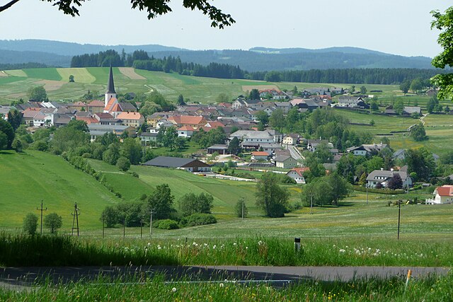
Urfahr-Umgebung District (Bezirk Urfahr-Umgebung)

- district of Austria
 Hiking in Urfahr-Umgebung District
Urfahr-Umgebung District, located in Upper Austria, offers a variety of hiking opportunities that cater to different skill levels and preferences. The district is characterized by picturesque landscapes, rolling hills, lush forests, and stunning viewpoints. Here are some highlights and tips for hiking in the area:
Trails and Routes
-
Donausteig Trail: This long-distance trail runs along the Danube River and passes through the Urfahr-Umgebung District. It features various segments that allow hikers to enjoy beautiful river views, charming villages, and local flora and fauna.
-
Mühlviertel Region: Known for its diverse hiking paths, Mühlviertel contains various marked trails, such as the "Mühlviertler Alm" route, which navigates through forests, meadows, and hills.
-
Local Hikes: Consider shorter local hikes, such as those around the Pöstlingberg, which offers not only hiking trails but also a panoramic view of Linz and the Danube River.
-
Nature Reserves: The area includes several nature reserves, where you can hike while observing local wildlife, particularly in the wetlands and riverbanks.
Tips for Hiking
-
Season Planning: The best time to hike in Urfahr-Umgebung is generally from late spring to early autumn (May to September) when the weather is pleasant. However, many trails can be hiked year-round, though winter conditions may require special gear.
-
Difficulty Levels: Ensure you choose a trail that matches your fitness and experience level. Some tracks are easier and family-friendly, while others may present challenging terrain.
-
Navigation: While many trails are well-marked, it's advisable to have a map or a GPS device and to familiarize yourself with the trail beforehand.
-
Safety: Always inform someone of your hiking plans and expected return time. Carry essentials such as water, snacks, a first-aid kit, and weather-appropriate clothing.
-
Respect Nature: Stay on marked paths to protect the delicate ecosystems. Follow local regulations regarding wildlife and resources.
Local Attractions
-
Cultural Spots: In addition to the natural beauty, the district has cultural attractions such as historical buildings, local festivals, and traditional Austrian cuisine to enjoy after your hike.
-
Public Transport: Many trailheads can be accessed via public transportation, making it easier to plan day hikes. Always check local schedules for buses and trains.
Urfahr-Umgebung District is a gem for hikers, offering unique experiences through its natural landscapes and cultural richness. Always prepare adequately and enjoy the beauty that this district has to offer!
- Country:

- Capital: Linz
- Licence Plate Code: UU
- Coordinates: 48° 24' 25" N, 14° 16' 41" E


- GPS tracks (wikiloc): [Link]
- Area: 660.23 sq km
- Web site: http://www.land-oberoesterreich.gv.at/cps/rde/xchg/SID-3DCFCFC3-2BF55AF9/ooe/hs.xsl/bh_urfahr_umgebung_DEU_HTML.htm
- Wikipedia en: wiki(en)
- Wikipedia: wiki(de)
- Wikidata storage: Wikidata: Q253585
- Wikipedia Commons Category: [Link]
- Freebase ID: [/m/0dy_lc]
- VIAF ID: Alt: [131375728]
- GND ID: Alt: [4062121-2]
- archINFORM location ID: [14681]
- Library of Congress authority ID: Alt: [n82133595]
Includes regions:

Zwettl an der Rodl
- city in Upper Austria
Hiking in Zwettl an der Rodl
Zwettl an der Rodl is a picturesque village located in Upper Austria, known for its beautiful landscapes and outdoor activities, making it a great spot for hiking enthusiasts. The region features a mix of hilly terrain, dense forests, and scenic views of the surrounding countryside....
- Country:
- Postal Code: 4180
- Local Dialing Code: 07212
- Licence Plate Code: UU
- Coordinates: 48° 28' 0" N, 14° 16' 2" E
- GPS tracks (wikiloc): [Link]
- AboveSeaLevel: 616 м m
- Area: 15.36 sq km
- Population: 1752
- Web site: [Link]

Feldkirchen an der Donau
- municipality in Austria
Hiking in Feldkirchen an der Donau
Feldkirchen an der Donau, located in Austria, is a charming area with scenic landscapes perfect for hiking enthusiasts. The region is characterized by its picturesque countryside, rolling hills, and proximity to the Danube River, offering opportunities for various outdoor adventures....
- Country:
- Postal Code: 4101
- Local Dialing Code: 07233
- Licence Plate Code: UU
- Coordinates: 48° 20' 44" N, 14° 3' 1" E
- GPS tracks (wikiloc): [Link]
- AboveSeaLevel: 268 м m
- Area: 39.35 sq km
- Population: 5361
- Web site: [Link]

Altenberg bei Linz
- municipality in Austria
Hiking in Altenberg bei Linz
Altenberg bei Linz, located in Austria, offers a beautiful backdrop for hiking enthusiasts. Nestled in the Upper Austria region, this area is characterized by its lush forests, rolling hills, and scenic landscapes, making it a fantastic destination for outdoor activities....
- Country:
- Postal Code: 4203
- Local Dialing Code: 07230
- Licence Plate Code: UU
- Coordinates: 48° 22' 23" N, 14° 21' 1" E
- GPS tracks (wikiloc): [Link]
- AboveSeaLevel: 592 м m
- Area: 36.2 sq km
- Population: 4553
- Web site: [Link]

Engerwitzdorf
- municipality in Austria
Hiking in Engerwitzdorf
Engerwitzdorf, located in Austria, offers a variety of scenic hiking opportunities for both casual walkers and more experienced hikers. The region is characterized by its picturesque landscapes, lush forests, and rolling hills, making it an ideal destination for nature lovers....
- Country:
- Postal Code: 4209
- Local Dialing Code: 0 72 35
- Licence Plate Code: UU
- Coordinates: 48° 20' 23" N, 14° 25' 32" E
- GPS tracks (wikiloc): [Link]
- AboveSeaLevel: 333 м m
- Area: 41.09 sq km
- Population: 8790
- Web site: [Link]
Schenkenfelden
- municipality in Austria
Hiking in Schenkenfelden
Schenkenfelden, located in Austria, offers a variety of hiking opportunities that cater to different levels of experience and fitness. Nestled in a picturesque landscape, the region is characterized by rolling hills, lush forests, and serene views of the surrounding countryside. Here are some key points to consider when hiking in Schenkenfelden:...
- Country:
- Postal Code: 4192
- Local Dialing Code: 07214
- Licence Plate Code: UU
- Coordinates: 48° 30' 1" N, 14° 21' 46" E
- GPS tracks (wikiloc): [Link]
- AboveSeaLevel: 734 м m
- Area: 25.65 sq km
- Population: 1569
- Web site: [Link]

Kirchschlag bei Linz
- municipality in Austria
Hiking in Kirchschlag bei Linz
Kirchschlag bei Linz, located in Austria's Upper Austria region, offers a range of hiking opportunities that cater to various skill levels. The area is characterized by its picturesque landscapes, rolling hills, and rich natural scenery, making it a great destination for outdoor enthusiasts....
- Country:
- Postal Code: 4202
- Local Dialing Code: 07215
- Licence Plate Code: UU
- Coordinates: 48° 24' 49" N, 14° 16' 41" E
- GPS tracks (wikiloc): [Link]
- AboveSeaLevel: 896 м m
- Area: 16.78 sq km
- Population: 2138
- Web site: [Link]


Steyregg
- municipality in Austria
Hiking in Steyregg
Steyregg is a charming municipality located in Upper Austria, near the city of Linz. It possesses a variety of beautiful landscapes and hiking trails suitable for different skill levels, making it an excellent destination for outdoor enthusiasts....
- Country:
- Postal Code: 4221
- Local Dialing Code: 0732
- Licence Plate Code: UU
- Coordinates: 48° 17' 1" N, 14° 22' 0" E
- GPS tracks (wikiloc): [Link]
- AboveSeaLevel: 259 м m
- Area: 33.07 sq km
- Population: 4889
- Web site: [Link]

Bad Leonfelden
- municipality in Austria
Hiking in Bad Leonfelden
Bad Leonfelden, located in the Mühlviertel region of Austria, is surrounded by picturesque landscapes that make it a great destination for hiking enthusiasts. The area is known for its rolling hills, lush forests, and scenic viewpoints. Here are some aspects to consider for hiking in Bad Leonfelden:...
- Country:
- Postal Code: 4190
- Local Dialing Code: 07213
- Licence Plate Code: UU
- Coordinates: 48° 31' 31" N, 14° 17' 36" E
- GPS tracks (wikiloc): [Link]
- AboveSeaLevel: 750 м m
- Area: 40.33 sq km
- Population: 4180
- Web site: [Link]

Eidenberg
- municipality in Austria
Hiking in Eidenberg
Eidenberg, located in Austria, is a picturesque region offering various opportunities for hiking enthusiasts. The area is characterized by its beautiful landscapes, including rolling hills, lush forests, and stunning views of the surrounding nature....
- Country:
- Postal Code: 4201
- Licence Plate Code: UU
- Coordinates: 48° 23' 42" N, 14° 13' 51" E
- GPS tracks (wikiloc): [Link]
- AboveSeaLevel: 685 м m
- Area: 29 sq km
- Population: 2105
- Web site: [Link]


Gallneukirchen
- municipality in Austria
Hiking in Gallneukirchen
Gallneukirchen is located in Austria, near the beautiful natural landscapes of the Mühlviertel region of Upper Austria. This area offers a variety of hiking opportunities, with trails that cater to different skill levels and preferences. Here are some highlights for hiking in and around Gallneukirchen:...
- Country:
- Postal Code: 4210
- Local Dialing Code: 07235
- Licence Plate Code: UU
- Coordinates: 48° 21' 11" N, 14° 24' 57" E
- GPS tracks (wikiloc): [Link]
- AboveSeaLevel: 336 м m
- Area: 5.18 sq km
- Population: 6492
- Web site: [Link]
Vorderweißenbach
- municipality in Austria
Hiking in Vorderweißenbach
Vorderweißenbach is a picturesque area located in the Mühlviertel region of Austria, known for its beautiful landscapes, rolling hills, and dense forests. Here is an overview of what you can expect when hiking in and around Vorderweißenbach:...
- Country:
- Postal Code: 4191
- Local Dialing Code: 07219
- Licence Plate Code: UU
- Coordinates: 48° 33' 10" N, 14° 13' 12" E
- GPS tracks (wikiloc): [Link]
- AboveSeaLevel: 705 м m
- Area: 63.48 sq km
- Population: 2653
- Web site: [Link]
Sonnberg im Mühlkreis
- municipality in Austria
Hiking in Sonnberg im Mühlkreis
Sonnberg im Mühlkreis is a picturesque area in Austria, located in the Upper Austria region. It's known for its beautiful landscapes, rolling hills, and peaceful surroundings, making it a delightful destination for hikers....
- Country:
- Postal Code: 4180
- Local Dialing Code: 07212
- Licence Plate Code: UU
- Coordinates: 48° 27' 34" N, 14° 17' 27" E
- GPS tracks (wikiloc): [Link]
- AboveSeaLevel: 740 м m
- Area: 12.55 sq km
- Population: 966
- Web site: [Link]

Sankt Gotthard im Mühlkreis
- municipality in Austria
Hiking in Sankt Gotthard im Mühlkreis
Sankt Gotthard im Mühlkreis is a picturesque village located in Upper Austria, surrounded by beautiful landscapes that are perfect for hiking. The area boasts various trails that cater to different skill levels, making it suitable for both beginners and experienced hikers....
- Country:
- Postal Code: 4112
- Local Dialing Code: 07234
- Licence Plate Code: UU
- Coordinates: 48° 22' 10" N, 14° 7' 2" E
- GPS tracks (wikiloc): [Link]
- AboveSeaLevel: 473 м m
- Area: 11.99 sq km
- Population: 1332
- Web site: [Link]

Walding
- municipality in Austria
Hiking in Walding
Walding, a charming municipality in Austria, offers a variety of hiking opportunities for outdoor enthusiasts. Nestled in the picturesque landscape of Upper Austria, Walding is known for its beautiful scenery, rolling hills, and lush greenery....
- Country:
- Postal Code: 4111
- Local Dialing Code: 07234
- Licence Plate Code: UU
- Coordinates: 48° 21' 1" N, 14° 9' 44" E
- GPS tracks (wikiloc): [Link]
- AboveSeaLevel: 303 м m
- Area: 15.32 sq km
- Population: 4095
- Web site: [Link]


Reichenthal
- municipality in Austria
Hiking in Reichenthal
Reichenthal is a charming village located in Austria, surrounded by picturesque landscapes that make it an excellent destination for hiking enthusiasts. The area features a variety of trails that cater to different skill levels, from leisurely walks to more challenging hikes....
- Country:
- Postal Code: 4193
- Local Dialing Code: 07214
- Licence Plate Code: UU
- Coordinates: 48° 32' 47" N, 14° 23' 1" E
- GPS tracks (wikiloc): [Link]
- AboveSeaLevel: 683 м m
- Area: 18.85 sq km
- Population: 1513
- Web site: [Link]
Ottenschlag im Mühlkreis
- municipality in Austria
Hiking in Ottenschlag im Mühlkreis
Ottenschlag im Mühlkreis, located in Upper Austria, is a picturesque region known for its beautiful landscapes and outdoor activities, including hiking. The area is characterized by rolling hills, dense forests, and stunning views of the surrounding countryside. Here are a few highlights and tips for hiking in Ottenschlag im Mühlkreis:...
- Country:
- Postal Code: 4204
- Local Dialing Code: 07211
- Licence Plate Code: UU
- Coordinates: 48° 28' 0" N, 14° 23' 1" E
- GPS tracks (wikiloc): [Link]
- AboveSeaLevel: 806 м m
- Area: 13.18 sq km
- Population: 539
- Web site: [Link]


Gramastetten
- municipality in Austria
Hiking in Gramastetten
Gramastetten is a charming town located in Austria, near the city of Linz. The region is known for its scenic landscapes, rolling hills, and lush forests, making it a great destination for hiking enthusiasts....
- Country:
- Local Dialing Code: 0 72 39
- Licence Plate Code: UU
- Coordinates: 48° 22' 52" N, 14° 11' 24" E
- GPS tracks (wikiloc): [Link]
- AboveSeaLevel: 545 м m
- Area: 40.2 sq km
- Population: 5102
- Web site: [Link]
Herzogsdorf
- municipality in Austria
Hiking in Herzogsdorf
Herzogsdorf, located in Austria, is known for its picturesque landscapes and charming rural atmosphere. While it may not be as heavily trafficked as some larger hiking destinations, it offers a variety of trails that cater to different skill levels, making it a great spot for hiking enthusiasts....
- Country:
- Postal Code: 4175
- Local Dialing Code: 07231
- Licence Plate Code: UU
- Coordinates: 48° 25' 52" N, 14° 6' 49" E
- GPS tracks (wikiloc): [Link]
- AboveSeaLevel: 591 м m
- Area: 35.39 sq km
- Population: 2506
- Web site: [Link]
Haibach im Mühlkreis
- municipality in Austria
Hiking in Haibach im Mühlkreis
Haibach im Mühlkreis is a beautiful area in Austria, located in the Mühlviertel region of Upper Austria. It is known for its picturesque landscapes, rolling hills, and tranquil forests, making it a great destination for hiking enthusiasts of all levels....
- Country:
- Postal Code: 4204
- Local Dialing Code: 07211
- Licence Plate Code: UU
- Coordinates: 48° 26' 41" N, 14° 21' 32" E
- GPS tracks (wikiloc): [Link]
- AboveSeaLevel: 780 м m
- Area: 14.48 sq km
- Population: 904
- Web site: [Link]

Reichenau im Mühlkreis
- municipality in Austria
Hiking in Reichenau im Mühlkreis
Reichenau im Mühlkreis is a beautiful destination in Austria known for its stunning landscapes and hiking opportunities. Nestled in the Mühlviertel region, it offers a variety of trails that cater to different skill levels. Whether you’re a beginner or an experienced hiker, you will find trails that suit your preferences....
- Country:
- Postal Code: 4204
- Local Dialing Code: 07211
- Licence Plate Code: UU
- Coordinates: 48° 27' 23" N, 14° 21' 1" E
- GPS tracks (wikiloc): [Link]
- AboveSeaLevel: 667 м m
- Area: 9.54 sq km
- Population: 1329
- Web site: [Link]
Lichtenberg
- municipality in Upper Austria, Austria
Hiking in Lichtenberg
Lichtenberg, situated in Austria, offers a beautiful backdrop for hiking enthusiasts with its picturesque landscapes, diverse trails, and charming rural settings. Here are some highlights and considerations for hiking in the area:...
- Country:
- Postal Code: 4040
- Local Dialing Code: 07239
- Licence Plate Code: UU
- Coordinates: 48° 21' 36" N, 14° 15' 29" E
- GPS tracks (wikiloc): [Link]
- AboveSeaLevel: 620 м m
- Area: 18.49 sq km
- Population: 2637
- Web site: [Link]
Oberneukirchen
- municipality in Austria
Hiking in Oberneukirchen
Oberneukirchen, located in the picturesque region of Upper Austria, offers a variety of hiking opportunities amidst beautiful natural landscapes. The area is known for its charming countryside, rolling hills, and the scenic backdrop of the Alpine foothills. Here are some highlights to consider when hiking in and around Oberneukirchen:...
- Country:
- Postal Code: 4181
- Local Dialing Code: 07212
- Licence Plate Code: UU
- Coordinates: 48° 27' 53" N, 14° 13' 38" E
- GPS tracks (wikiloc): [Link]
- AboveSeaLevel: 774 м m
- Area: 34.55 sq km
- Population: 3202
- Web site: [Link]


Alberndorf in der Riedmark
- municipality in Austria
Hiking in Alberndorf in der Riedmark
Alberndorf in der Riedmark is a picturesque municipality located in the Mauthausen district of Austria, nestled in a beautiful region characterized by rolling hills, lush forests, and charming rural landscapes. While it's not particularly known as a major hiking destination, it offers a variety of local trails suitable for hiking enthusiasts looking for scenic walks and outdoor experiences....
- Country:
- Postal Code: 4211
- Local Dialing Code: 07235
- Licence Plate Code: UU
- Coordinates: 48° 24' 24" N, 14° 25' 1" E
- GPS tracks (wikiloc): [Link]
- AboveSeaLevel: 570 м m
- Area: 41 sq km
- Population: 4083
- Web site: [Link]

Ottensheim
- municipality in Austria
Hiking in Ottensheim
Ottensheim is a charming town located in Upper Austria, situated on the banks of the Danube River, just a short distance from Linz. The region around Ottensheim offers a variety of hiking opportunities for both novice and experienced hikers, with scenic views, lush landscapes, and a mix of terrain....
- Country:
- Postal Code: 4100
- Local Dialing Code: 07234
- Licence Plate Code: UU
- Coordinates: 48° 20' 0" N, 14° 10' 37" E
- GPS tracks (wikiloc): [Link]
- AboveSeaLevel: 270 м m
- Area: 11.81 sq km
- Population: 4721
- Web site: [Link]
Goldwörth
- municipality in Austria
Hiking in Goldwörth
Goldwörth, a charming municipality in Austria's Upper Austria region, offers a range of scenic hiking opportunities for both beginners and experienced hikers. The surrounding landscape is characterized by rolling hills, lush forests, and picturesque countryside, making it an appealing destination for outdoor enthusiasts....
- Country:
- Postal Code: 4102
- Local Dialing Code: 0 72 34
- Licence Plate Code: UU
- Coordinates: 48° 20' 39" N, 14° 6' 0" E
- GPS tracks (wikiloc): [Link]
- AboveSeaLevel: 262 м m
- Area: 11 sq km
- Population: 840
- Web site: [Link]

Hellmonsödt
- municipality in Austria
Hiking in Hellmonsödt
Hellmonsödt is a picturesque area in Austria, known for its beautiful landscapes, lush forests, and scenic trails. Located near Linz in the state of Upper Austria, it offers a variety of hiking options suitable for all skill levels. Here are some highlights and tips for hiking in Hellmonsödt:...
- Country:
- Postal Code: 4202
- Local Dialing Code: 07215
- Licence Plate Code: UU
- Coordinates: 48° 25' 57" N, 14° 18' 1" E
- GPS tracks (wikiloc): [Link]
- AboveSeaLevel: 825 м m
- Area: 18.08 sq km
- Population: 2303
- Web site: [Link]

Puchenau
- municipality in Austria
Hiking in Puchenau
Puchenau, located in Austria near the city of Linz, offers a charming environment for hiking enthusiasts. The region is characterized by beautiful landscapes, rolling hills, and scenic views, especially along the banks of the Danube River....
- Country:
- Licence Plate Code: UU
- Coordinates: 48° 18' 39" N, 14° 14' 29" E
- GPS tracks (wikiloc): [Link]
- AboveSeaLevel: 265 м m
- Area: 8.19 sq km
- Population: 4445
- Web site: [Link]