Bagnères-de-Luchon (Bagnères-de-Luchon)

- commune in Haute-Garonne, France
- Country:

- Postal Code: 31110
- Coordinates: 42° 47' 26" N, 0° 35' 38" E


- GPS tracks (wikiloc): [Link]
- Area: 52.8 sq km
- Population: 2384
- Web site: http://www.mairie-luchon.fr
- Wikipedia en: wiki(en)
- Wikipedia: wiki(fr)
- Wikidata storage: Wikidata: Q238393
- Wikipedia Commons Gallery: [Link]
- Wikipedia Commons Category: [Link]
- Freebase ID: [/m/07v2h9]
- Freebase ID: [/m/07v2h9]
- GeoNames ID: Alt: [6448265]
- GeoNames ID: Alt: [6448265]
- SIREN number: [213100423]
- SIREN number: [213100423]
- BnF ID: [152550384]
- BnF ID: [152550384]
- VIAF ID: Alt: [160862230]
- VIAF ID: Alt: [160862230]
- OSM relation ID: [106255]
- OSM relation ID: [106255]
- GND ID: Alt: [4348004-4]
- GND ID: Alt: [4348004-4]
- Library of Congress authority ID: Alt: [n91016492]
- Library of Congress authority ID: Alt: [n91016492]
- PACTOLS thesaurus ID: [pcrtsVVmASqdFq]
- PACTOLS thesaurus ID: [pcrtsVVmASqdFq]
- MusicBrainz area ID: [8a627aeb-0ca5-4960-a227-171c58d0a81b]
- MusicBrainz area ID: [8a627aeb-0ca5-4960-a227-171c58d0a81b]
- Gran Enciclopèdia Catalana ID: [0038665]
- Gran Enciclopèdia Catalana ID: [0038665]
- INSEE municipality code: 31042
- INSEE municipality code: 31042
Shares border with regions:

Saint-Mamet
- commune in Haute-Garonne, France
- Country:
- Postal Code: 31110
- Coordinates: 42° 46' 53" N, 0° 36' 11" E
- GPS tracks (wikiloc): [Link]
- Area: 11.16 sq km
- Population: 552
- Web site: [Link]

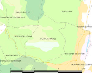
Cazarilh-Laspènes
- commune in Haute-Garonne, France
- Country:
- Postal Code: 31110
- Coordinates: 42° 47' 57" N, 0° 34' 39" E
- GPS tracks (wikiloc): [Link]
- Area: 2.37 sq km
- Population: 27

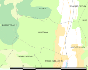
Moustajon
- commune in Haute-Garonne, France
- Country:
- Postal Code: 31110
- Coordinates: 42° 48' 52" N, 0° 35' 51" E
- GPS tracks (wikiloc): [Link]
- Area: 2.3 sq km
- Population: 152


Montauban-de-Luchon
- commune in Haute-Garonne, France
- Country:
- Postal Code: 31110
- Coordinates: 42° 47' 33" N, 0° 36' 35" E
- GPS tracks (wikiloc): [Link]
- Area: 6.02 sq km
- Population: 479
- Web site: [Link]


Juzet-de-Luchon
- commune in Haute-Garonne, France
- Country:
- Postal Code: 31110
- Coordinates: 42° 48' 31" N, 0° 36' 32" E
- GPS tracks (wikiloc): [Link]
- Area: 6.8 sq km
- Population: 367
- Web site: [Link]

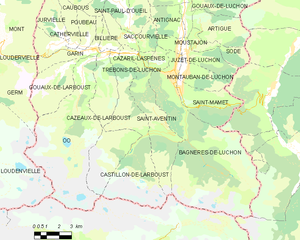
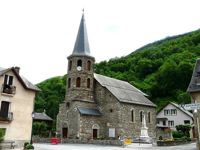
Saint-Aventin
- commune in Haute-Garonne, France
- Country:
- Postal Code: 31110
- Coordinates: 42° 48' 23" N, 0° 32' 46" E
- GPS tracks (wikiloc): [Link]
- Area: 17.4 sq km
- Population: 105