Bagnara Calabra (Bagnara Calabra)
.svg)
- Italian comune
 Hiking in Bagnara Calabra
Bagnara Calabra, located on the Tyrrhenian coast of Calabria, Italy, offers a unique blend of coastal and mountainous hiking opportunities. Here are some of the highlights for hiking in this beautiful area:
Scenic Trails
-
Coastal Trails: You can find stunning trails that follow the coastline, providing breathtaking views of the sea and the surrounding landscapes. The trails often take you through Mediterranean vegetation, including olive groves and fragrant herbs.
-
Aspromonte National Park: Just inland from Bagnara Calabra, this national park features a variety of hiking routes that cater to different skill levels. You can explore deep gorges, rugged mountains, and pristine waterfalls. The trails here can range from easy walks to challenging hikes.
-
Viewpoints: Many trails lead to panoramic viewpoints overlooking the coast and the mountainous terrain. Don’t miss spots that provide stunning views of the Strait of Messina and, on clear days, even Mount Etna.
Natural Attractions
- Waterfalls: Some trails in the surrounding areas of the Aspromonte include beautiful waterfalls that are perfect for a refreshing break during your hike.
- Flora and Fauna: The region boasts rich biodiversity, so keep an eye out for unique plant species and possibly spot wildlife such as deer, foxes, and various birds.
Historical Sites
Many trails may lead you to historical ruins, ancient churches, or mountain villages that offer insight into the local culture and history. Walking through these sites adds to the overall experience.
Tips for Hiking in Bagnara Calabra
- Weather: Be mindful of the weather conditions, as they can change rapidly in the mountains. The best time for hiking is typically spring and fall.
- Gear: Ensure you have appropriate hiking gear, including sturdy footwear, water, snacks, and a map or GPS device, as trails can sometimes be unmarked.
- Local Guidance: Consider hiring a local guide for a more enriching experience. They can share insights into the area's natural and cultural history.
- Respect Nature: Follow the Leave No Trace principles to protect the beautiful environment.
Preparing for Your Hike
- Know Your Limits: Choose trails that match your fitness level.
- Stay Hydrated and Fueled: Bring plenty of water and snacks to keep your energy levels up.
- Plan Your Route: Have a sense of where you’re headed and the estimated time it will take.
Hiking in Bagnara Calabra can be a rewarding experience, offering a mix of natural beauty, cultural heritage, and adventure. Enjoy your trek!
- Country:

- Postal Code: 89011
- Local Dialing Code: 0966
- Licence Plate Code: RC
- Coordinates: 38° 17' 0" N, 15° 49' 0" E


- GPS tracks (wikiloc): [Link]
- AboveSeaLevel: 50 м m
- Area: 24.85 sq km
- Population: 10120
- Web site: http://www.comunebagnara.it/
- Wikipedia en: wiki(en)
- Wikipedia: wiki(it)
- Wikidata storage: Wikidata: Q54565
- Wikipedia Commons Category: [Link]
- Freebase ID: [/m/0gnxpm]
- GeoNames ID: Alt: [6539094]
- VIAF ID: Alt: [152491118]
- OSM relation ID: [39598]
- GND ID: Alt: [4428382-9]
- archINFORM location ID: [920]
- Library of Congress authority ID: Alt: [n84044956]
- MusicBrainz area ID: [84424321-c799-4807-86c8-074f1e9dc18c]
- UN/LOCODE: [ITBCB]
- ISTAT ID: 080007
- Italian cadastre code: A552
Shares border with regions:


Melicuccà
- Italian comune
Hiking in Melicuccà
Melicuccà is a small village located in the Calabria region of southern Italy, nestled within the Aspromonte National Park. While it may not be as widely known as some other hiking destinations, it offers a range of hiking opportunities suited for various skill levels. Here are some aspects to consider when hiking in and around Melicuccà:...
- Country:
- Postal Code: 89020
- Local Dialing Code: 0966
- Licence Plate Code: RC
- Coordinates: 38° 18' 11" N, 15° 52' 54" E
- GPS tracks (wikiloc): [Link]
- AboveSeaLevel: 273 м m
- Area: 17.4 sq km
- Population: 895
- Web site: [Link]
Sant'Eufemia d'Aspromonte
- Italian comune
Hiking in Sant'Eufemia d'Aspromonte
Sant'Eufemia d'Aspromonte is a beautiful village located in the Aspromonte National Park in southern Italy, specifically in Calabria. The area is known for its stunning landscapes, rugged terrain, and diverse flora and fauna, making it an excellent destination for hiking enthusiasts....
- Country:
- Postal Code: 89027
- Local Dialing Code: 0966
- Licence Plate Code: RC
- Coordinates: 38° 16' 0" N, 15° 52' 0" E
- GPS tracks (wikiloc): [Link]
- AboveSeaLevel: 420 м m
- Area: 32.88 sq km
- Population: 4079
- Web site: [Link]
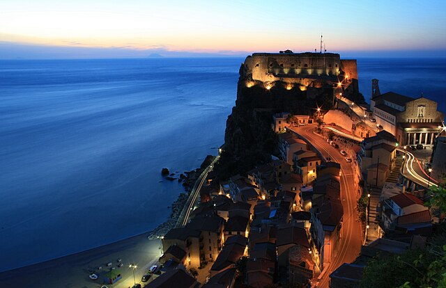

Scilla
- Italian comune
Hiking in Scilla
Scilla, a picturesque coastal village in Calabria, Italy, offers stunning landscapes and a unique blend of mountain and sea hiking experiences. Nestled along the Tyrrhenian coast, Scilla is known for its crystal-clear waters, sandy beaches, and dramatic cliffs, providing a beautiful backdrop for hikers....
- Country:
- Postal Code: 89058
- Local Dialing Code: 0965
- Licence Plate Code: RC
- Coordinates: 38° 15' 0" N, 15° 43' 0" E
- GPS tracks (wikiloc): [Link]
- AboveSeaLevel: 91 м m
- Area: 44.13 sq km
- Population: 4885
- Web site: [Link]


Seminara
- Italian comune
Hiking in Seminara
Seminara is a small town located in Calabria, Italy, known for its beautiful landscapes, rich history, and proximity to both the mountains and the Mediterranean coast. Hiking in and around Seminara offers a range of experiences, from scenic coastal trails to mountain paths that provide breathtaking views....
- Country:
- Postal Code: 89028
- Local Dialing Code: 0966
- Licence Plate Code: RC
- Coordinates: 38° 20' 0" N, 15° 52' 0" E
- GPS tracks (wikiloc): [Link]
- AboveSeaLevel: 290 м m
- Area: 33.85 sq km
- Population: 2714
- Web site: [Link]