Bagnolo Piemonte (Bagnolo Piemonte)
- Italian comune
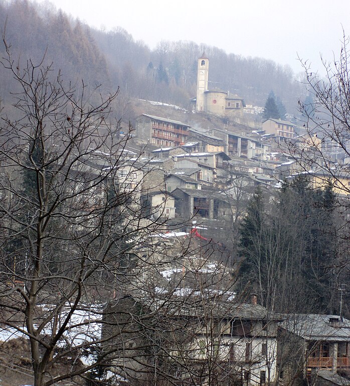
 Hiking in Bagnolo Piemonte
Bagnolo Piemonte is a picturesque village located in the Province of Cuneo in the Piedmont region of northern Italy. Nestled in the foothills of the Alps, it offers a range of beautiful hiking opportunities suitable for various skill levels.
Hiking Trails and Areas
-
Monte Bracco: This mountain offers several trails with varying difficulties. The views from the summit are stunning, with a panoramic look at the surrounding valleys and peaks.
-
Valle del Cervo: A beautiful valley that is perfect for those looking to hike through lush landscapes. The trails here often lead to charming waterfalls and natural attractions.
-
Cascina Savoia: For a more relaxed hike, you can explore the trails around this historic site. It's an excellent option for families and offers a chance to learn about the local culture.
-
Sentiero dei Gualtieri: This trail offers an immersive experience in nature, with marked paths leading through dense forests and across small streams.
Tips for Hiking in Bagnolo Piemonte
- Seasonal Considerations: Spring and early autumn are typically the best times for hiking, as the weather is pleasant, and the scenery is vibrant.
- Equipment: Wear sturdy hiking shoes, bring enough water, and pack snacks. It’s also helpful to have a map or a GPS device, as some trails may not be clearly marked.
- Local Guidance: Consider hiring a local guide or joining a hiking group to get the most out of your experience and to learn about the area's flora and fauna.
- Respect Nature: Follow Leave No Trace principles. Stay on marked trails and be mindful of your impact on the environment.
- Weather Awareness: The weather can change quickly in the mountains, so check conditions beforehand and be prepared for sudden changes during your hike.
In addition to hiking, Bagnolo Piemonte is an excellent place to enjoy local cuisine and hospitality. Be sure to take the time to explore the village, interact with locals, and experience the culture of the Piedmont region.
- Country:

- Postal Code: 12031
- Local Dialing Code: 0175
- Licence Plate Code: CN
- Coordinates: 44° 46' 0" N, 7° 19' 0" E


- GPS tracks (wikiloc): [Link]
- Area: 63.25 sq km
- Population: 5969
- Web site: http://www.comune.bagnolo.cn.it/
- Wikipedia en: wiki(en)
- Wikipedia: wiki(it)
- Wikidata storage: Wikidata: Q18351
- Wikipedia Commons Category: [Link]
- Freebase ID: [/m/0gb7hq]
- GeoNames ID: Alt: [6541451]
- VIAF ID: Alt: [145870934]
- OSM relation ID: [43550]
- archINFORM location ID: [1023]
- UN/LOCODE: [ITBOP]
- ISTAT ID: 004009
- Italian cadastre code: A571
Shares border with regions:


Rorà
- Italian comune
Hiking in Rorà
Rorà is a small village located in the Piedmont region of Italy, surrounded by beautiful natural landscapes that are ideal for hiking. Here’s what you can expect when hiking in this area:...
- Country:
- Postal Code: 10060
- Local Dialing Code: 0121
- Licence Plate Code: TO
- Coordinates: 44° 48' 0" N, 7° 12' 0" E
- GPS tracks (wikiloc): [Link]
- AboveSeaLevel: 967 м m
- Area: 12.41 sq km
- Population: 244
- Web site: [Link]


Villar Pellice
- Italian comune
Hiking in Villar Pellice
Villar Pellice is a stunning location nestled in the Pellice Valley in the Piedmont region of Italy. Known for its breathtaking natural beauty, the area offers a range of hiking opportunities that cater to different levels of experience, from leisurely walks to more challenging trails....
- Country:
- Postal Code: 10060
- Local Dialing Code: 0121
- Licence Plate Code: TO
- Coordinates: 44° 48' 0" N, 7° 10' 0" E
- GPS tracks (wikiloc): [Link]
- Area: 60.29 sq km
- Population: 1082
- Web site: [Link]

Barge
- Italian comune
Hiking in Barge
Barge is a small town located in the Piedmont region of Italy, surrounded by beautiful natural landscapes, making it a great destination for hiking enthusiasts. Here’s what you can expect when hiking in and around Barge:...
- Country:
- Postal Code: 12032
- Local Dialing Code: 0175
- Licence Plate Code: CN
- Coordinates: 44° 44' 0" N, 7° 19' 0" E
- GPS tracks (wikiloc): [Link]
- AboveSeaLevel: 316 м m
- Area: 81.99 sq km
- Population: 7699
- Web site: [Link]

Crissolo
- Italian comune
Hiking in Crissolo
Crissolo is a charming mountain village situated in the Susa Valley in the Piedmont region of Italy. It's a fantastic destination for hiking enthusiasts, offering a variety of trails that cater to different experience levels and preferences. Here are some key points to consider when hiking in Crissolo:...
- Country:
- Postal Code: 12030
- Local Dialing Code: 0175
- Licence Plate Code: CN
- Coordinates: 44° 42' 0" N, 7° 10' 0" E
- GPS tracks (wikiloc): [Link]
- AboveSeaLevel: 1318 м m
- Area: 52.05 sq km
- Population: 162
- Web site: [Link]
Ostana
- Italian comune
Hiking in Ostana
Ostana is a picturesque village located in the Piedmont region of Italy, nestled in the Susa Valley of the Cottian Alps. It's known for its stunning natural landscapes, rich cultural heritage, and a range of hiking opportunities. Here’s what you need to know about hiking in Ostana:...
- Country:
- Postal Code: 12030
- Local Dialing Code: 0175
- Licence Plate Code: CN
- Coordinates: 44° 42' 0" N, 7° 11' 0" E
- GPS tracks (wikiloc): [Link]
- AboveSeaLevel: 1250 м m
- Area: 14.09 sq km
- Population: 81
- Web site: [Link]
Bibiana
- Italian comune
Hiking in Bibiana
Bibiana, located in the Piedmont region of Italy, is a charming destination for hiking enthusiasts. Nestled in the Susa Valley, it offers stunning landscapes characterized by rolling hills, wooded areas, and panoramic views of the surrounding mountains, including the Alps....
- Country:
- Postal Code: 10060
- Local Dialing Code: 0121
- Licence Plate Code: TO
- Coordinates: 44° 48' 0" N, 7° 17' 0" E
- GPS tracks (wikiloc): [Link]
- AboveSeaLevel: 320 м m
- Area: 18.6 sq km
- Population: 3463
- Web site: [Link]

Cavour
- Italian comune
Hiking in Cavour
Cavour, located in the Piedmont region of Italy, is a charming town that offers a variety of hiking opportunities for outdoor enthusiasts. Surrounded by beautiful landscapes, including rolling hills, forests, and scenic views of the Alps, Cavour serves as a great base for a range of hiking experiences. Here are some highlights related to hiking in and around Cavour:...
- Country:
- Postal Code: 10061
- Local Dialing Code: 0121
- Licence Plate Code: TO
- Coordinates: 44° 47' 0" N, 7° 23' 0" E
- GPS tracks (wikiloc): [Link]
- AboveSeaLevel: 300 м m
- Area: 48.96 sq km
- Population: 5492
- Web site: [Link]


Luserna San Giovanni
- Italian municipality
Hiking in Luserna San Giovanni
Luserna San Giovanni, located in the Piedmont region of Italy, is a fantastic destination for hiking enthusiasts. Nestled in the Susa Valley and surrounded by the picturesque foothills of the Alps, it offers a variety of trails that cater to hikers of different skill levels....
- Country:
- Postal Code: 10062
- Local Dialing Code: 0121
- Licence Plate Code: TO
- Coordinates: 44° 49' 0" N, 7° 15' 0" E
- GPS tracks (wikiloc): [Link]
- AboveSeaLevel: 475 м m
- Area: 17.74 sq km
- Population: 7297
- Web site: [Link]