Bailly-Romainvilliers (Bailly-Romainvilliers)

- commune in Seine-et-Marne, France
- Country:

- Postal Code: 77700
- Coordinates: 48° 50' 49" N, 2° 49' 23" E


- GPS tracks (wikiloc): [Link]
- Area: 8.01 sq km
- Population: 7500
- Web site: http://www.bailly-romainvilliers.fr
- Wikipedia en: wiki(en)
- Wikipedia: wiki(fr)
- Wikidata storage: Wikidata: Q250620
- Wikipedia Commons Category: [Link]
- Freebase ID: [/m/02pkp5j]
- Freebase ID: [/m/02pkp5j]
- GeoNames ID: Alt: [6451137]
- GeoNames ID: Alt: [6451137]
- SIREN number: [217700186]
- SIREN number: [217700186]
- BnF ID: [15275359b]
- BnF ID: [15275359b]
- PACTOLS thesaurus ID: [pcrt3D19tyZkMy]
- PACTOLS thesaurus ID: [pcrt3D19tyZkMy]
- INSEE municipality code: 77018
- INSEE municipality code: 77018
Shares border with regions:

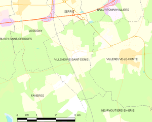
Villeneuve-Saint-Denis
- commune in Seine-et-Marne, France
- Country:
- Postal Code: 77174
- Coordinates: 48° 48' 56" N, 2° 47' 35" E
- GPS tracks (wikiloc): [Link]
- Area: 7.4 sq km
- Population: 861


Villeneuve-le-Comte
- commune in Seine-et-Marne, France
- Country:
- Postal Code: 77174
- Coordinates: 48° 48' 49" N, 2° 49' 43" E
- GPS tracks (wikiloc): [Link]
- Area: 19.09 sq km
- Population: 1852


Coutevroult
- commune in Seine-et-Marne, France
- Country:
- Postal Code: 77580
- Coordinates: 48° 51' 45" N, 2° 51' 8" E
- GPS tracks (wikiloc): [Link]
- Area: 7.79 sq km
- Population: 1076

Serris
- commune in Seine-et-Marne, France
- Country:
- Postal Code: 77700
- Coordinates: 48° 51' 23" N, 2° 47' 10" E
- GPS tracks (wikiloc): [Link]
- Area: 5.65 sq km
- Population: 8621
- Web site: [Link]


Magny-le-Hongre
- commune in Seine-et-Marne, France
- Country:
- Postal Code: 77700
- Coordinates: 48° 51' 47" N, 2° 48' 49" E
- GPS tracks (wikiloc): [Link]
- Area: 4.66 sq km
- Population: 8428
- Web site: [Link]