Balme (Balme)
- Italian comune
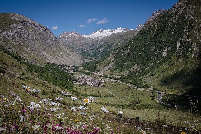
Balme is a charming village located in the Susa Valley of the Piedmont region in Italy. It's known for its breathtaking natural scenery, rugged terrain, and as a gateway to various hiking opportunities. Here are some key points about hiking in Balme:
Trail Variety
- Moderate to Difficult Trails: Balme offers a range of hiking trails suitable for different skill levels. Many trails can be quite challenging, making them ideal for experienced hikers looking for an adventure.
- Scenic Routes: The trails often pass through beautiful landscapes, including lush valleys, alpine meadows, and stunning views of the surrounding mountains.
Notable Hikes
- Path to the Touretta Peak: This hike offers fantastic panoramic views and is moderately challenging. The trail typically takes hikers through rich flora and fauna.
- Gran Paradiso National Park: Located not too far from Balme, this park features various trails, some starting from the village. It’s an amazing opportunity to see wildlife and enjoy the stunning mountain scenery.
Essential Tips
- Preparation: Be sure to check weather conditions before heading out and always carry appropriate gear, including sturdy hiking boots, sufficient water, and snacks.
- Local Guides: If you are unfamiliar with the area, consider hiring a local guide to navigate the trails and provide insights about the natural environment.
- Trail Marking: Be aware of trail markers to avoid getting lost, as some trails may not be as well-maintained or marked as others.
Access and Facilities
- Getting There: Balme can be accessed by car or bus from major towns in the Susa Valley. It's advisable to check transport schedules, especially in off-peak seasons.
- Accommodations: There are local accommodations, including guesthouses and lodges, for those who want to stay overnight and enjoy multiple days of hiking.
Safety Considerations
- Always inform someone of your hiking plans and expected return time.
- Carry a map or GPS device, especially if venturing on lesser-known trails.
- Be mindful of altitude and weather changes, as conditions can shift rapidly in mountainous areas.
Whether you're an experienced hiker or just looking for a day out in nature, Balme provides a stunning backdrop for hiking and exploring the beautiful Italian Alps.
- Country:

- Postal Code: 10070
- Local Dialing Code: 0123
- Licence Plate Code: TO
- Coordinates: 45° 18' 0" N, 7° 13' 0" E


- GPS tracks (wikiloc): [Link]
- AboveSeaLevel: 1432 м m
- Area: 62.71 sq km
- Population: 111
- Web site: http://www.comune.balme.to.it/
- Wikipedia en: wiki(en)
- Wikipedia: wiki(it)
- Wikidata storage: Wikidata: Q9028
- Wikipedia Commons Category: [Link]
- Freebase ID: [/m/0g6s8t]
- GeoNames ID: Alt: [6537019]
- VIAF ID: Alt: [233910972]
- OSM relation ID: [44597]
- UN/LOCODE: [ITLBM]
- ISTAT ID: 001019
- Italian cadastre code: A599
Shares border with regions:


Usseglio
- Italian comune
Usseglio, located in the Susa Valley in the Piedmont region of Italy, is a beautiful destination for hikers and outdoor enthusiasts. Known for its stunning alpine scenery, Usseglio offers a variety of trails that cater to different skill levels, making it an ideal spot for both beginners and experienced hikers....
- Country:

- Postal Code: 10070
- Local Dialing Code: 0123
- Licence Plate Code: TO
- Coordinates: 45° 14' 0" N, 7° 13' 0" E


- GPS tracks (wikiloc): [Link]
- AboveSeaLevel: 1260 м m
- Area: 98.54 sq km
- Population: 200
- Web site: [Link]


Bessans
- commune in Savoie, France
Bessans is a picturesque village located in the Savoie region of the French Alps, known for its stunning landscapes and outdoor activities, including hiking. Nestled at an altitude of about 1,740 meters, it offers a range of trails suitable for various skill levels, making it a great destination for both experienced hikers and families....
- Country:

- Postal Code: 73480
- Coordinates: 45° 19' 12" N, 6° 59' 37" E


- GPS tracks (wikiloc): [Link]
- AboveSeaLevel: 1750 м m
- Area: 128.08 sq km
- Population: 338
- Web site: [Link]


Bonneval-sur-Arc
- commune in Savoie, France
Bonneval-sur-Arc is a stunning location for hiking, situated in the French Alps within the Vanoise National Park. Known for its picturesque landscapes, high peaks, and well-preserved alpine environment, it offers a range of trails suitable for different levels of hikers....
- Country:

- Postal Code: 73480
- Coordinates: 45° 22' 16" N, 7° 2' 47" E


- GPS tracks (wikiloc): [Link]
- Area: 82.72 sq km
- Population: 255
- Web site: [Link]


Ala di Stura
- Italian comune
Ala di Stura is a picturesque town located in the Piedmont region of Italy, nestled within the beautiful natural scenery of the Alps. It’s known for its stunning landscapes, rich flora and fauna, and numerous trails that cater to hikers of all skill levels....
- Country:

- Postal Code: 10070
- Local Dialing Code: 0123
- Licence Plate Code: TO
- Coordinates: 45° 19' 0" N, 7° 18' 0" E


- GPS tracks (wikiloc): [Link]
- AboveSeaLevel: 1080 м m
- Area: 46.33 sq km
- Population: 456
- Web site: [Link]

Groscavallo
- Italian comune
Groscavallo is a beautiful area located in the Piedmont region of Italy, nestled in the Alps. Known for its stunning landscapes and natural beauty, it offers a variety of hiking opportunities for both beginners and experienced hikers....
- Country:

- Postal Code: 10070
- Local Dialing Code: 0123
- Licence Plate Code: TO
- Coordinates: 45° 22' 0" N, 7° 16' 0" E


- GPS tracks (wikiloc): [Link]
- AboveSeaLevel: 1110 м m
- Area: 92.09 sq km
- Population: 204
- Web site: [Link]


Lemie
- Italian comune
Lemie is a beautiful area located in the Susa Valley, in the Piedmont region of Italy. It's surrounded by stunning natural landscapes, making it an excellent destination for hiking enthusiasts. Here’s what you need to know about hiking in Lemie:...
- Country:

- Postal Code: 10070
- Local Dialing Code: 0123
- Licence Plate Code: TO
- Coordinates: 45° 14' 0" N, 7° 18' 0" E


- GPS tracks (wikiloc): [Link]
- AboveSeaLevel: 950 м m
- Area: 45.68 sq km
- Population: 189
- Web site: [Link]
