Baudrémont (Baudrémont)

- commune in Meuse, France
- Country:

- Postal Code: 55260
- Coordinates: 48° 50' 23" N, 5° 23' 16" E


- GPS tracks (wikiloc): [Link]
- Area: 6.81 sq km
- Population: 52
- Wikipedia en: wiki(en)
- Wikipedia: wiki(fr)
- Wikidata storage: Wikidata: Q678733
- Wikipedia Commons Category: [Link]
- Freebase ID: [/m/03qdp9p]
- GeoNames ID: Alt: [6449771]
- SIREN number: [215500323]
- BnF ID: [15264700b]
- INSEE municipality code: 55032
Shares border with regions:

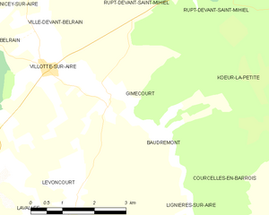
Gimécourt
- commune in Meuse, France
- Country:
- Postal Code: 55260
- Coordinates: 48° 50' 57" N, 5° 22' 7" E
- GPS tracks (wikiloc): [Link]
- Area: 10.12 sq km
- Population: 39


Lignières-sur-Aire
- commune in Meuse, France
- Country:
- Postal Code: 55260
- Coordinates: 48° 48' 32" N, 5° 22' 56" E
- GPS tracks (wikiloc): [Link]
- Area: 9.3 sq km
- Population: 52
Courcelles-en-Barrois
- commune in Meuse, France
- Country:
- Postal Code: 55260
- Coordinates: 48° 49' 30" N, 5° 26' 29" E
- GPS tracks (wikiloc): [Link]
- Area: 7.27 sq km
- Population: 35


Kœur-la-Petite
- commune in Meuse, France
- Country:
- Postal Code: 55300
- Coordinates: 48° 51' 19" N, 5° 29' 42" E
- GPS tracks (wikiloc): [Link]
- Area: 20.33 sq km
- Population: 301


Levoncourt
- commune in Meuse, France
- Country:
- Postal Code: 55260
- Coordinates: 48° 49' 23" N, 5° 21' 5" E
- GPS tracks (wikiloc): [Link]
- Area: 7.8 sq km
- Population: 57