Bazus-Aure (Bazus-Aure)

- commune in Hautes-Pyrénées, France
- Country:

- Postal Code: 65170
- Coordinates: 42° 51' 21" N, 0° 20' 57" E


- GPS tracks (wikiloc): [Link]
- Area: 1.95 sq km
- Population: 132
- Wikipedia en: wiki(en)
- Wikipedia: wiki(fr)
- Wikidata storage: Wikidata: Q1094187
- Wikipedia Commons Category: [Link]
- Freebase ID: [/m/03nv283]
- Freebase ID: [/m/03nv283]
- GeoNames ID: Alt: [6450480]
- GeoNames ID: Alt: [6450480]
- SIREN number: [216500751]
- SIREN number: [216500751]
- BnF ID: [15270456c]
- BnF ID: [15270456c]
- INSEE municipality code: 65075
- INSEE municipality code: 65075
Shares border with regions:

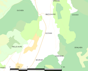
Guchan
- commune in Hautes-Pyrénées, France
- Country:
- Postal Code: 65170
- Coordinates: 42° 50' 50" N, 0° 20' 59" E
- GPS tracks (wikiloc): [Link]
- Area: 2.59 sq km
- Population: 136


Gouaux
- commune in Hautes-Pyrénées, France
- Country:
- Postal Code: 65440
- Coordinates: 42° 51' 54" N, 0° 21' 42" E
- GPS tracks (wikiloc): [Link]
- Area: 6.02 sq km
- Population: 63

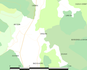
Grézian
- commune in Hautes-Pyrénées, France
- Country:
- Postal Code: 65440
- Coordinates: 42° 52' 8" N, 0° 21' 1" E
- GPS tracks (wikiloc): [Link]
- Area: 1.98 sq km
- Population: 90


Guchen
- commune in Hautes-Pyrénées, France
- Country:
- Postal Code: 65440
- Coordinates: 42° 51' 48" N, 0° 20' 14" E
- GPS tracks (wikiloc): [Link]
- AboveSeaLevel: 1205 м m
- Area: 5.55 sq km
- Population: 369