Beaumont-du-Lac (Beaumont-du-Lac)

- commune in Haute-Vienne, France
- Country:

- Postal Code: 87120
- Coordinates: 45° 46' 16" N, 1° 50' 5" E


- GPS tracks (wikiloc): [Link]
- Area: 23.91 sq km
- Population: 156
- Wikipedia en: wiki(en)
- Wikipedia: wiki(fr)
- Wikidata storage: Wikidata: Q196167
- Wikipedia Commons Category: [Link]
- Freebase ID: [/m/03nt_gb]
- GeoNames ID: Alt: [6617880]
- SIREN number: [218700904]
- BnF ID: [15278733g]
- VIAF ID: Alt: [233890033]
- INSEE municipality code: 87009
Shares border with regions:


Nedde
- commune in Haute-Vienne, France
- Country:
- Postal Code: 87120
- Coordinates: 45° 43' 9" N, 1° 49' 53" E
- GPS tracks (wikiloc): [Link]
- Area: 52.73 sq km
- Population: 475


Royère-de-Vassivière
- commune in Creuse, France
- Country:
- Postal Code: 23460
- Coordinates: 45° 50' 28" N, 1° 54' 41" E
- GPS tracks (wikiloc): [Link]
- Area: 74.14 sq km
- Population: 569

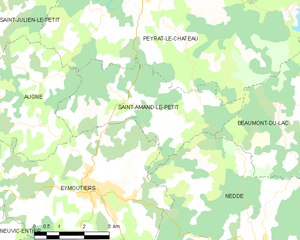
Saint-Amand-le-Petit
- commune in Haute-Vienne, France
- Country:
- Postal Code: 87120
- Coordinates: 45° 46' 29" N, 1° 45' 5" E
- GPS tracks (wikiloc): [Link]
- Area: 15.31 sq km
- Population: 99

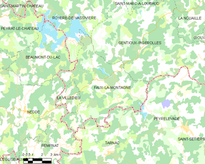
Faux-la-Montagne
- commune in Creuse, France
- Country:
- Postal Code: 23340
- Coordinates: 45° 45' 3" N, 1° 56' 5" E
- GPS tracks (wikiloc): [Link]
- Area: 47.89 sq km
- Population: 389
- Web site: [Link]


Peyrat-le-Château
- commune in Haute-Vienne, France
- Country:
- Postal Code: 87470
- Coordinates: 45° 48' 46" N, 1° 46' 22" E
- GPS tracks (wikiloc): [Link]
- Area: 52.96 sq km
- Population: 952