Faux-la-Montagne (Faux-la-Montagne)

- commune in Creuse, France
- Country:

- Postal Code: 23340
- Coordinates: 45° 45' 3" N, 1° 56' 5" E


- GPS tracks (wikiloc): [Link]
- Area: 47.89 sq km
- Population: 389
- Web site: http://fauxlamontagne.fr/
- Wikipedia en: wiki(en)
- Wikipedia: wiki(fr)
- Wikidata storage: Wikidata: Q204579
- Wikipedia Commons Category: [Link]
- Freebase ID: [/m/03mfj7x]
- Freebase ID: [/m/03mfj7x]
- GeoNames ID: Alt: [3018917]
- GeoNames ID: Alt: [3018917]
- SIREN number: [212307706]
- SIREN number: [212307706]
- BnF ID: [152514655]
- BnF ID: [152514655]
- archINFORM location ID: [8820]
- archINFORM location ID: [8820]
- INSEE municipality code: 23077
- INSEE municipality code: 23077
Shares border with regions:


La Villedieu
- commune in Creuse, France
- Country:
- Postal Code: 23340
- Coordinates: 45° 44' 1" N, 1° 53' 12" E
- GPS tracks (wikiloc): [Link]
- Area: 5.63 sq km
- Population: 49


Nedde
- commune in Haute-Vienne, France
- Country:
- Postal Code: 87120
- Coordinates: 45° 43' 9" N, 1° 49' 53" E
- GPS tracks (wikiloc): [Link]
- Area: 52.73 sq km
- Population: 475


Gentioux-Pigerolles
- commune in Creuse, France
- Country:
- Postal Code: 23340
- Coordinates: 45° 47' 4" N, 1° 59' 39" E
- GPS tracks (wikiloc): [Link]
- AboveSeaLevel: 800 м m
- Area: 79.29 sq km
- Population: 418


Royère-de-Vassivière
- commune in Creuse, France
- Country:
- Postal Code: 23460
- Coordinates: 45° 50' 28" N, 1° 54' 41" E
- GPS tracks (wikiloc): [Link]
- Area: 74.14 sq km
- Population: 569

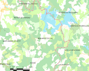
Beaumont-du-Lac
- commune in Haute-Vienne, France
- Country:
- Postal Code: 87120
- Coordinates: 45° 46' 16" N, 1° 50' 5" E
- GPS tracks (wikiloc): [Link]
- Area: 23.91 sq km
- Population: 156


Peyrelevade
- commune in Corrèze, France
- Country:
- Postal Code: 19290
- Coordinates: 45° 42' 14" N, 2° 3' 16" E
- GPS tracks (wikiloc): [Link]
- Area: 66.43 sq km
- Population: 799
- Web site: [Link]

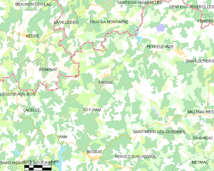
Tarnac
- commune in Corrèze, France
- Country:
- Postal Code: 19170
- Coordinates: 45° 40' 49" N, 1° 56' 49" E
- GPS tracks (wikiloc): [Link]
- Area: 67.46 sq km
- Population: 315

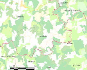
Rempnat
- commune in Haute-Vienne, France
- Country:
- Postal Code: 87120
- Coordinates: 45° 41' 13" N, 1° 53' 22" E
- GPS tracks (wikiloc): [Link]
- Area: 20.91 sq km
- Population: 145