Bellefonds (Bellefonds)

- commune in Vienne, France
- Country:

- Postal Code: 86210
- Coordinates: 46° 38' 47" N, 0° 35' 29" E


- GPS tracks (wikiloc): [Link]
- Area: 8.5 sq km
- Population: 252
- Wikipedia en: wiki(en)
- Wikipedia: wiki(fr)
- Wikidata storage: Wikidata: Q1359406
- Wikipedia Commons Category: [Link]
- Freebase ID: [/m/03qhgn0]
- GeoNames ID: Alt: [6451635]
- SIREN number: [218600203]
- BnF ID: [15278447b]
- INSEE municipality code: 86020
Shares border with regions:

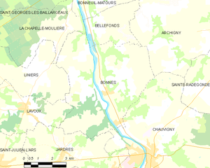
Bonnes
- commune in Vienne, France
- Country:
- Postal Code: 86300
- Coordinates: 46° 36' 14" N, 0° 35' 46" E
- GPS tracks (wikiloc): [Link]
- Area: 34.28 sq km
- Population: 1731


Bonneuil-Matours
- commune in Vienne, France
- Country:
- Postal Code: 86210
- Coordinates: 46° 40' 54" N, 0° 34' 13" E
- GPS tracks (wikiloc): [Link]
- Area: 42.8 sq km
- Population: 2117


Archigny
- commune in Vienne, France
- Country:
- Postal Code: 86210
- Coordinates: 46° 40' 23" N, 0° 39' 6" E
- GPS tracks (wikiloc): [Link]
- Area: 66.68 sq km
- Population: 1124
La Chapelle-Moulière
- commune in Vienne, France
- Country:
- Postal Code: 86210
- Coordinates: 46° 38' 58" N, 0° 33' 54" E
- GPS tracks (wikiloc): [Link]
- Area: 17.11 sq km
- Population: 683