Bernin (Bernin)
- commune in Isère, France
Hiking in the Bernina area, located in the eastern part of Switzerland, offers stunning views and diverse trails suitable for all levels of hikers. This region is part of the larger Bernina Range in the Alps and is known for its dramatic landscapes, including towering peaks, glaciers, and picturesque lakes.
Key Highlights:
-
Scenic Trails: There are numerous well-marked trails that cater to a range of abilities. You can find leisurely walks along lakes like Lake Bianco, challenging alpine hikes, or multi-day trekking options.
-
Piz Bernina: This is the highest peak in the Bernina Range and presents a challenge for experienced hikers and climbers. For those looking for a less strenuous option, guided tours or cable cars can take you closer to the mountain.
-
Routes: Popular hiking routes include:
- The Bernina Pass: Connects Engadin and Val Poschiavo and offers stunning views.
- The Morteratsch Glacier Trail: A relatively easy hike that gives you up-close access to the glacier.
- The Scree Trail: A scenic hike that takes you through diverse landscapes and offers beautiful views of the surrounding peaks.
-
Flora and Fauna: Hikers can enjoy a rich variety of flora and fauna. Keep an eye out for ibex, marmots, and a variety of alpine flowers, especially during the summer months.
-
Cultural Experience: The area is rich in culture, with charming villages like Pontresina and Ilanz, where you can enjoy local cuisines and traditions.
-
Best Time to Hike: The primary hiking season runs from late June to early October when the trails are generally clear of snow and the weather is more stable.
Tips for Hiking in Bernina:
- Weather Preparedness: The weather can change rapidly in the mountains, so be prepared with layers, waterproof gear, and sufficient food and water.
- Navigation Skills: While many trails are marked, having a map or GPS device can be invaluable, especially in more remote areas.
- Safety First: Consider your fitness level and experience. Some trails can be technically challenging and may require climbing equipment.
- Guided Tours: If you're unsure or it’s your first time in the Bernina area, consider hiring a local guide who can provide valuable insights and ensure your safety.
Overall, hiking in Bernina is a great way to experience the breathtaking beauty of the Swiss Alps while enjoying outdoor physical activity.
- Country:

- Postal Code: 38190
- Coordinates: 45° 16' 6" N, 5° 51' 54" E


- GPS tracks (wikiloc): [Link]
- Area: 7.67 sq km
- Population: 3122
- Web site: http://www.bernin.fr
- Wikipedia en: wiki(en)
- Wikipedia: wiki(fr)
- Wikidata storage: Wikidata: Q1008824
- Wikipedia Commons Category: [Link]
- Freebase ID: [/m/03g_71k]
- GeoNames ID: Alt: [6448727]
- SIREN number: [213800394]
- BnF ID: [15257868r]
- INSEE municipality code: 38039
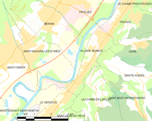
Shares border with regions:


Saint-Pancrasse
- commune in Isère, France
Saint-Pancrasse is a charming village located in the Isère department of the Auvergne-Rhône-Alpes region in southeastern France. Nestled in the foothills of the French Alps, it offers stunning scenery and a variety of hiking opportunities suitable for different skill levels....
- Country:

- Postal Code: 38660
- Coordinates: 45° 17' 31" N, 5° 51' 35" E


- GPS tracks (wikiloc): [Link]
- Area: 6.71 sq km
- Population: 442


Crolles
- commune in Isère, France
Crolles is a charming town located in the Auvergne-Rhône-Alpes region of France, nestled in the foothills of the Chartreuse mountains. It's a fantastic destination for hiking enthusiasts due to its stunning landscapes, diverse trails, and proximity to nature reserves....
- Country:

- Postal Code: 38920
- Coordinates: 45° 17' 6" N, 5° 52' 58" E


- GPS tracks (wikiloc): [Link]
- Area: 14.21 sq km
- Population: 8345
- Web site: [Link]


Saint-Nazaire-les-Eymes
- commune in Isère, France
 Hiking in Saint-Nazaire-les-Eymes
Saint-Nazaire-les-Eymes is a charming commune situated in the Auvergne-Rhône-Alpes region of southeastern France, near the French Alps. It offers a variety of hiking opportunities, making it a great destination for outdoor enthusiasts....
- Country:

- Postal Code: 38330
- Coordinates: 45° 14' 58" N, 5° 51' 12" E


- GPS tracks (wikiloc): [Link]
- AboveSeaLevel: 283 м m
- Area: 8.49 sq km
- Population: 2961
- Web site: [Link]


Villard-Bonnot
- commune in Isère, France
Villard-Bonnot, located in the French Alps near Grenoble, offers an excellent opportunity for hiking enthusiasts. With its picturesque landscapes, diverse trails, and stunning mountain views, the area is appealing to both beginners and experienced hikers....
- Country:

- Postal Code: 38190
- Coordinates: 45° 14' 17" N, 5° 53' 18" E


- GPS tracks (wikiloc): [Link]
- Area: 5.84 sq km
- Population: 7096
- Web site: [Link]
