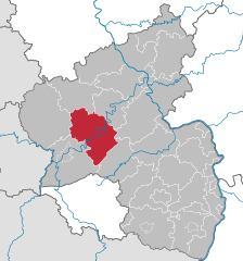
Bernkastel-Wittlich (Landkreis Bernkastel-Wittlich)
- district of Rhineland-Palatinate, Germany
Bernkastel-Wittlich, located in the Mosel valley of Germany, is a fantastic destination for hiking enthusiasts. The region is renowned for its beautiful vineyards, charming towns, and stunning views of the Mosel River. Here are some highlights of hiking in this area:
Scenic Trails
-
Moselsteig Trail: This is one of the most famous long-distance trails in the region, stretching approximately 365 kilometers along the Mosel River. Parts of the trail offer breathtaking views of the river, hills, and vineyards. The sections around Bernkastel-Kues are particularly picturesque.
-
Trierer Wanderweg: This trail offers a more local experience, showcasing the natural beauty of the surrounding countryside and vineyards.
-
Circular Trails: There are several circular hiking routes around Bernkastel-Wittlich that allow you to explore the landscape at a more leisurely pace. These trails often lead you through quaint villages and along the riverbank.
Attractions
-
Vineyards: As you hike, you'll pass through many vineyards, providing opportunities for wine tasting and learning about the winemaking process, particularly the region's famous Riesling.
-
Historic Towns: The charming towns of Bernkastel and Wittlich are rich in history, featuring half-timbered buildings, squares, and churches. You can plan hiking routes that include visits to these towns.
-
Views: Many of the hiking routes in the area offer stunning panoramic views of the Mosel River and the surrounding countryside. Don't forget your camera!
Practical Tips
-
Best Time to Hike: Spring and fall are ideal times for hiking, when the weather is mild, and the landscapes are particularly beautiful with lush greenery or autumn colors.
-
Equipment: Ensure you wear comfortable hiking shoes and bring water, snacks, and sunscreen. Depending on the trail, trekking poles may be useful.
-
Navigation: While many trails are well-marked, it’s a good idea to have a map or a GPS app to help navigate.
-
Guided Tours: If you're unfamiliar with the area or prefer a structured experience, consider joining a guided hiking tour, which can provide insights into the local culture, geology, and flora.
Enjoy your hiking adventure in Bernkastel-Wittlich! The combination of natural beauty, history, and local culture makes it a truly special place to explore on foot.
- Country:

- Licence Plate Code: WIL; BKS
- Coordinates: 49° 59' 13" N, 6° 53' 23" E


- GPS tracks (wikiloc): [Link]
- AboveSeaLevel: 337 м m
- Area: 1168.00 sq km
- Population: 110833
- Web site: http://www.bernkastel-wittlich.de/
- Wikipedia en: wiki(en)
- Wikipedia: wiki(de)
- Wikidata storage: Wikidata: Q8585
- Wikipedia Commons Category: [Link]
- Freebase ID: [/m/01f08b]
- GeoNames ID: Alt: [3247912]
- VIAF ID: Alt: [150140852]
- OSM relation ID: [62668]
- GND ID: Alt: [4005807-4]
- archINFORM location ID: [5116]
- Library of Congress authority ID: Alt: [n83318304]
- MusicBrainz area ID: [5f7ef372-6bbe-46ee-915f-abb21c4ea7e6]
- TGN ID: [7076962]
- NUTS code: [DEB22]
- German district key: 07231
Shares border with regions:
Rhein-Hunsrück-Kreis
- district of Rhineland-Palatinate, Germany
 Hiking in Rhein-Hunsrück-Kreis
Rhein-Hunsrück-Kreis, located in the Rhineland-Palatinate region of Germany, is an excellent destination for hiking enthusiasts. This area is characterized by its stunning natural landscapes, rolling hills, dense forests, and charming picturesque villages. Here are some highlights to consider when hiking in the Rhein-Hunsrück-Kreis:...
- Country:

- Licence Plate Code: SIM
- Coordinates: 50° 4' 48" N, 7° 30' 0" E


- GPS tracks (wikiloc): [Link]
- AboveSeaLevel: 429 м m
- Area: 990.7 sq km
- Web site: [Link]
