
Rhineland-Palatinate (Rheinland-Pfalz)


- state of Germany
 Hiking in Rhineland-Palatinate
Rhineland-Palatinate, located in western Germany, is a fantastic destination for hiking enthusiasts. This region is known for its diverse landscapes, ranging from the rolling vineyards of the Moselle Valley to the rugged terrain of the Eifel Mountains and the picturesque trails of the Rhine Gorge.
Key Features of Hiking in Rhineland-Palatinate:
-
Scenic Trails:
- Moselsteig Trail: A popular long-distance route that follows the Moselle River, featuring stunning vineyard views, charming towns, and historic castles.
- Rheinsteig Trail: A long-distance hike that runs along the Rhine River, offering breathtaking views of the river and wine country, as well as numerous castles along the way.
- Pfälzerwald Nature Park: Known for its dense forests and sandstone formations, this area provides an extensive network of hiking paths suitable for all skill levels.
-
Wine Hiking Trails: The region is famous for its vineyards, and several trails have been developed to allow hikers to explore the wine culture. Wine-tasting stops are often integrated into these trails.
-
Historical Sites: While hiking, you can discover various historical sites, including Roman ruins, medieval castles, and quaint towns like Cochem and Bacharach, which are rich in culture and history.
-
Variety of Difficulty Levels: Trails in Rhineland-Palatinate vary from easy, family-friendly walks to more challenging hikes that traverse rugged terrain. This makes it suitable for both novice hikers and seasoned adventurers.
-
Wildlife and Nature: The diverse ecosystems in Rhineland-Palatinate are home to a variety of wildlife. Hikers may encounter deer, wild boar, and numerous bird species, especially in nature parks.
-
Local Cuisine: After a day of hiking, exploring the local culinary delights is a must. Traditional dishes often feature regional ingredients, and the local wines are a highlight of the gastronomy.
Tips for Hiking in Rhineland-Palatinate:
- Weather Preparedness: The weather can be variable, so it’s wise to check forecasts and dress in layers. Always carry waterproof gear just in case.
- Navigation: While many trails are well-marked, having a map or a GPS device can enhance your exploration, especially in less developed areas.
- Timing: Spring and fall are ideal times for hiking, as temperatures are generally mild and the scenery is especially beautiful with blooming flowers or colorful autumn foliage.
- Respect Nature: As with all outdoor activities, please follow Leave No Trace principles to preserve the natural beauty of the area.
Rhineland-Palatinate offers something for everyone, whether you're seeking a leisurely stroll through vineyards or a challenging hike through rugged mountain trails. Happy hiking!
- Country:

- Capital: Mainz
- Coordinates: 49° 54' 47" N, 7° 26' 59" E


- GPS tracks (wikiloc): [Link]
- AboveSeaLevel: 0 м m
- Area: 19853.36 sq km
- Population: 4011582
- Web site: http://www.rlp.de/
- Wikipedia en: wiki(en)
- Wikipedia: wiki(de)
- Wikidata storage: Wikidata: Q1200
- Wikipedia Commons Gallery: [Link]
- Wikipedia Commons Category: [Link]
- Wikipedia Commons Maps Category: [Link]
- Freebase ID: [/m/06jtd]
- GeoNames ID: Alt: [2847618]
- BnF ID: [11939336g]
- VIAF ID: Alt: [123162663]
- OSM relation ID: [62341]
- GND ID: Alt: [4049795-1]
- archINFORM location ID: [2897]
- Library of Congress authority ID: Alt: [n81035110]
- PACTOLS thesaurus ID: [pcrtf8aRDZomsO]
- MusicBrainz area ID: [aa47eb3a-80b5-4837-a167-6d05a5f60714]
- Quora topic ID: [Rhineland-Palatinate]
- TGN ID: [7003682]
- SUDOC authorities ID: [026399792]
- Encyclopædia Britannica Online ID: [place/Rhineland-Palatinate]
- NKCR AUT ID: [ge134436]
- DMOZ ID: Alt: [Regional/Europe/Germany/States/Rhineland-Palatinate/]
- National Library of Israel ID: [000984260]
- NUTS code: [DEB]
- Klexikon article ID: [Rheinland-Pfalz]
- BabelNet ID: [01980513n]
- Global Anabaptist Mennonite Encyclopedia Online ID: [Rheinland-Pfalz (Germany)]
- FAST ID: [1212665]
- NE.se ID: [rheinland-pfalz]
- STW Thesaurus for Economics ID: [16909-1]
- ISO 3166-2 code: DE-RP
- German regional key: 07
- FIPS 10-4 (countries and regions): GM08
- GACS ID: 21352
Includes regions:

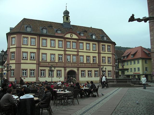
Pirmasens
- town in Rhineland-Palatinate, Germany
Hiking in Pirmasens
Pirmasens, located in the Palatinate Forest region of Germany, offers some fantastic hiking opportunities. The area is characterized by picturesque landscapes, forested hills, and scenic views, making it a great destination for outdoor enthusiasts....
- Country:
- Postal Code: 66955; 66954; 66953
- Local Dialing Code: 06331
- Licence Plate Code: PS
- Coordinates: 49° 12' 0" N, 7° 36' 0" E
- GPS tracks (wikiloc): [Link]
- AboveSeaLevel: 387 м m
- Area: 61.37 sq km
- Population: 40632
- Web site: [Link]


Zweibrücken
- town in Rhineland-Palatinate, Germany
Hiking in Zweibrücken
Zweibrücken, located in the southwestern part of Germany in the state of Rhineland-Palatinate, offers a variety of hiking opportunities for outdoor enthusiasts. The region is characterized by its picturesque landscapes, historic sites, and well-maintained trails, making it an attractive destination for both casual walkers and serious hikers....
- Country:
- Postal Code: 66482
- Local Dialing Code: 06337; 06332
- Licence Plate Code: ZW
- Coordinates: 49° 15' 29" N, 7° 22' 46" E
- GPS tracks (wikiloc): [Link]
- AboveSeaLevel: 300 м m
- Area: 70.64 sq km
- Population: 34270
- Web site: [Link]
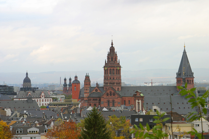

Mainz
- capital of the German state of Rhineland-Palatinate, Germany
Hiking in Mainz
Mainz, the capital of the Rhineland-Palatinate region in Germany, offers a variety of hiking opportunities, both within the city and in the surrounding countryside. Here are some aspects to consider when hiking in and around Mainz:...
- Country:
- Postal Code: 55001–55131
- Local Dialing Code: 06136; 06131
- Licence Plate Code: MZ
- Coordinates: 50° 0' 0" N, 8° 16' 0" E
- GPS tracks (wikiloc): [Link]
- AboveSeaLevel: 89 м m
- Area: 97.73 sq km
- Population: 213528
- Web site: [Link]
Montabaur Government Region
- regierungsbezirk in Rhineland-Palatinate, Germany
Hiking in Montabaur Government Region
Regierungsbezirk Montabaur, located in the Rhineland-Palatinate region of Germany, offers a variety of hiking opportunities that cater to different skill levels and interests. The region is characterized by its picturesque landscapes, including rolling hills, forests, and charming villages, making it an ideal destination for outdoor enthusiasts....
- Country:
Regierungsbezirk Pfalz
Hiking in Regierungsbezirk Pfalz
Regierungsbezirk Pfalz, located in the southwestern part of Germany, is known for its scenic landscapes, rich culture, and extensive hiking opportunities. This area is characterized by a mix of vineyards, forests, and mountainous regions, making it ideal for hikers of all levels. Here are some highlights and tips for hiking in the Pfalz region:...
- Country:
Rheinhessen Government Region
Hiking in Rheinhessen Government Region
Regierungsbezirk Rheinhessen, located in the state of Rhineland-Palatinate in Germany, is known for its beautiful landscapes, vineyards, and rolling hills, making it a fantastic area for hiking enthusiasts. Here's an overview of what you can expect when hiking in this region:...
- Country:


Ludwigshafen
- city in Rhineland-Palatinate, Germany
Hiking in Ludwigshafen
Ludwigshafen am Rhein, located in the German state of Rhineland-Palatinate, offers access to a variety of hiking opportunities in the surrounding areas. While the city itself is more industrial and urban, it's strategically positioned near natural attractions and hiking trails, especially along the Rhine River and in nearby forests and hills....
- Country:
- Postal Code: 67071; 67070; 67069; 67068; 67067; 67066; 67065; 67064; 67063; 67062; 67061; 67060; 67059
- Local Dialing Code: 06237; 0621
- Licence Plate Code: LU
- Coordinates: 49° 28' 52" N, 8° 26' 7" E
- GPS tracks (wikiloc): [Link]
- AboveSeaLevel: 96 м m
- Area: 77.43 sq km
- Population: 166621
- Web site: [Link]


Koblenz
- town in Rhineland-Palatinate, Germany
Hiking in Koblenz
Koblenz, located at the confluence of the Rhine and Moselle rivers in Germany, is a beautiful city that offers a variety of hiking opportunities for both beginners and experienced hikers. Here are some highlights and popular hiking routes in and around Koblenz:...
- Country:
- Postal Code: 56001–56077
- Local Dialing Code: 02606; 0261
- Licence Plate Code: KO
- Coordinates: 50° 21' 35" N, 7° 35' 52" E
- GPS tracks (wikiloc): [Link]
- AboveSeaLevel: 73 м m
- Area: 105020000 sq km
- Population: 112586
- Web site: [Link]


Trier
- town in Rhineland-Palatinate, Germany, oldest city in Germany
Hiking in Trier
Trier, located in Germany's Rhineland-Palatinate region, is a beautiful city known for its rich history and stunning landscapes. Surrounding the city are numerous hiking trails that offer both scenic views and opportunities to explore the area's natural beauty. Here are some highlights for hiking in the Trier area:...
- Country:
- Postal Code: 54296; 54295; 54294; 54293; 54292; 54290
- Local Dialing Code: 651
- Licence Plate Code: TR
- Coordinates: 49° 45' 24" N, 6° 38' 29" E
- GPS tracks (wikiloc): [Link]
- AboveSeaLevel: 135 м m
- Area: 117.07 sq km
- Population: 110111
- Web site: [Link]


Kaiserslautern
- town in Rhineland-Palatinate, Germany
Hiking in Kaiserslautern
Kaiserslautern, situated in the Palatinate region of Germany, offers a range of beautiful hiking opportunities for outdoor enthusiasts. The area is characterized by diverse landscapes, including forests, rolling hills, and picturesque vineyards. Here are some highlights for hiking in Kaiserslautern:...
- Country:
- Postal Code: 67655–67663; 67663; 67662; 67661; 67660; 67659; 67658; 67657; 67656; 67655; 6750
- Local Dialing Code: 0631; 06301
- Licence Plate Code: KL
- Coordinates: 49° 26' 41" N, 7° 46' 8" E
- GPS tracks (wikiloc): [Link]
- AboveSeaLevel: 251 м m
- Area: 139.72 sq km
- Population: 99684
- Web site: [Link]


Worms
- town in Rhineland-Palatinate, Germany
Hiking in Worms
Worms, Germany, is a city rich in history and culture, and while it is not primarily known as a hiking destination, it offers several pleasant walking and hiking opportunities in and around the area. Here are some aspects to consider when hiking in and around Worms:...
- Country:
- Postal Code: 67551; 67550; 67549; 67547
- Local Dialing Code: 06247; 06246; 06242; 06241
- Licence Plate Code: WO
- Coordinates: 49° 37' 55" N, 8° 21' 55" E
- GPS tracks (wikiloc): [Link]
- AboveSeaLevel: 100 м m
- Area: 108.73 sq km
- Population: 83081
- Web site: [Link]

Neustadt an der Weinstraße
- town in Rhineland-Palatinate, Germany
Hiking in Neustadt an der Weinstraße
Neustadt an der Weinstraße, located in the Rhineland-Palatinate region of Germany, is a beautiful destination for hiking enthusiasts. Nestled in the vineyards of the Palatinate Wine Region, this area offers a variety of hiking trails that cater to different skill levels and preferences....
- Country:
- Postal Code: 67435; 67434; 67433; 6730
- Local Dialing Code: 06327; 06321
- Licence Plate Code: NW
- Coordinates: 49° 20' 47" N, 8° 8' 57" E
- GPS tracks (wikiloc): [Link]
- AboveSeaLevel: 144 м m
- Area: 117.09 sq km
- Population: 53353
- Web site: [Link]
Rheinhessen-Pfalz
- government region of Germany
Hiking in Rheinhessen-Pfalz
Rheinhessen-Pfalz, located in the southwestern part of Germany, offers a diverse and scenic hiking experience. This region is notable for its picturesque vineyards, rolling hills, and charming villages, making it an attractive destination for both casual walkers and avid hikers....
- Country:
- Coordinates: 49° 21' 0" N, 8° 9' 0" E
- GPS tracks (wikiloc): [Link]
Trier Government Region
- Trier (region)
Hiking in Trier Government Region
Trier, located in the Moselle Valley in Germany, is known for its rich history and beautiful landscapes, making it a fantastic destination for hiking enthusiasts. Here are some highlights about hiking in the Trier region:...
Koblenz Government Region
- government region of Germany
Hiking in Koblenz Government Region
Koblenz, located at the confluence of the Rhine and Moselle rivers in Germany, is a beautiful region with a rich history and stunning landscapes, making it an excellent destination for hiking enthusiasts. Here are some highlights and trails you might consider when hiking in the Koblenz region:...
- Country:
- Coordinates: 50° 22' 0" N, 7° 36' 0" E
- GPS tracks (wikiloc): [Link]


Speyer
- town in Rhineland-Palatinate, Germany
Hiking in Speyer
Speyer, located in the state of Rhineland-Palatinate in Germany, is an excellent base for hiking enthusiasts. The region offers a variety of trails and scenic landscapes, from lush vineyards to the picturesque countryside and nearby forested areas. Here are some highlights and tips for hiking in and around Speyer:...
- Country:
- Postal Code: 67346; 6720
- Local Dialing Code: 06232
- Licence Plate Code: SP
- Coordinates: 49° 19' 10" N, 8° 25' 52" E
- GPS tracks (wikiloc): [Link]
- AboveSeaLevel: 113 м m
- Area: 42.58 sq km
- Population: 50931
- Web site: [Link]


Frankenthal
- town in Rhineland-Palatinate, Germany
Hiking in Frankenthal
Frankenthal, a city located in the Rhineland-Palatinate region of Germany, is not primarily known for hiking compared to more mountainous areas of the country. However, it offers several opportunities for walking and hiking enthusiasts, particularly in the surrounding nature areas and the nearby Palatinate Forest....
- Country:
- Postal Code: 67227
- Local Dialing Code: 06233
- Licence Plate Code: FT
- Coordinates: 49° 32' 0" N, 8° 21' 0" E
- GPS tracks (wikiloc): [Link]
- AboveSeaLevel: 96 м m
- Area: 43.88 sq km
- Population: 48445
- Web site: [Link]


Landau in der Pfalz
- town in Rhineland-Palatinate, Germany
Hiking in Landau in der Pfalz
Landau, located in the Rhineland-Palatinate region of Germany, offers a variety of hiking opportunities that showcase the area's natural beauty, vineyards, and picturesque landscapes. Here are some highlights for hiking in and around Landau:...
- Country:
- Postal Code: 76857; 76829
- Local Dialing Code: 06345; 06341
- Licence Plate Code: LD
- Coordinates: 49° 11' 58" N, 8° 7' 23" E
- GPS tracks (wikiloc): [Link]
- AboveSeaLevel: 142 м m
- Area: 82.94 sq km
- Population: 46292
- Web site: [Link]
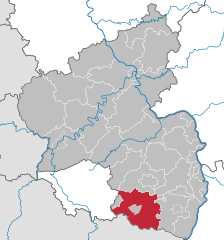
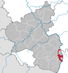
Germersheim
- district of Rhineland-Palatinate, Germany
Hiking in Germersheim
Germersheim, located in the Rhineland-Palatinate region of Germany, offers a variety of hiking opportunities that cater to different skill levels and preferences. The landscape is characterized by rolling hills, forests, and stretches of the Rhine River, providing both scenic beauty and diverse terrain for hikers....
- Country:
- Licence Plate Code: GER
- Coordinates: 49° 4' 48" N, 8° 15' 0" E
- GPS tracks (wikiloc): [Link]
- AboveSeaLevel: 107 м m
- Area: 463.26 sq km
- Population: 124889
- Web site: [Link]
Südliche Weinstraße
- district of Rhineland-Palatinate, Germany
Hiking in Südliche Weinstraße
Südliche Weinstraße, or the Southern Wine Route, is a picturesque area in the Palatinate region of Germany, known for its vineyards, charming villages, and scenic landscapes. Hiking in this region offers a fantastic way to explore its natural beauty and cultural heritage. Here are some highlights:...
- Country:
- Capital: Landau in der Pfalz
- Licence Plate Code: SÜW
- Coordinates: 49° 10' 12" N, 8° 0' 0" E
- GPS tracks (wikiloc): [Link]
- AboveSeaLevel: 201 м m
- Area: 639.89 sq km
- Population: 108752
- Web site: [Link]
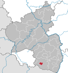
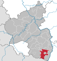
Südwestpfalz
- district of Rhineland-Palatinate, Germany
Hiking in Südwestpfalz
Südwestpfalz, located in the southwestern part of Germany, is a beautiful region that offers a variety of hiking opportunities for outdoor enthusiasts. The area's landscape is characterized by rolling hills, dense forests, and picturesque valleys, making it an ideal destination for hikers of all skill levels....
- Country:
- Capital: Pirmasens
- Licence Plate Code: PS
- Coordinates: 49° 12' 0" N, 7° 35' 0" E
- GPS tracks (wikiloc): [Link]
- AboveSeaLevel: 358 м m
- Web site: [Link]
Rhein-Pfalz-Kreis
- district of Rhineland-Palatinate, Germany
Hiking in Rhein-Pfalz-Kreis
Rhein-Pfalz-Kreis, located in the state of Rhineland-Palatinate in Germany, is a fantastic area for hiking enthusiasts. With its picturesque landscapes, rolling hills, vineyards, and charming villages, this region offers a variety of trails suitable for all skill levels. Here’s an overview of what you can expect when hiking in Rhein-Pfalz-Kreis:...
- Country:
- Capital: Ludwigshafen
- Licence Plate Code: RP
- Coordinates: 49° 25' 12" N, 8° 19' 48" E
- GPS tracks (wikiloc): [Link]
- AboveSeaLevel: 95 м m
- Web site: [Link]
Bad Dürkheim
- district of Rhineland-Palatinate, Germany
Hiking in Bad Dürkheim
Bad Dürkheim, located in the Rhineland-Palatinate region of Germany, is an excellent destination for hiking enthusiasts. This district is not only known for its scenic landscapes but also for its wines and thermal springs. Here are some highlights about hiking in Bad Dürkheim:...
- Country:
- Coordinates: 49° 30' 0" N, 8° 10' 12" E
- GPS tracks (wikiloc): [Link]
- AboveSeaLevel: 239 м m
- Area: 595.00 sq km
- Population: 130927
- Web site: [Link]
Landkreis Kaiserslautern
- district of Rhineland-Palatinate, Germany
Hiking in Landkreis Kaiserslautern
Kaiserslautern, located in the state of Rhineland-Palatinate, Germany, is an excellent region for hiking enthusiasts. The area is surrounded by beautiful landscapes, including forests, hills, and valleys, making it ideal for outdoor activities....
- Country:
- Licence Plate Code: KL
- Coordinates: 49° 30' 0" N, 7° 40' 12" E
- GPS tracks (wikiloc): [Link]
- AboveSeaLevel: 267 м m
- Area: 639.85 sq km
- Population: 104443
- Web site: [Link]
Kusel
- district of Rhineland-Palatinate, Germany
Hiking in Kusel
Kusel is a district in the Rhineland-Palatinate region of Germany, known for its picturesque countryside, rolling hills, and diverse landscapes that make it an attractive destination for hiking enthusiasts. Here are some key highlights and popular hiking options in the Kusel district:...
- Country:
- Licence Plate Code: KUS
- Coordinates: 49° 34' 48" N, 7° 30' 0" E
- GPS tracks (wikiloc): [Link]
- AboveSeaLevel: 338 м m
- Area: 573.42 sq km
- Population: 71766
- Web site: [Link]
Donnersbergkreis
- district of Rhineland-Palatinate, Germany
Hiking in Donnersbergkreis
Donnersbergkreis is a beautiful region in Germany known for its stunning landscapes, rich history, and a variety of hiking opportunities. Located in the state of Rhineland-Palatinate, this area features the Donnersberg mountain, which is the highest peak in the Palatinate region at an elevation of 687 meters (2,254 feet). Here’s what you can expect when hiking in this area:...
- Country:
- Licence Plate Code: KIB
- Coordinates: 49° 38' 0" N, 7° 55' 0" E
- GPS tracks (wikiloc): [Link]
- AboveSeaLevel: 570 м m
- Area: 645.46 sq km
- Population: 75508
- Web site: [Link]
Alzey-Worms
- district of Rhineland-Palatinate, Germany
Hiking in Alzey-Worms
Alzey-Worms is a district located in Rhineland-Palatinate, Germany, and it offers some beautiful landscapes and hiking opportunities. Here are some key points about hiking in this region:...
- Country:
- Licence Plate Code: AZ
- Coordinates: 49° 40' 12" N, 8° 15' 0" E
- GPS tracks (wikiloc): [Link]
- AboveSeaLevel: 179 м m
- Area: 588.00 sq km
- Population: 125173
- Web site: [Link]
Mainz-Bingen
- district of Rhineland-Palatinate, Germany
Hiking in Mainz-Bingen
Mainz-Bingen, situated in the scenic Rhineland-Palatinate region of Germany, is an excellent destination for hiking enthusiasts. The area boasts a mix of beautiful landscapes, including vineyards, hills, rivers, and charming villages, making it a great place for both casual walkers and serious hikers....
- Country:
- Licence Plate Code: MZ; BIN
- Coordinates: 49° 55' 12" N, 8° 4' 48" E
- GPS tracks (wikiloc): [Link]
- AboveSeaLevel: 201 м m
- Area: 605.85 sq km
- Population: 202222
- Web site: [Link]
Bad Kreuznach
- district of Rhineland-Palatinate, Germany
Hiking in Bad Kreuznach
Bad Kreuznach, located in Rhineland-Palatinate, Germany, offers a variety of hiking opportunities that showcase the region's natural beauty, diverse landscapes, and rich history. Here are some key highlights for hiking in Bad Kreuznach (district):...
- Country:
- Licence Plate Code: KH
- Coordinates: 49° 49' 48" N, 7° 49' 48" E
- GPS tracks (wikiloc): [Link]
- AboveSeaLevel: 265 м m
- Area: 863.72 sq km
- Population: 155306
- Web site: [Link]
Rhein-Hunsrück-Kreis
- district of Rhineland-Palatinate, Germany
Hiking in Rhein-Hunsrück-Kreis
Rhein-Hunsrück-Kreis, located in the Rhineland-Palatinate region of Germany, is an excellent destination for hiking enthusiasts. This area is characterized by its stunning natural landscapes, rolling hills, dense forests, and charming picturesque villages. Here are some highlights to consider when hiking in the Rhein-Hunsrück-Kreis:...
- Country:
- Licence Plate Code: SIM
- Coordinates: 50° 4' 48" N, 7° 30' 0" E
- GPS tracks (wikiloc): [Link]
- AboveSeaLevel: 429 м m
- Area: 990.7 sq km
- Web site: [Link]

Birkenfeld
- district of Rhineland-Palatinate, Germany
Hiking in Birkenfeld
Birkenfeld is a district located in the state of Rhineland-Palatinate, Germany, and is known for its beautiful landscapes and hiking opportunities. The region features a mix of forests, hills, and valleys that offer various trails suitable for hikers of all experience levels....
- Country:
- Licence Plate Code: BIR
- Coordinates: 49° 40' 12" N, 7° 19' 48" E
- GPS tracks (wikiloc): [Link]
- AboveSeaLevel: 411 м m
- Area: 777.00 sq km
- Population: 81135
- Web site: [Link]

Trier-Saarburg
- district of Rhineland-Palatinate, Germany
Hiking in Trier-Saarburg
Trier-Saarburg is a beautiful region in Germany that offers stunning landscapes, rich history, and a variety of hiking trails suitable for all experience levels. Located at the confluence of the Moselle and Saar rivers, this area is not only picturesque but also culturally significant, making it a great destination for outdoor enthusiasts....
- Country:
- Capital: Trier
- Licence Plate Code: TR; SAB
- Coordinates: 49° 40' 12" N, 6° 40' 12" E
- GPS tracks (wikiloc): [Link]
- AboveSeaLevel: 307 м m
- Area: 1101.00 sq km
- Population: 143893
- Web site: [Link]
Eifelkreis Bitburg-Prüm
- district of Rhineland-Palatinate, Germany
Hiking in Eifelkreis Bitburg-Prüm
Bitburg-Prüm is a lovely region located in the Eifel area of Germany, renowned for its beautiful landscapes, charming villages, and rich history, making it an excellent destination for hikers. Here are some highlights and tips for hiking in this picturesque area:...
- Country:
- Licence Plate Code: BIT
- Coordinates: 50° 0' 0" N, 6° 25' 12" E
- GPS tracks (wikiloc): [Link]
- AboveSeaLevel: 340 м m
- Area: 1626.12 sq km
- Population: 95946
- Web site: [Link]
Vulkaneifel
- district of Rhineland-Palatinate, Germany
Hiking in Vulkaneifel
Vulkaneifel is a captivating hiking destination located in the Eifel region of Germany, known for its volcanic landscapes, unique geological features, and rich biodiversity. Here are some key points to consider when planning a hiking trip to Vulkaneifel:...
- Country:
- Licence Plate Code: DAU
- Coordinates: 50° 15' 0" N, 6° 45' 0" E
- GPS tracks (wikiloc): [Link]
- AboveSeaLevel: 530 м m
- Web site: [Link]
Bernkastel-Wittlich
- district of Rhineland-Palatinate, Germany
Hiking in Bernkastel-Wittlich
Bernkastel-Wittlich, located in the Mosel valley of Germany, is a fantastic destination for hiking enthusiasts. The region is renowned for its beautiful vineyards, charming towns, and stunning views of the Mosel River. Here are some highlights of hiking in this area:...
- Country:
- Licence Plate Code: WIL; BKS
- Coordinates: 49° 59' 13" N, 6° 53' 23" E
- GPS tracks (wikiloc): [Link]
- AboveSeaLevel: 337 м m
- Area: 1168.00 sq km
- Population: 110833
- Web site: [Link]
Cochem-Zell
- district of Rhineland-Palatinate, Germany
Hiking in Cochem-Zell
Cochem-Zell is a beautiful region located in the Moselle Valley of Germany, known for its picturesque landscapes, charming villages, and vineyards. It's a fantastic destination for hiking enthusiasts of all experience levels. Here are some highlights to consider while hiking in Cochem-Zell:...
- Country:
- Licence Plate Code: ZEL; COC
- Coordinates: 50° 10' 12" N, 7° 10' 12" E
- GPS tracks (wikiloc): [Link]
- AboveSeaLevel: 284 м m
- Area: 691.82 sq km
- Population: 63475
- Web site: [Link]

Mayen-Koblenz
- district of Rhineland-Palatinate, Germany
Hiking in Mayen-Koblenz
Mayen-Koblenz, located in the heart of the Rhineland-Palatinate region of Germany, offers some stunning hiking opportunities for outdoor enthusiasts. Here are some details about hiking in this picturesque area:...
- Country:
- Capital: Koblenz
- Licence Plate Code: MYK; MY
- Coordinates: 50° 19' 48" N, 7° 19' 48" E
- GPS tracks (wikiloc): [Link]
- AboveSeaLevel: 223 м m
- Area: 817.10 sq km
- Population: 210035
- Web site: [Link]


Ahrweiler
- district of Rhineland-Palatinate, Germany
Hiking in Ahrweiler
Ahrweiler, located in the Rhineland-Palatinate region of Germany, is a fantastic area for hiking, thanks to its stunning landscapes, picturesque vineyards, and scenic river valleys. The district is part of the Ahr Valley, known for its wine production, particularly red wines from the Spätburgunder grape....
- Country:
- Capital: Bad Neuenahr-Ahrweiler
- Licence Plate Code: AW
- Coordinates: 50° 32' 0" N, 7° 5' 0" E
- GPS tracks (wikiloc): [Link]
- AboveSeaLevel: 331 м m
- Area: 787.00 sq km
- Population: 125837
- Web site: [Link]


Rhein-Lahn-Kreis
- district of Rhineland-Palatinate, Germany
Hiking in Rhein-Lahn-Kreis
Rhein-Lahn-Kreis, located in the picturesque region of Rhineland-Palatinate in Germany, offers a diverse range of hiking opportunities set against the backdrop of stunning landscapes, historic castles, and quaint villages. Here are some key aspects of hiking in the area:...
- Country:
- Capital: Bad Ems
- Licence Plate Code: EMS
- Coordinates: 50° 16' 0" N, 7° 52' 0" E
- GPS tracks (wikiloc): [Link]
- AboveSeaLevel: 275 м m
- Web site: [Link]
Westerwaldkreis
- district of Rhineland-Palatinate, Germany
Hiking in Westerwaldkreis
Westerwaldkreis, located in the heart of Germany, is a charming district known for its scenic landscapes and diverse hiking trails. The region features a mix of woodlands, rolling hills, and valleys, making it an excellent destination for hikers of all levels. Here are some highlights about hiking in Westerwaldkreis:...
- Country:
- Licence Plate Code: WW
- Coordinates: 50° 31' 0" N, 7° 52' 0" E
- GPS tracks (wikiloc): [Link]
- AboveSeaLevel: 437 м m
- Web site: [Link]
Neuwied
- district of Rhineland-Palatinate, Germany
Hiking in Neuwied
Neuwied, located in the state of Rhineland-Palatinate in Germany, offers a variety of hiking opportunities that cater to different skill levels and preferences. The district is characterized by its beautiful landscapes, including the scenic banks of the Rhine River, rolling hills, and lush forests, making it an appealing spot for outdoor enthusiasts....
- Country:
- Licence Plate Code: NR
- Coordinates: 50° 30' 0" N, 7° 30' 0" E
- GPS tracks (wikiloc): [Link]
- AboveSeaLevel: 388 м m
- Area: 626.80 sq km
- Population: 179812
- Web site: [Link]
Altenkirchen district
- district of Rhineland-Palatinate, Germany
Hiking in Altenkirchen district
Altenkirchen, located in the Rhineland-Palatinate region of Germany, offers a variety of hiking opportunities in a picturesque rural setting. The district is characterized by rolling hills, forests, and scenic landscapes, making it an excellent destination for both casual walkers and more experienced hikers....
- Country:
- Licence Plate Code: AK
- Coordinates: 50° 45' 0" N, 7° 45' 0" E
- GPS tracks (wikiloc): [Link]
- AboveSeaLevel: 157 м m
- Area: 642.00 sq km
- Population: 129166
- Web site: [Link]
Shares border with regions:

North Rhine-Westphalia
- state of Germany
Hiking in North Rhine-Westphalia
North Rhine-Westphalia (NRW) is a fantastic region for hiking enthusiasts, offering a diverse range of landscapes, trails, and experiences. Here’s what you can expect when hiking in this beautiful German state:...
- Country:
- Capital: Düsseldorf
- Coordinates: 51° 28' 0" N, 7° 33' 0" E
- GPS tracks (wikiloc): [Link]
- AboveSeaLevel: 45 м m
- Area: 34112.52 sq km
- Population: 17572000
- Web site: [Link]


Hesse
- state in Germany
Hiking in Hesse
Hesse, located in central Germany, offers a diverse range of hiking opportunities, thanks to its varied landscapes that include forests, hills, and charming villages. Here are some highlights of hiking in the region:...
- Country:
- Capital: Wiesbaden
- Coordinates: 50° 39' 58" N, 8° 35' 28" E
- GPS tracks (wikiloc): [Link]
- AboveSeaLevel: 264 м m
- Area: 21100.0 sq km
- Population: 6045425
- Web site: [Link]


Saarland
- state of Germany
Hiking in Saarland
Saarland, one of the smaller states in Germany, offers a range of beautiful hiking opportunities, combining lush landscapes, historical sites, and charming villages. Here's a brief overview of what to expect when hiking in Saarland:...
- Country:
- Capital: Saarbrücken
- Coordinates: 49° 22' 38" N, 6° 52' 42" E
- GPS tracks (wikiloc): [Link]
- Area: 2570.0 sq km
- Population: 995597
- Web site: [Link]


Moselle
- French department
- Country:

- Capital: Metz
- Coordinates: 49° 2' 2" N, 6° 39' 43" E
- GPS tracks (wikiloc): [Link]
- Area: 6216 sq km
- Population: 1044486
- Web site: [Link]


Bas-Rhin
- French department
- Country:
- Capital: Strasbourg
- Coordinates: 48° 49' 0" N, 7° 47' 0" E
- GPS tracks (wikiloc): [Link]
- Area: 4755 sq km
- Population: 1121407
- Web site: [Link]


Baden-Württemberg
- federal state in the South-West of Germany
Hiking in Baden-Württemberg
Baden-Württemberg, located in southwestern Germany, is a fantastic region for hiking enthusiasts. With its diverse landscapes, from the Black Forest to the Swabian Jura and picturesque vineyards along the Rhine River, the area offers a variety of trails suitable for all skill levels. Here are some highlights:...
- Country:
- Capital: Stuttgart
- Coordinates: 48° 32' 16" N, 9° 2' 28" E
- GPS tracks (wikiloc): [Link]
- AboveSeaLevel: 327 м m
- Area: 35751.65 sq km
- Population: 10703000
- Web site: [Link]