Bernon (Bernon)

- commune in Aube, France
- Country:

- Postal Code: 10130
- Coordinates: 47° 59' 18" N, 3° 59' 43" E


- GPS tracks (wikiloc): [Link]
- Area: 17.91 sq km
- Population: 183
- Wikipedia en: wiki(en)
- Wikipedia: wiki(fr)
- Wikidata storage: Wikidata: Q1146684
- Wikipedia Commons Category: [Link]
- Freebase ID: [/m/03m8qjr]
- GeoNames ID: Alt: [6446928]
- SIREN number: [211000369]
- BnF ID: [15246133q]
- INSEE municipality code: 10040
Shares border with regions:

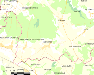
Lignières
- commune in Aube, France
- Country:
- Postal Code: 10130
- Coordinates: 47° 57' 7" N, 3° 57' 59" E
- GPS tracks (wikiloc): [Link]
- Area: 25.79 sq km
- Population: 225


Coussegrey
- commune in Aube, France
- Country:
- Postal Code: 10210
- Coordinates: 47° 57' 18" N, 4° 1' 2" E
- GPS tracks (wikiloc): [Link]
- Area: 16.16 sq km
- Population: 191


Chessy-les-Prés
- commune in Aube, France
- Country:
- Postal Code: 10130
- Coordinates: 48° 1' 28" N, 3° 54' 52" E
- GPS tracks (wikiloc): [Link]
- Area: 25.69 sq km
- Population: 511


Vanlay
- commune in Aube, France
- Country:
- Postal Code: 10210
- Coordinates: 48° 1' 39" N, 4° 1' 4" E
- GPS tracks (wikiloc): [Link]
- Area: 25.91 sq km
- Population: 312