Bethoncourt (Bethoncourt)

- commune in Doubs, France
 Hiking in Bethoncourt
Bethoncourt is a small commune located in the Doubs department in the Bourgogne-Franche-Comté region of eastern France. While it's not as widely known for hiking as some of the larger national parks or tourist destinations, it still offers opportunities for outdoor enthusiasts to explore the nearby countryside.
Hiking Opportunities
-
Local Trails: The area around Bethoncourt features scenic rural trails that can be ideal for leisurely hikes. These might include paths through forests, fields, and along rivers, giving hikers a chance to enjoy the natural beauty of the region.
-
Nearby Nature Reserves: Consider venturing a short drive from Bethoncourt to explore local nature reserves or parks. The nearby Doubs valley, for example, is known for its stunning landscapes and could provide more structured hiking paths.
-
Franche-Comté Region: This broader region includes the Jura Mountains and the Doubs River, which are both excellent for hiking. You can find various trails of differing difficulty levels, ranging from easy walks to more challenging hikes.
Tips for Hiking in Bethoncourt
-
Weather: Always check the weather forecast before heading out. The region can experience varied weather conditions, and it's best to be prepared.
-
Trail Maps: If you're hiking in more remote areas, it might be helpful to have a map or GPS device. Local tourist offices often have trail maps available.
-
Safety: Make sure to have proper hiking attire, sturdy footwear, and enough water and snacks, especially if you're going on longer hikes.
-
Wildlife: Be mindful of local wildlife and plants. Respect the natural environment and follow any guidelines regarding wildlife observation.
-
Cultural Heritage: Enjoy the cultural aspects of the region as well. You may come across historical sites or local villages that add to your hiking experience.
If you're planning a visit to Bethoncourt primarily for hiking, consider combining it with exploration of the surrounding areas to maximize your outdoor experience. Happy hiking!
- Country:

- Postal Code: 25200
- Coordinates: 47° 32' 4" N, 6° 48' 14" E


- GPS tracks (wikiloc): [Link]
- Area: 6.54 sq km
- Population: 5652
- Web site: http://www.bethoncourt.fr
- Wikipedia en: wiki(en)
- Wikipedia: wiki(fr)
- Wikidata storage: Wikidata: Q831409
- Wikipedia Commons Category: [Link]
- Freebase ID: [/m/03mgc86]
- Freebase ID: [/m/03mgc86]
- GeoNames ID: Alt: [3033006]
- GeoNames ID: Alt: [3033006]
- SIREN number: [212500573]
- SIREN number: [212500573]
- BnF ID: [15252283s]
- BnF ID: [15252283s]
- PACTOLS thesaurus ID: [pcrtDv0Mxds8Oe]
- PACTOLS thesaurus ID: [pcrtDv0Mxds8Oe]
- INSEE municipality code: 25057
- INSEE municipality code: 25057
Shares border with regions:
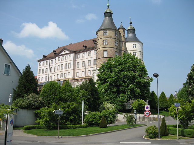

Montbéliard
- commune in Doubs, France
Hiking in Montbéliard
Montbéliard, a picturesque town located in the Bourgogne-Franche-Comté region of eastern France, offers various hiking opportunities that allow you to explore the beautiful landscapes and rich history of the area....
- Country:
- Postal Code: 25200
- Coordinates: 47° 30' 35" N, 6° 47' 54" E
- GPS tracks (wikiloc): [Link]
- AboveSeaLevel: 337 м m
- Area: 15.01 sq km
- Population: 25336
- Web site: [Link]
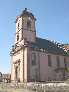

Châtenois-les-Forges
- commune in Territoire de Belfort, France
Hiking in Châtenois-les-Forges
Châtenois-les-Forges is a charming village located in the Vosges department of northeastern France. It's surrounded by beautiful natural landscapes, making it a great spot for hiking enthusiasts. Here are some key points about hiking in this area:...
- Country:
- Postal Code: 90700
- Coordinates: 47° 33' 33" N, 6° 50' 54" E
- GPS tracks (wikiloc): [Link]
- Area: 8.67 sq km
- Population: 2757

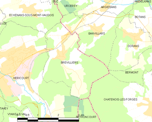
Brevilliers
- commune in Haute-Saône, France
Hiking in Brevilliers
Brevilliers is a small village located in the Doubs department of the Bourgogne-Franche-Comté region in eastern France. While it is not a well-known hiking destination, the surrounding area offers beautiful landscapes and trails that can be explored by hiking enthusiasts....
- Country:
- Postal Code: 70400
- Coordinates: 47° 34' 54" N, 6° 47' 32" E
- GPS tracks (wikiloc): [Link]
- Area: 6.47 sq km
- Population: 619