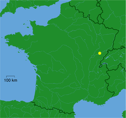
Beure (Beure)

- commune in Doubs, France
 Hiking in Beure
Beure, located in the Bourgogne-Franche-Comté region of France, offers some beautiful hiking opportunities, especially for those who appreciate scenic landscapes and natural beauty. While Beure itself is a small commune, it is situated near the Jura mountains, which provide various trails and outdoor experiences.
Hiking Trails in and around Beure:
-
Jura Mountains Trails: The nearby Jura mountain range features several hiking paths of varying difficulty. Trails range from easy walks to more challenging hikes, suitable for different fitness levels.
-
Plage de la Fignette: Near Beure, this area offers scenic views and access to lakes, perfect for a walk along water's edge. It’s a great spot for a relaxed hike or a picnic amid beautiful nature.
-
Les Rivières de Franche-Comté: This region is home to stunning rivers and nature reserves. Hiking along the riverbanks can offer both peaceful scenery and more challenging terrain, depending on the chosen route.
-
Local Flora and Fauna: Trails around Beure can provide opportunities to witness local wildlife and diverse plant life. Bring your binoculars for bird watching, or simply enjoy the natural surroundings.
Tips for Hiking in Beure:
- Seasonal Considerations: Check the weather and trail conditions, especially in spring and fall when the ground might be wet or muddy.
- Footwear: Wear sturdy hiking boots, as some trails may have uneven terrain or slippery areas.
- Hydration and Snacks: Always pack sufficient water and snacks, especially on longer hikes.
- Maps and Guides: Consider using local hiking maps or apps to keep track of trails and points of interest.
- Respect Nature: Stay on marked trails to protect the local environment and practice Leave No Trace principles.
Concluding Suggestion:
Whether you are looking for a leisurely stroll or a more rigorous hiking experience, Beure and its surroundings can provide a delightful escape into nature. Always ensure to plan ahead, prepare adequately, and most importantly, enjoy your outdoor adventure!
- Country:

- Postal Code: 25720
- Coordinates: 47° 12' 29" N, 6° 0' 14" E


- GPS tracks (wikiloc): [Link]
- Area: 3.99 sq km
- Population: 1378
- Web site: http://www.beure.fr
- Wikipedia en: wiki(en)
- Wikipedia: wiki(fr)
- Wikidata storage: Wikidata: Q851237
- Wikipedia Commons Category: [Link]
- Freebase ID: [/m/03mgc8k]
- Freebase ID: [/m/03mgc8k]
- GeoNames ID: Alt: [6447840]
- GeoNames ID: Alt: [6447840]
- SIREN number: [212500581]
- SIREN number: [212500581]
- BnF ID: [152522844]
- BnF ID: [152522844]
- archINFORM location ID: [45872]
- archINFORM location ID: [45872]
- MusicBrainz area ID: [2b5e0678-5d9e-495c-bd09-2b96fabaabcb]
- MusicBrainz area ID: [2b5e0678-5d9e-495c-bd09-2b96fabaabcb]
- INSEE municipality code: 25058
- INSEE municipality code: 25058
Shares border with regions:

Besançon
- commune in Doubs, France
Hiking in Besançon
Besançon, located in the Franche-Comté region of eastern France, is an excellent destination for hiking enthusiasts. Surrounded by the picturesque Jura Mountains and the Doubs River, the area offers diverse landscapes, from rolling hills and dense forests to stunning viewpoints and historical sites....
- Country:
- Postal Code: 25000
- Coordinates: 47° 14' 32" N, 6° 1' 17" E
- GPS tracks (wikiloc): [Link]
- AboveSeaLevel: 281 м m
- Area: 65.05 sq km
- Population: 116676
- Web site: [Link]


Arguel
- commune in Doubs, France
Hiking in Arguel
Arguel, located in the Doubs department of France, is a beautiful area that offers a variety of hiking opportunities amidst picturesque landscapes. The region is characterized by rolling hills, lush forests, and scenic views, making it a wonderful destination for nature lovers and hiking enthusiasts alike....
- Country:
- Postal Code: 25720
- Coordinates: 47° 11' 51" N, 6° 0' 7" E
- GPS tracks (wikiloc): [Link]
- Area: 4.98 sq km
- Population: 274

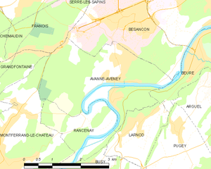
Avanne-Aveney
- commune in Doubs, France
Hiking in Avanne-Aveney
Avanne-Aveney is a picturesque area in the Jura region of France, known for its beautiful landscapes and outdoor activities, including hiking. Here are some highlights and tips for hiking in this area:...
- Country:
- Postal Code: 25720
- Coordinates: 47° 12' 8" N, 5° 57' 51" E
- GPS tracks (wikiloc): [Link]
- AboveSeaLevel: 232 м m
- Area: 8.62 sq km
- Population: 2277
- Web site: [Link]


Larnod
- commune in Doubs, France
Hiking in Larnod
Larnod, located in the Rhône-Alpes region of France, offers picturesque hiking opportunities amid stunning natural landscapes. Here are some key aspects of hiking in the area:...
- Country:
- Postal Code: 25720
- Coordinates: 47° 11' 9" N, 5° 58' 19" E
- GPS tracks (wikiloc): [Link]
- Area: 4.05 sq km
- Population: 772


Pugey
- commune in Doubs, France
Hiking in Pugey
Pugey, located in the Doubs department of France, is a picturesque area that offers a variety of hiking opportunities amidst beautiful natural landscapes. The region is characterized by rolling hills, lush forests, and striking geological formations, making it an ideal destination for both novice and experienced hikers....
- Country:
- Postal Code: 25720
- Coordinates: 47° 11' 5" N, 5° 59' 26" E
- GPS tracks (wikiloc): [Link]
- Area: 7.32 sq km
- Population: 759

Fontain
- commune in Doubs, France
Hiking in Fontain
Fontain, located near the French city of Grenoble in the Auvergne-Rhône-Alpes region, offers a variety of hiking opportunities that cater to different skill levels and interests. The area is characterized by stunning natural landscapes, including mountains, forests, and picturesque views of the surrounding valleys....
- Country:
- Postal Code: 25660
- Coordinates: 47° 11' 55" N, 6° 1' 34" E
- GPS tracks (wikiloc): [Link]
- Area: 16.27 sq km
- Population: 1009
- Web site: [Link]