Bezins-Garraux (Bezins-Garraux)

- commune in Haute-Garonne, France
- Country:

- Postal Code: 31440
- Coordinates: 42° 55' 57" N, 0° 41' 19" E


- GPS tracks (wikiloc): [Link]
- Area: 7.71 sq km
- Population: 41
- Wikipedia en: wiki(en)
- Wikipedia: wiki(fr)
- Wikidata storage: Wikidata: Q1345959
- Wikipedia Commons Category: [Link]
- Freebase ID: [/m/03nq1hj]
- Freebase ID: [/m/03nq1hj]
- GeoNames ID: Alt: [6613484]
- GeoNames ID: Alt: [6613484]
- SIREN number: [213100670]
- SIREN number: [213100670]
- BnF ID: [15255063b]
- BnF ID: [15255063b]
- PACTOLS thesaurus ID: [pcrtFKxunWzJFS]
- PACTOLS thesaurus ID: [pcrtFKxunWzJFS]
- INSEE municipality code: 31067
- INSEE municipality code: 31067
Shares border with regions:


Arguenos
- commune in Haute-Garonne, France
- Country:
- Postal Code: 31160
- Coordinates: 42° 58' 16" N, 0° 43' 26" E
- GPS tracks (wikiloc): [Link]
- Area: 11.09 sq km
- Population: 70

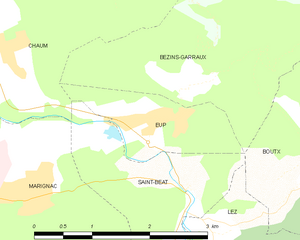
Eup
- commune in Haute-Garonne, France
- Country:
- Postal Code: 31440
- Coordinates: 42° 55' 38" N, 0° 41' 24" E
- GPS tracks (wikiloc): [Link]
- Area: 2.22 sq km
- Population: 127
Moncaup
- commune in Haute-Garonne, France
- Country:
- Postal Code: 31160
- Coordinates: 42° 58' 40" N, 0° 42' 23" E
- GPS tracks (wikiloc): [Link]
- Area: 7.14 sq km
- Population: 37

Boutx
- commune in Haute-Garonne, France
- Country:
- Postal Code: 31440
- Coordinates: 42° 55' 4" N, 0° 42' 56" E
- GPS tracks (wikiloc): [Link]
- Area: 47.28 sq km
- Population: 240
Chaum
- commune in Haute-Garonne, France
- Country:
- Postal Code: 31440
- Coordinates: 42° 56' 3" N, 0° 39' 19" E
- GPS tracks (wikiloc): [Link]
- Area: 5.7 sq km
- Population: 186