Biesheim (Biesheim)

- commune in Haut-Rhin, France
- Country:

- Postal Code: 68600
- Coordinates: 48° 2' 27" N, 7° 32' 36" E


- GPS tracks (wikiloc): [Link]
- Area: 16.55 sq km
- Population: 2546
- Web site: https://www.biesheim.fr/
- Wikipedia en: wiki(en)
- Wikipedia: wiki(fr)
- Wikidata storage: Wikidata: Q326568
- Wikipedia Commons Category: [Link]
- Freebase ID: [/m/03ns325]
- Freebase ID: [/m/03ns325]
- GeoNames ID: Alt: [3032712]
- GeoNames ID: Alt: [3032712]
- SIREN number: [216800367]
- SIREN number: [216800367]
- BnF ID: [152717402]
- BnF ID: [152717402]
- VIAF ID: Alt: [136984193]
- VIAF ID: Alt: [136984193]
- GND ID: Alt: [4782828-6]
- GND ID: Alt: [4782828-6]
- INSEE municipality code: 68036
- INSEE municipality code: 68036
Shares border with regions:
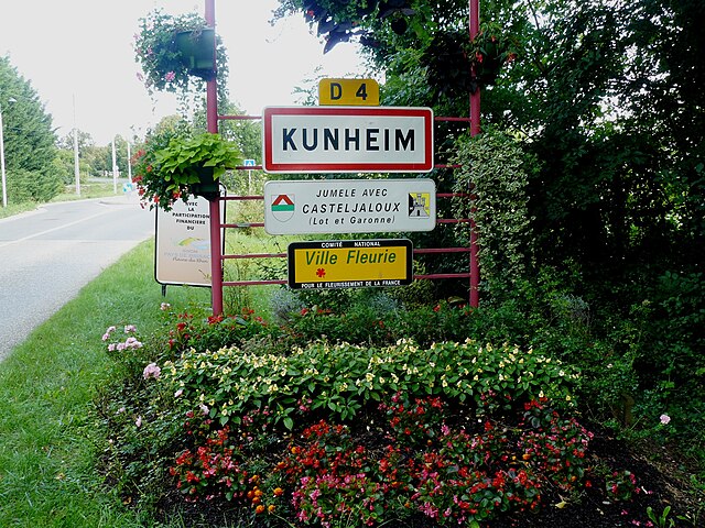
Kunheim
- commune in Haut-Rhin, France
- Country:
- Postal Code: 68320
- Coordinates: 48° 4' 35" N, 7° 32' 4" E
- GPS tracks (wikiloc): [Link]
- Area: 11.75 sq km
- Population: 1758
- Web site: [Link]


Urschenheim
- commune in Haut-Rhin, France
- Country:
- Postal Code: 68320
- Coordinates: 48° 5' 10" N, 7° 29' 10" E
- GPS tracks (wikiloc): [Link]
- Area: 6.42 sq km
- Population: 710
- Web site: [Link]


Volgelsheim
- commune in Haut-Rhin, France
- Country:
- Postal Code: 68600
- Coordinates: 48° 0' 56" N, 7° 32' 52" E
- GPS tracks (wikiloc): [Link]
- AboveSeaLevel: 192 м m
- Area: 8.64 sq km
- Population: 2512
- Web site: [Link]


Vogelgrun
- commune in Haut-Rhin, France
- Country:
- Postal Code: 68600
- Coordinates: 48° 0' 45" N, 7° 34' 16" E
- GPS tracks (wikiloc): [Link]
- Area: 5.03 sq km
- Population: 669

Widensolen
- commune in Haut-Rhin, France
- Country:
- Postal Code: 68320
- Coordinates: 48° 3' 45" N, 7° 28' 48" E
- GPS tracks (wikiloc): [Link]
- Area: 10.67 sq km
- Population: 1190


Wolfgantzen
- commune in Haut-Rhin, France
- Country:
- Postal Code: 68600
- Coordinates: 48° 1' 41" N, 7° 30' 6" E
- GPS tracks (wikiloc): [Link]
- Area: 9.38 sq km
- Population: 1054