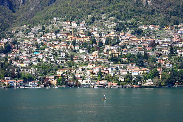
Blevio (Blevio)
.svg)
- Italian comune
 Hiking in Blevio
Blevio is a charming village located on the eastern shore of Lake Como in Italy, offering stunning views and a unique hiking experience. The terrain around Blevio is quite varied, with hills, forests, and beautiful lake vistas, making it an ideal spot for both leisurely walks and more challenging hikes. Here are some key points to consider if you’re planning a hiking trip in Blevio:
Hiking Trails:
-
Sentiero del Viandante: This is a famous trail that runs along the eastern shore of Lake Como. Portions of this trail can be accessed from Blevio, offering scenic views of the lake, the mountains, and surrounding villages.
-
Monte Bregagno: A more challenging hike, Monte Bregagno provides rewarding panoramas of the lake and surrounding mountains. The trail can be steep in parts, so proper footwear and preparation are essential.
-
Trail to Torno: This is a relatively easier hike from Blevio to the nearby village of Torno. The trail is well-marked and offers beautiful views of the lake and the lush landscape.
Best Time to Hike:
- Spring and Autumn: These seasons are particularly pleasant for hiking, with mild temperatures and blooming flora in spring or colorful foliage in autumn.
- Summer: Be prepared for warmer temperatures; morning hikes can be more comfortable.
What to Bring:
- Hiking Boots: Sturdy footwear is crucial due to the varying terrain.
- Water and Snacks: Staying hydrated is important, especially on longer hikes.
- Weather Gear: Check the forecast and bring a light jacket or rain gear if needed.
- Map or GPS: Ensure you have a map or a GPS-enabled device, as some trails may not be well marked.
Local Attractions:
After your hike, explore the beautiful village of Blevio itself, with its quaint streets, historical architecture, and local restaurants. Don't miss the opportunity to enjoy some of the delicious local cuisine or relax by the lakeside.
Safety Tips:
- Always inform someone about your hiking plans.
- Check trail conditions before heading out.
- Stay on designated trails to minimize the impact on the environment.
Blevio offers a unique blend of natural beauty and cultural charm, making it a perfect destination for hikers and nature enthusiasts alike. Enjoy your adventure!
- Country:

- Postal Code: 22020
- Local Dialing Code: 031
- Licence Plate Code: CO
- Coordinates: 45° 50' 0" N, 9° 6' 0" E


- GPS tracks (wikiloc): [Link]
- AboveSeaLevel: 231 м m
- Area: 5.47 sq km
- Population: 1182
- Web site: http://www.comune.blevio.co.it/
- Wikipedia en: wiki(en)
- Wikipedia: wiki(it)
- Wikidata storage: Wikidata: Q244131
- Wikipedia Commons Gallery: [Link]
- Wikipedia Commons Category: [Link]
- Freebase ID: [/m/0gh_bw]
- GeoNames ID: Alt: [6542480]
- VIAF ID: Alt: [243228591]
- OSM relation ID: [46263]
- MusicBrainz area ID: [ec3a2ebc-d518-41db-8e8d-754e705efa34]
- ISTAT ID: 013026
- Italian cadastre code: A905
Shares border with regions:

Como
- Italian city
Hiking in Como
Hiking in Como, Italy, offers stunning views and diverse trails, making it a popular destination for outdoor enthusiasts. The area around Lake Como features a combination of lakeside paths, mountains, and picturesque villages, providing options for hikers of all skill levels. Here are some key points to consider when hiking in the Como region:...
- Country:
- Postal Code: 22100
- Local Dialing Code: 031
- Licence Plate Code: CO
- Coordinates: 45° 48' 37" N, 9° 5' 10" E
- GPS tracks (wikiloc): [Link]
- AboveSeaLevel: 201 м m
- Area: 37.34 sq km
- Population: 84378
- Web site: [Link]


Brunate
- Italian comune
Hiking in Brunate
Brunate, a charming commune in the Lombardy region of Italy, is known not only for its stunning views of Lake Como but also for its excellent hiking opportunities. Here are some highlights for hiking in Brunate:...
- Country:
- Postal Code: 22034
- Local Dialing Code: 031
- Licence Plate Code: CO
- Coordinates: 45° 49' 0" N, 9° 6' 0" E
- GPS tracks (wikiloc): [Link]
- AboveSeaLevel: 715 м m
- Area: 2.03 sq km
- Population: 1715
- Web site: [Link]


Cernobbio
- Italian comune
Hiking in Cernobbio
Cernobbio, located on the western shore of Lake Como in Italy, is a picturesque town surrounded by stunning natural landscapes and offers various hiking opportunities. Here are some highlights for hiking in and around Cernobbio:...
- Country:
- Postal Code: 22012
- Local Dialing Code: 031
- Licence Plate Code: CO
- Coordinates: 45° 50' 17" N, 9° 4' 33" E
- GPS tracks (wikiloc): [Link]
- AboveSeaLevel: 202 м m
- Area: 12.28 sq km
- Population: 6718
- Web site: [Link]


Faggeto Lario
- Italian comune
Hiking in Faggeto Lario
Faggeto Lario, located along the eastern shore of Lake Como in Italy, is a picturesque village surrounded by stunning landscapes, making it a great destination for hiking enthusiasts. The area offers a variety of hiking trails that cater to different skill levels, from easy walks to more challenging hikes....
- Country:
- Postal Code: 22020
- Local Dialing Code: 031
- Licence Plate Code: CO
- Coordinates: 45° 51' 0" N, 9° 10' 0" E
- GPS tracks (wikiloc): [Link]
- AboveSeaLevel: 533 м m
- Area: 17.52 sq km
- Population: 1213
- Web site: [Link]


Torno
- Italian comune
Hiking in Torno
Torno, located along the western shore of Lake Como in Lombardy, Italy, is a charming village that offers several opportunities for hiking and enjoying the stunning natural beauty of the area. Here’s what you need to know about hiking in Torno:...
- Country:
- Postal Code: 22020
- Local Dialing Code: 031
- Licence Plate Code: CO
- Coordinates: 45° 51' 0" N, 9° 7' 0" E
- GPS tracks (wikiloc): [Link]
- AboveSeaLevel: 225 м m
- Area: 7.53 sq km
- Population: 1137
- Web site: [Link]

Moltrasio
- Italian comune
Hiking in Moltrasio
Moltrasio is a charming village located on the western shore of Lake Como in Italy, known for its picturesque views and beautiful landscapes. Hiking in this area offers a wonderful opportunity to explore both the natural beauty and the rich cultural heritage of the region. Here are some highlights and tips for hiking in and around Moltrasio:...
- Country:
- Postal Code: 22010
- Local Dialing Code: 031
- Licence Plate Code: CO
- Coordinates: 45° 51' 38" N, 9° 5' 50" E
- GPS tracks (wikiloc): [Link]
- AboveSeaLevel: 247 м m
- Area: 8.9 sq km
- Population: 1621
- Web site: [Link]