Bolquère (Bolquère)

- commune in Pyrénées-Orientales, France
- Country:

- Postal Code: 66210
- Coordinates: 42° 30' 11" N, 2° 4' 39" E


- GPS tracks (wikiloc): [Link]
- AboveSeaLevel: 1613 м m
- Area: 17.61 sq km
- Population: 799
- Web site: http://www.mairiedebolquere.com
- Wikipedia en: wiki(en)
- Wikipedia: wiki(fr)
- Wikidata storage: Wikidata: Q1101891
- Wikipedia Commons Category: [Link]
- Freebase ID: [/m/03h3s20]
- Freebase ID: [/m/03h3s20]
- GeoNames ID: Alt: [3031859]
- GeoNames ID: Alt: [3031859]
- SIREN number: [216600205]
- SIREN number: [216600205]
- BnF ID: [15270931d]
- BnF ID: [15270931d]
- OSM relation ID: [1966208]
- OSM relation ID: [1966208]
- Gran Enciclopèdia Catalana ID: [0010969]
- Gran Enciclopèdia Catalana ID: [0010969]
- INSEE municipality code: 66020
- INSEE municipality code: 66020
Shares border with regions:


Les Angles
- commune in Pyrénées-Orientales, France
- Country:
- Postal Code: 66210
- Coordinates: 42° 34' 40" N, 2° 4' 28" E
- GPS tracks (wikiloc): [Link]
- Area: 43.2 sq km
- Population: 528
- Web site: [Link]

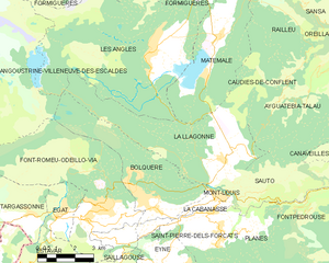
La Llagonne
- commune in Pyrénées-Orientales, France
- Country:
- Postal Code: 66210
- Coordinates: 42° 31' 35" N, 2° 7' 15" E
- GPS tracks (wikiloc): [Link]
- Area: 23.09 sq km
- Population: 226
- Web site: [Link]


La Cabanasse
- commune in Pyrénées-Orientales, France
- Country:
- Postal Code: 66210
- Coordinates: 42° 30' 4" N, 2° 6' 54" E
- GPS tracks (wikiloc): [Link]
- Area: 3.26 sq km
- Population: 662
- Web site: [Link]


Eyne
- commune in Pyrénées-Orientales, France
- Country:
- Postal Code: 66800
- Coordinates: 42° 28' 25" N, 2° 4' 57" E
- GPS tracks (wikiloc): [Link]
- Area: 20.36 sq km
- Population: 126


Font-Romeu-Odeillo-Via
- commune in Pyrénées-Orientales, France
- Country:
- Postal Code: 66120
- Coordinates: 42° 29' 52" N, 2° 2' 2" E
- GPS tracks (wikiloc): [Link]
- Area: 29.6 sq km
- Population: 1954
- Web site: [Link]

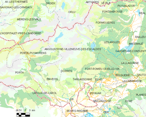
Angoustrine-Villeneuve-des-Escaldes
- commune in Pyrénées-Orientales, France
- Country:
- Postal Code: 66760
- Coordinates: 42° 28' 40" N, 1° 57' 10" E
- GPS tracks (wikiloc): [Link]
- AboveSeaLevel: 1380 м m
- Area: 87.87 sq km
- Population: 709
- Web site: [Link]