Boncourt-sur-Meuse (Boncourt-sur-Meuse)

- commune in Meuse, France
- Country:

- Postal Code: 55200
- Coordinates: 48° 48' 8" N, 5° 34' 18" E


- GPS tracks (wikiloc): [Link]
- Area: 10.84 sq km
- Population: 328
- Wikipedia en: wiki(en)
- Wikipedia: wiki(fr)
- Wikidata storage: Wikidata: Q723955
- Wikipedia Commons Category: [Link]
- Freebase ID: [/m/03qdplz]
- GeoNames ID: Alt: [6449791]
- SIREN number: [215500588]
- BnF ID: [152647261]
- INSEE municipality code: 55058
Shares border with regions:


Vignot
- commune in Meuse, France
- Country:
- Postal Code: 55200
- Coordinates: 48° 46' 26" N, 5° 36' 31" E
- GPS tracks (wikiloc): [Link]
- Area: 16.02 sq km
- Population: 1300
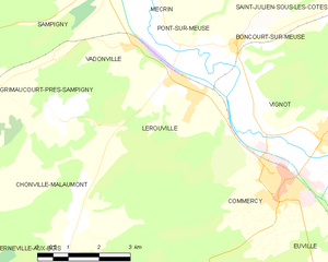
Lérouville
- commune in Meuse, France
- Country:
- Postal Code: 55200
- Coordinates: 48° 47' 30" N, 5° 32' 39" E
- GPS tracks (wikiloc): [Link]
- Area: 14.38 sq km
- Population: 1465

Pont-sur-Meuse
- commune in Meuse, France
- Country:
- Postal Code: 55200
- Coordinates: 48° 48' 6" N, 5° 32' 53" E
- GPS tracks (wikiloc): [Link]
- Area: 3.63 sq km
- Population: 136


Mécrin
- commune in Meuse, France
- Country:
- Postal Code: 55300
- Coordinates: 48° 49' 31" N, 5° 31' 58" E
- GPS tracks (wikiloc): [Link]
- Area: 10.19 sq km
- Population: 225
Apremont-la-Forêt
- commune in Meuse, France
- Country:
- Postal Code: 55300
- Coordinates: 48° 51' 19" N, 5° 38' 21" E
- GPS tracks (wikiloc): [Link]
- Area: 32.89 sq km
- Population: 396
Girauvoisin
- commune in Meuse, France
- Country:
- Postal Code: 55200
- Coordinates: 48° 48' 14" N, 5° 37' 42" E
- GPS tracks (wikiloc): [Link]
- Area: 5.06 sq km
- Population: 69
Saint-Julien-sous-les-Côtes
- commune in Meuse, France
- Country:
- Postal Code: 55200
- Coordinates: 48° 49' 5" N, 5° 36' 48" E
- GPS tracks (wikiloc): [Link]
- Area: 4.95 sq km
- Population: 145